
FL-MHSM: Mastering Multi-Hazard Mapping through Spatially-Adaptive Fusion
FL-MHSM: Spatially-adaptive Fusion and Ensemble Learning for Flood-Landslide Multi-Hazard Susceptibility Mapping at Regional Scale
The paper introduces FL-MHSM, a spatially-adaptive deep learning framework for joint Flood-Landslide Multi-Hazard Susceptibility Mapping. It utilizes a two-level spatial partitioning strategy and a soft-gating Mixture of Experts (MoE) model to integrate probabilistic Early Fusion (EF) and tree-based Late Fusion (LF), achieving SOTA predictive performance in regional studies across Kerala (India) and Nepal.
TL;DR
Predicting where a flood or a landslide might strike is difficult; predicting both simultaneously while accounting for their interactions is a monumental challenge. FL-MHSM (Flood-Landslide Multi-Hazard Susceptibility Mapping) bridges this gap. By employing a Mixture of Experts (MoE) that blends joint probabilistic learning (Early Fusion) with robust independent baselines (Late Fusion), this framework sets a new standard for regional risk assessment, significantly improving recall and reducing predictive uncertainty in complex terrains like the Himalayas and the Western Ghats.
Context: Beyond the Simple Overlay
Historically, Multi-Hazard Susceptibility Mapping (MHSM) has been treated as a "post-processing" task. Scientists would create a flood map and a landslide map independently, then stack them together using weighted averages (Late Fusion).
The Problem? This approach ignores two critical factors:
- Inter-hazard Dependence: Natural hazards are rarely independent. A heavy monsoon can trigger both floods and landslides simultaneously, governed by a shared latent environmental "stress."
- Spatial Heterogeneity: A model trained for the coastal plains of Kerala will fail in the mountainous Western Ghats. Environmental drivers (slope, drainage, LULC) change their behavior across ecological zones.
Methodology: The "Early + Late" Hybrid Architecture
The core innovation of this paper is the Mixture of Experts (MoE). It doesn't choose between modeling hazards jointly or separately; it learns to do both and weights them based on the local context.
1. The Experts
- Early Fusion (EF): Uses a Multilayer Perceptron (MLP) with a Multivariate Gaussian (MVG) output. Instead of predicting a simple 0 or 1, it predicts a mean vector and a covariance matrix. This allows the model to capture the correlation between hazards and the aleatoric uncertainty of the prediction.
- Late Fusion (LF): An XGBoost-based baseline that treats each hazard as a distinct classification task, preserving the sharpest hazard-specific features.
2. The Gating Mechanism
The MoE Gating Network acts as a referee. It looks at the outputs of both the EF and LF models and assigns weights (, ). If a region has high inter-hazard correlation, it leans toward the EF; if the hazards are spatially decoupled, it leans toward LF.
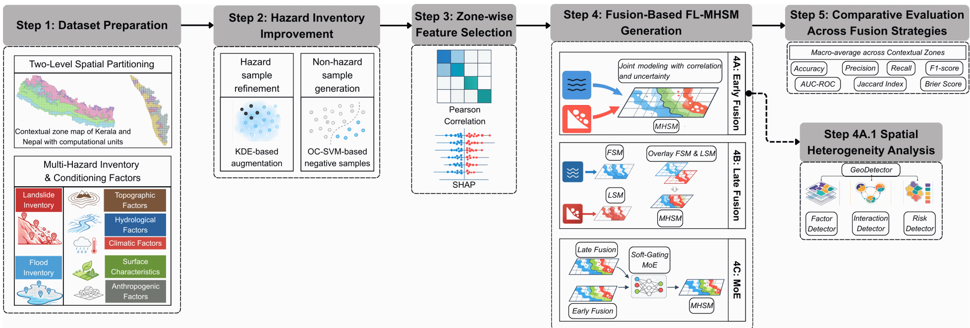 Figure 1: The FL-MHSM workflow—integrating spatial partitioning, dual-expert modeling, and soft-gating ensemble.
Spatial Intelligence: Two-Level Partitioning
To solve the "one-size-fits-all" model problem, the authors introduced:
- Computational Units: 15km x 15km overlapping grids for data-parallel processing.
- Contextual Zones: Segmenting the map into ecoregions (e.g., Ecologically Sensitive Zones in Kerala). Feature selection (via SHAP) is performed independently within each zone, ensuring the model focuses on the most relevant local drivers.
Results and Performance
The MoE model demonstrated a "best of both worlds" effect. It maintained the high discriminative power (AUC-ROC) of independent models while adopting the smoother, more realistic compound distributions of the joint models.
| Metric (Nepal) | Late Fusion (XGB) | Early Fusion (MVG) | MoE (Proposed) |
|---|---|---|---|
| Flood AUC-ROC | 0.918 | 0.900 | 0.913 |
| Landslide AUC-ROC | 0.877 | 0.878 | 0.914 |
| Landslide Recall | 0.810 | 0.831 | 0.901 |
One of the most profound insights was the detection of negative inter-hazard correlation in almost all zones. This suggests that while both hazards are triggered by rainfall, they rarely reach peak susceptibility in the exact same pixels—landslides favor steep slopes, while floods dominate the gentler receiving basins.
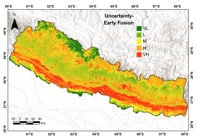 Figure 2: Multi-hazard Susceptibility Maps of Kerala. The bivariate colormap represents the combined severity of floods and landslides.
Critical Insight: Why it Works
The Geodetector analysis conducted on the MoE outputs revealed that the model successfully "learned" the landscape physics. In the Himalayas (Nepal), proximity to glacier lakes was the dominant factor for landslides, while terrain slope dominated in Kerala's ESZ1. By allowing the MoE to weigh joint vs. separate modeling, the framework avoids the "over-smoothing" of independent features while capturing the "co-occurrence" logic.
Conclusion & Future Work
FL-MHSM proves that deep learning for natural hazards must be spatially adaptive. The MoE approach offers a robust path forward for regional disaster management by integrating local ecological context with joint probabilistic inference.
Limitations: The model is currently "static"—it uses fixed conditioning factors. The next frontier in this research will involve dynamic/temporal cascades, where the model accounts for how a landslide (as a primary event) might block a river and cause a subsequent flood (as a secondary event).