
VLMs vs. The World: Decoding Geographic Intelligence in Foundation Models
Where Do Vision-Language Models Fail? World Scale Analysis for Image Geolocalization
The paper introduces a world-scale benchmark evaluating nine state-of-the-art Vision-Language Models (VLMs) for zero-shot country-level image geolocalization using ground-view imagery. The study identifies the Qwen3-VL-4B model as a top performer, outperforming task-specific models on datasets like CityGuessr with specialized evaluation metrics.
TL;DR
Can an AI look at a random street and tell you which country it's in without a GPS? This paper benchmarks nine Vision-Language Models (VLMs) on world-scale geolocalization. The results show that while models like Qwen3-VL can rival human players in zero-shot country identification, they suffer from a massive "Urban Bias" and a strange "Inverted Scaling" where bigger models aren't always better at reading the map.
Problem: The Limits of Pixel Matching
Traditional geolocalization is essentially a massive game of "spot the difference." Systems like NetVLAD retrieve the closest match from millions of geo-tagged images. However, this is computationally "heavy" and fails when the exact street isn't in the database.
The authors argue that we should treat geolocalization as a semantic reasoning task. A model should know that certain road markings, tree species (Biomes), and architectural styles belong to specific regions. The real question is: Do current VLMs actually "know" the world, or are they just making lucky guesses?
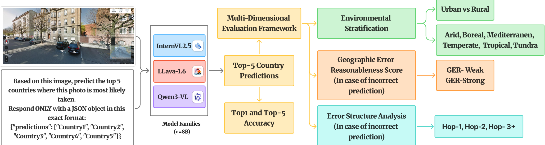
Methodology: The GER Score
The core contribution of this work is the Geographic Error Reasonableness (GER) score.
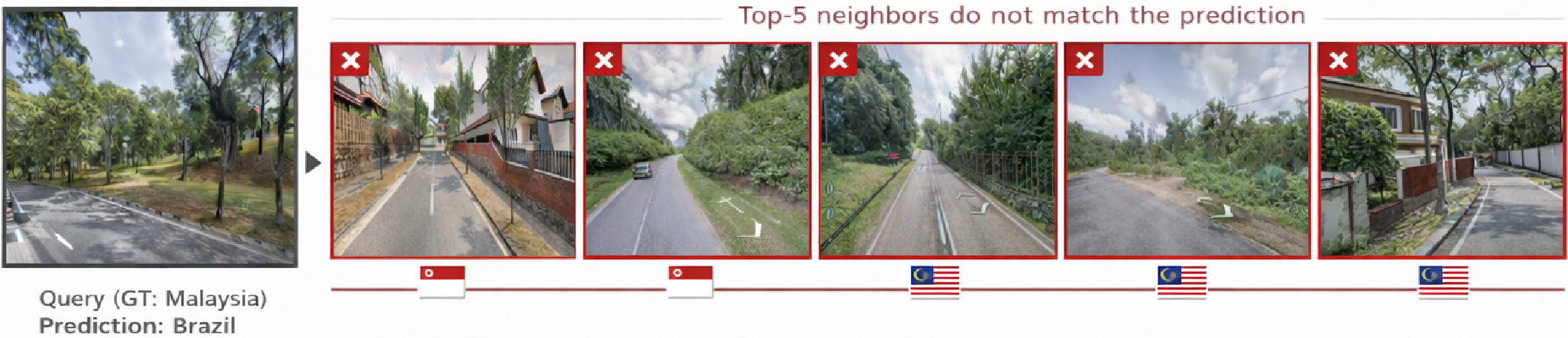
- The Problem with Accuracy: If a model guesses "Canada" for an image taken in "USA," it's wrong. But if it guesses "Brazil" for an image in "USA," it's disastrously wrong.
- The Logic of GER: By using CLIP/SigLIP embeddings, the authors find the 5 most visually similar images (neighbors). If the model's incorrect guess matches the country of one of those visual neighbors, it’s "Wrong for the Right Reasons" (High GER). If not, the model is simply hallucinating.
Key Results & Anomalies
1. The Qwen Dominance & Inverted Scaling
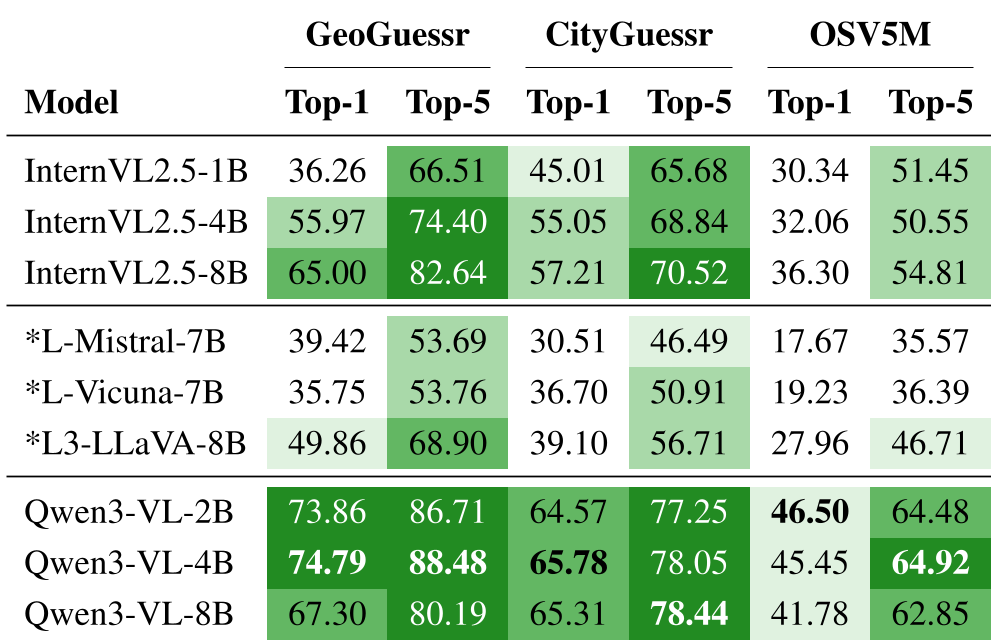
Qwen3-VL-4B emerged as a surprisingly powerful geolocator, hitting 74.79% Top-1 accuracy on the GeoGuessr-50k dataset. Intriguingly, the 8B variant performed worse than the 4B and 2B models. This suggests that as language models get larger, they might prioritize general language fluency over the specific spatial cues needed for geolocation.
2. The Urban-Rural Divide
The study confirmed a brutal reality: models are "city slickers." All models performed significantly better in urban environments (signage, landmarks) than rural ones.
- CityGuessr Gap: Qwen3-VL-4B achieved ~68% accuracy in cities but dropped to ~41% in rural areas.
- Why? Rural imagery is visually heterogeneous, making "the visual manifold" much harder to map without specific training data.
3. Biome Sensitivity
Geography matters. Models perform excellently in Boreal and Temperate regions (often well-represented in training data like North America and Europe) but struggle significantly in Tropical zones. In OSV5M, Tropical regions were the hardest to identify, likely due to visual similarity across dozens of diverse countries.
Critical Insight: Failure Analysis
The "Neighbor Hop Distance" analysis revealed that when top-tier models like Qwen3-VL fail, they usually guess a neighboring country (Hop-1). Only 10.2% of LLaVA-Vicuna's errors were neighbors, while nearly 90% were "distant" (random) errors. This proves that high-performing VLMs actually possess a structured internal "map" of the world.
Conclusion & Future Work
The paper concludes that while VLMs are "promising" for zero-shot tasks, they aren't ready to replace retrieval-based systems for high-precision GPS tasks. The future likely lies in hybrid systems: using the VLM for global "semantic narrowing" (e.g., "This is Mediterranean Europe") and then using retrieval for the final city-block precision.
Takeaway for Practitioners: If you are building an AI for geographic tasks, don't assume a bigger model is better. Focus on Environmental Stratification and fine-tuning (which the authors showed can boost accuracy by +39%) to bridge the urban-rural gap.