
Address-Based Crowdsourcing: The End of GPS Dependency for Indoor Positioning?
Address-based crowdsourcing radio map construction for Wi-Fi positioning systems
The paper proposes an address-based crowdsourcing method for constructing Wi-Fi radio maps without GPS or manual fingerprinting. By leveraging users' home/office addresses and clustering Wi-Fi signal patterns, it achieves high-precision indoor positioning, reaching sub-10m accuracy and significant floor-level detection capabilities.
TL;DR
Researchers from KAIST have developed a method to build ultra-precise indoor Wi-Fi radio maps without ever needing a GPS signal. By identifying the "home" and "office" fingerprints of mobile users and tagging them with existing address databases, they’ve achieved sub-10-meter accuracy and reliable floor-level detection—overcoming the biggest hurdles in indoor navigation.
The Problem: The "Indoor Blind Spot" of GPS
We spend 90% of our time indoors, yet our primary positioning technology, GPS, fails the moment we step under a roof. Current Wi-Fi Positioning Systems (WPS) try to fix this by "war-driving" (scanning Wi-Fi from a car) or using smartphones to tag Wi-Fi data with GPS coordinates.
The flaw? If the GPS signal is weak indoors, the resulting Wi-Fi map is inaccurate. This "blind leading the blind" approach results in poor horizontal accuracy and a total inability to distinguish between the 1st and 10th floor.
The Insight: Your Address is Your Best Anchor
The authors observed a simple human habit: our phones stay in fixed locations for long periods—usually at home during the night and at work during the day.
Instead of relying on a flickering GPS satellite 20,000 km away, why not use the physical address of the building? By clustering Wi-Fi signals that appear consistently during "home hours," and associating them with a user's known address, the system can "pin" a fingerprint to a precise 3D coordinate.
Methodology: From Clusters to Coordinates
The system follows a logical pipeline to transform raw signals into a usable map:
- Fingerprint Clustering: Analyzing 24-hour signal patterns to separate "Home" clusters from "Work" clusters.
- Address Tagging: Leveraging Geocoding APIs to convert street addresses into latitude, longitude, and floor levels.
- Radio Map Construction: Using the Log-Distance Path Loss (LDPL) model to estimate the location of Access Points (APs) based on the tagged fingerprints.
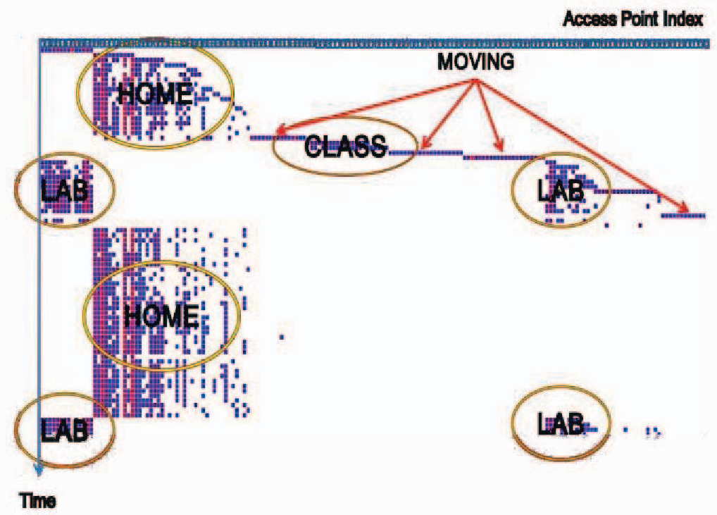 Figure 1: Typical pattern of fingerprints collected over 24 hours, showing clear temporal clusters for home and office environments.
For cases where addresses are unknown, the authors propose using barometric pressure sensors (found in most modern smartphones) to calculate relative altitude, combined with a Force-Directed Graph algorithm to mathematically "nudge" unknown fingerprints into their most likely positions based on signal similarity.
Experimental Results: Beating the Giants
The team tested their method in four diverse areas of Korea, including high-rise apartments (Hanbit Apt) and dense downtown streets (Galleria).
- Horizontal Accuracy: Once the system collected data from 50% of households in an area, the error dropped to under 10 meters. In contrast, commercial solutions like Google WPS hovered around 30-40 meters.
- The Floor Challenge: Unlike GPS-based systems, this method excelled at vertical positioning. With a 90% collection rate, the system correctly identified the exact floor or its immediate neighbors over 90% of the time.
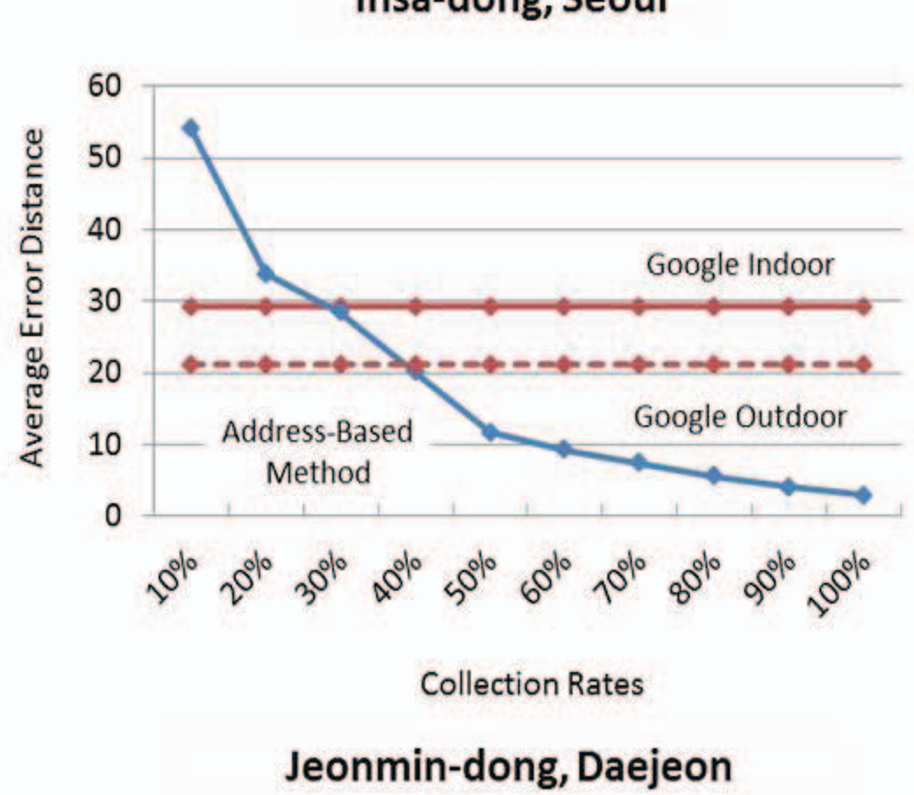 Figure 2: Average error distances across different urban environments compared to Google WPS.
Critical Insight & Future Outlook
The beauty of this research lies in its scalability. It doesn't require specialized hardware or active user participation (which usually fails due to user "indifference").
Limitations: The primary challenge is Privacy. The authors suggest a "Separated Server" architecture—where one server handles addresses and another handles Wi-Fi data—to prevent a single entity from tracking a user's exact movements. However, in an era of strict data regulations (GDPR, CCPA), the ethical collection of residential addresses remains a high hurdle for commercial implementation.
Conclusion: This work proves that we don't need better satellites to find our way indoors; we just need to use the semantic data we already have more intelligently. As smart cities integrate address databases with IoT infrastructure, this method could become the backbone of next-gen indoor emergency services and logistics.