
Beyond Latitude and Longitude: How Crowdsensing and Social Knowledge Fix the "Place Naming" Problem
Autonomous place naming system using opportunistic crowdsensing and knowledge from crowdsourcing
The paper introduces an autonomous place naming system that combines opportunistic crowdsensing from smartphones with knowledge from social network services (SNS). It categorizes places into functional, business, and personal names, achieving SOTA performance by bridging the gap between raw GPS coordinates and human-centric semantic meanings.
TL;DR
Researchers have developed an autonomous system that identifies exactly where you are—not just as a GPS coordinate, but as "Starbucks" or "My Office"—by blending smartphone sensor data (sensing) with social media metadata (crowdsourcing). By analyzing stay patterns and taking "opportunistic" photos, the system slashes the need for users to manually check-in or correct their location.
The Problem: The "100-Meter" Noise Floor
We’ve all experienced it: you try to check-in on a social app, and it gives you a list of 50 nearby places, none of which are actually where you are. Current Location-Based Services (LBS) are fundamentally broken because:
- Inaccuracy: GPS is rarely accurate enough for dense urban environments.
- Density: In cities like Seoul, there can be over 80 businesses within a 100-meter radius.
- Social Gap: Around 22% of visited places aren't even registered on social networks (SNS), or have mismatched granularity.
Methodology: Giving Sensors a "Human Perspective"
The core insight of this paper is that how we act and what we see defines a place better than a coordinate.
1. Behavioral Fingerprints
The system tracks Residence Time (when you visit) and Stay Duration (how long you stay).
- Intuition: If you stay somewhere for 8 hours on a weekday starting at 9 AM, it’s likely a "Professional Office." If you visit at midnight and stay for 30 minutes, it's "Nightlife" or "Travel."
2. Environmental "Eyes"
When a user takes a photo, the system extracts three levels of data:
- OCR Words: Signs that say "Coffee," "Menu," or brand names.
- SIFT (Local): Logos and specific object patterns.
- GIST (Global): The "vibe" of the scene—horizontal lines of supermarket shelves vs. the specific clutter of a cafe.
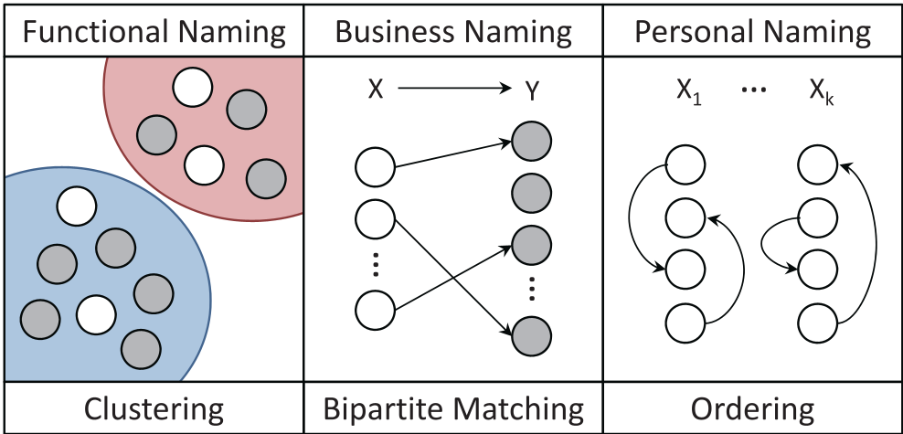
The "Bipartite Balancing" Act
To turn these features into a name, the system treats it as a Bipartite Matching Problem. It creates a graph where crowdsensed data nodes must "flow" to the most likely SNS nodes. It doesn't just look for the closest match; it optimizes the global cost, ensuring that the behavioral "fingerprint" of the user matches the check-in "fingerprint" of the business.
Results: A Massive Leap in Accuracy
The study, conducted in Seoul, demonstrated significant improvements over traditional "Popularity-aided" methods (which just guess the most famous place nearby).
- Functional Naming: The system achieved 56% accuracy in identifying the type of place (e.g., "Food Place"), compared to just 33% for standard methods.
- Business Naming: 84% of the time, the correct business was in the top 10, whereas older methods would have required users to scroll through dozens of entries.
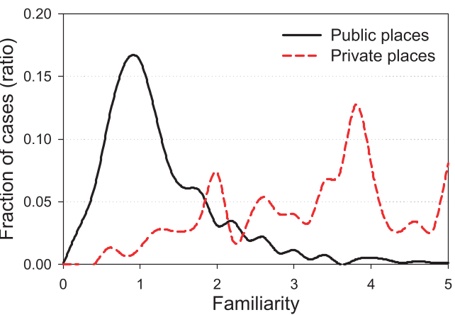
One of the most striking findings is shown in the confusion matrix: traditional lookups often default to "Food Places" because they have the most SNS data. This system uses Stay Duration (as seen in Figure 6) to successfully differentiate a quick meal from a long office shift.
Critical Insight: The Privacy-Utility Tradeoff
While the system is highly effective, the authors acknowledge a major hurdle: Privacy. Uploading images to a server for OCR and GIST analysis is a hard sell for modern users.
Future Outlook: The next logical step for this technology is On-Device Semantic Extraction. By using lightweight local models to extract only the "words" or "features" and discarding the raw photo before it leaves the phone, we could get the benefits of autonomous naming without the surveillance-state drawbacks.
Conclusion
This work transforms the smartphone from a passive GPS tracker into an active observer of human context. By bridging the gap between what sensors see and what humans name, it moves us closer to a future where our devices truly understand where we are—not just where we are "located."