
B-Planner: Leveraging Taxi GPS Big Data to Revolutionize Night Bus Routing
B-Planner: Planning Bidirectional Night Bus Routes Using Large-Scale Taxi GPS Traces
This paper presents B-Planner, a two-phase data-driven framework for planning bidirectional night bus routes using large-scale taxi GPS traces. It introduces a spatio-temporal clustering approach for stop identification and a Bidirectional Probability-based Spreading (BPS) algorithm to optimize route selection under travel time and passenger capacity constraints.
Executive Summary
TL;DR: B-Planner is a sophisticated framework that mines vast taxi GPS data to automatically design night bus routes. By identifying "hot spots" of late-night mobility and solving a complex bidirectional optimization problem, it crafts routes that maximize passenger coverage while respecting strict travel time limits.
Background: Positioned in the intersection of Social Dynamics and Operational Dynamics, this work moves beyond simple "hot-spot" detection to solve a structural urban planning problem. It transitions bus routing from a manual, survey-heavy process to an automated, data-driven one.
The "Asymmetry" Challenge
Prior work in urban computing often focused on optimizing a path from Point A to Point B. However, the authors identify a critical real-world constraint: Bidirectional Asymmetry. In a city, the demand from a residential area to a nightlife hub at 10 PM is not mirrored by the same demand in the opposite direction at the same time. Traditional "shortest path" or single-direction optimizations result in bus routes that may be highly efficient for one leg but near-empty for the return.
Methodology: From GPS Traces to Bus Stops
The authors propose a two-phase technical pipeline:
Phase 1: Intelligent Stop Identification
Unlike standard K-Means which can place stops in unreachable locations (like rivers or buildings), the authors use a grid-based clustering and splitting method. They ensure stops are:
- Reachable: Located at high-connectivity grid cells.
- Walkable: Clusters are split based on a maximum walking distance threshold ().
- Hot: Weighted by Passenger Delivery Records (PDRs).
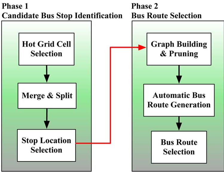 Figure 1: Understanding taxi flows to define potential bus stop connectivity.
Phase 2: Bidirectional Probability-based Spreading (BPS)
The core of the methodology is the BPS algorithm. The routing problem is modeled as finding the Skyline Route—a route that is not "dominated" by any other route in both travel time and passenger volume.
The BPS algorithm uses a heuristic spreading approach:
- It iteratively builds a route graph and prunes edges that violate spatial logic (e.g., zigzagging or moving away from the destination).
- It selects the next stop based on the accumulated passenger flow from all previous stops, ensuring the route captures the "global" maximum rather than just local peaks.
Experimental Results & Real-World Impact
The system was tested on massive Hangzhou taxi data (1.57M trips).
Key Findings:
- Algorithm Convergence: The BPS algorithm consistently converges to an optimal skyline route faster than exponential Top-K search.
- Superiority over Manual Design: The authors compared their "R1" route to a real Hangzhou night bus "R3" implemented by experts. Their data-driven route provided significantly better coverage of night-life centers with higher passenger density.
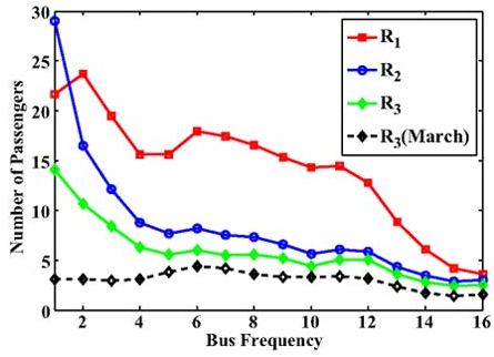 Figure 2: Analysis of the "Accumulation Effect" where B-Planner's suggested stops capture significantly more demand than traditional routes.
Critical Insight & Conclusion
The primary value of B-Planner is its recognition of the Passenger Flow Accumulation Effect. Bus routing is not just about connecting two points; it's about the probability of a passenger at Stop wanting to reach Stop . By utilizing a probability-based spreading mechanism, the authors capture these latent multi-stop dependencies that traditional shortest-path algorithms miss.
Limitations: The current model assumes buses follow the same high-density paths as taxis, which may not always be feasible due to road width or turn restrictions for larger vehicles. Future iterations would benefit from integrating road-network-level constraints directly into the graph-building phase.
Takeaway: As cities move toward "Smart City" paradigms, B-Planner provides a blueprint for how ubiquitous sensors (taxis) can provide the high-resolution data needed to build greener, more efficient public transit systems.