
Reconstructing the Pulse of a City: High-Fidelity Traffic Dynamics from Sparse GPS Traces
Citywide Estimation of Traffic Dynamics via Sparse GPS Traces
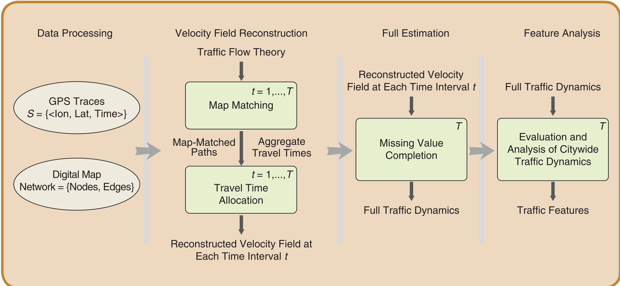
The paper introduces a comprehensive framework for citywide traffic dynamics estimation using sparse GPS traces. It features two primary components: a Wardrop’s Principles-based approach for joint map-matching and travel-time allocation, and a Compressed Sensing (CS) method to reconstruct missing network values.
TL;DR
Estimating citywide traffic dynamics has long been a trade-off between expensive hardware (loop detectors) and noisy, sparse data (GPS traces). This paper bridges the gap by introducing a framework that leverages Wardrop’s Principles for better map-matching and Compressed Sensing to fill temporal gaps. The result? A 52.5% reduction in error and a massive 94% reduction in the data needed for full network recovery.
The "Shortest Distance" Trap
Most existing map-matching algorithms operate on a simple assumption: vehicles take the shortest spatial path between two GPS points. While this holds in free-flowing traffic, it fails miserably in congested cities. In a gridlock, the "shortest path" is often the most congested, leading drivers to take longer detours that are temporally shorter.
The authors argue that by ignoring the temporal information (timestamps) in GPS data and relying solely on spatial coordinates, prior works introduce a systematic bias that propagates into travel time estimation.
Methodology: Physics Meets Signal Processing
1. Velocity Field Reconstruction
Instead of assuming the shortest distance, the authors utilize Wardrop’s Principles of User Equilibrium, which suggests that users choose routes to minimize travel time.
- The Relaxation Algorithm: Starting with a road network at free-flow speeds, the algorithm "relaxes" (lowers) the speeds of road segments if a path's estimated travel time is faster than what the GPS trace reports.
- Collective Intelligence: It uses multiple traces overlapping on the same segments to iteratively converge on a realistic velocity field for the entire city.
2. Filling the Gaps with Compressed Sensing
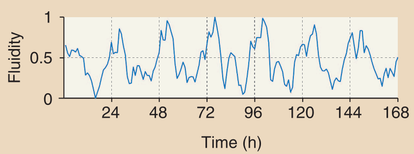
Traffic patterns are not random; they are highly periodic (daily and weekly cycles). By transforming traffic signals into the frequency domain using Discrete Cosine Transform (DCT), the authors found that 95% of the signal energy is contained in just a few frequencies.
By treating traffic estimation as a Compressed Sensing problem, they proved that a full week's worth of traffic (168 hours) can be reconstructed with high accuracy using only 90 random measurements, a 94.64% reduction in data dependency.
Experimental Results
The framework was tested against the state-of-the-art method by Lou et al. using both a synthetic grid and real-world data from San Francisco (Cabspotting dataset).
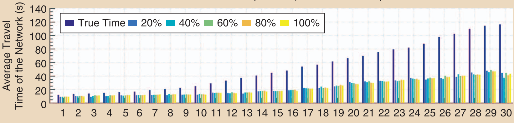
- Accuracy Boost: The method achieved up to 52.5% improvement in Mean Squared Error (MSE) compared to distance-based methods.
- Robustness: Even with only 20% vehicle penetration, the system provides a close approximation of the ground truth, whereas traditional methods fail significantly under congestion.
Critical Insight & Conclusion
The brilliance of this paper lies in its holistic view. It doesn't treat map-matching and travel-time estimation as separate modules but as a joint optimization problem governed by traffic physics. By moving from a "spatial-only" to a "spatio-temporal" paradigm, the authors unlocked the ability to use low-quality, sparse data to produce high-quality urban insights.
Takeaway: Future urban management systems don't necessarily need more sensors; they need smarter algorithms that understand the physical and mathematical structures (sparsity and equilibrium) inherent in human mobility.
Limitations
- Computational Cost: While accurate, the relaxation process can be expensive for massive networks.
- Static Assumption: It assumes traffic is quasi-static within discretized windows, which might miss sudden events like accidents.