
Beyond Keywords: A Collaborative Social-Spatial Learning Approach to GIR
A collaborative learning approach for geographic information retrieval based on social networks
The paper introduces a multi-domain Geographic Information Retrieval (GIR) approach that integrates spatial, temporal, and social data from heterogeneous sources like social networks, web pages, and geodatabases. By utilizing a "Ge-Ontology" and a query contextualization mechanism, the system achieves a collaborative learning environment that adapts to different user expertise levels.
TL;DR
Geographic Information Retrieval (GIR) is evolving from simple map searches to complex, multi-dimensional queries. This paper presents a framework that uses Ge-Ontology to contextualize user queries across three domains: Temporal, Geographical, and Social. By leveraging social network data (like Facebook check-ins) alongside traditional geodatabases (INEGI), the system provides a richer, more "human" response to imprecise queries.
The Granularity Gap: Why Your Search Fails
Most search engines treat "Paris" as a coordinate or a string. However, a neophyte user looking for "tourist spots" has different needs than a GIS expert seeking vector files. The problem is Semantic Granularity:
- Heterogeneity: Data is scattered across gazetteers (structured), web pages (semi-structured), and social media (unstructured).
- Vagueness: Queries like "downtown" or "at morning" are spatially and temporally fuzzy.
- Context Blindness: Current SOTA methods often ignore the social layer—what people do in a place is as important as where the place is.
Methodology: The Ge-Ontology & OntoExplore
The authors solve this by introducing a collaborative learning expert system. The heart of the architecture is the Ge-Ontology, which models entities as either continuants (objects like buildings) or occurrents (events like a protest).
The Query Contextualization Pipeline
- Parsing: Identifying "What, Where, When, Relation, and Event."
- OntoExplore: The algorithm searches the ontology for a concept match. Once found, it extracts a "Contextual Vector" ().
- Cross-Domain Mapping: If the vector identifies a social relation, it triggers a Facebook API call; if it finds a topological relation, it queries a PostGIS database.
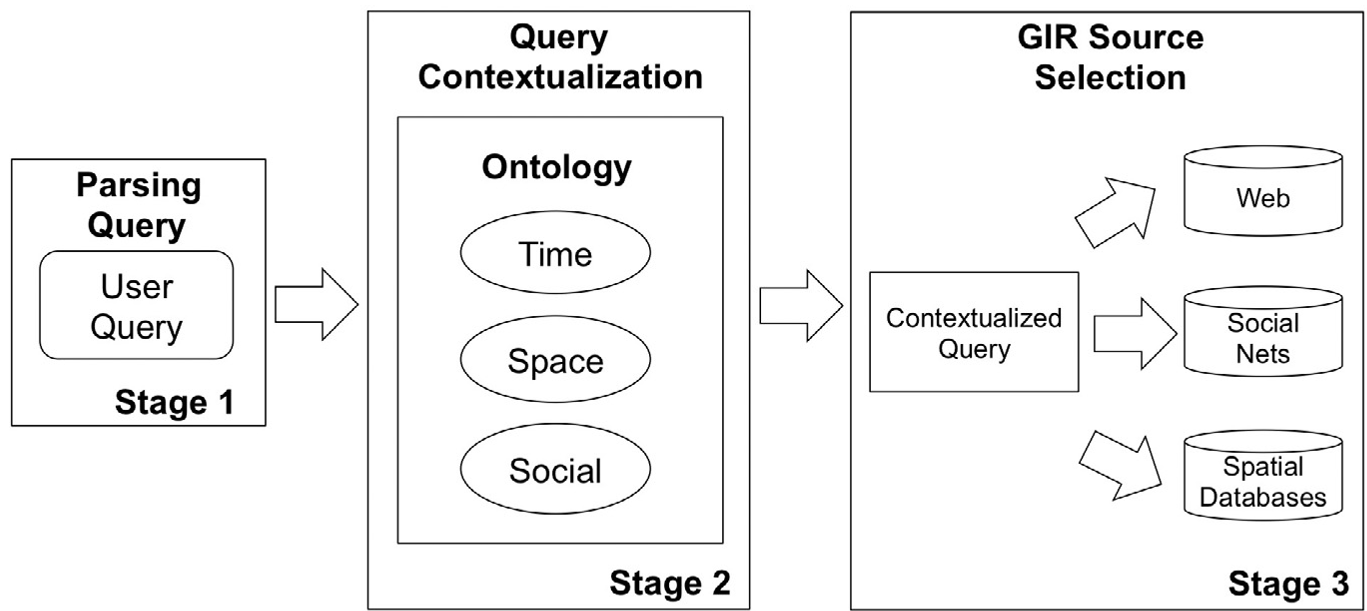 Fig 1: The General Framework of the GIR Methodology showing the integration of heterogeneous data.
The Contextual Vector ()
Instead of simple keyword expansion, the acts as a bridge. For a query about "Touristic places in Mexico City," the vector includes:
- Spatial Cluster: [Bellas Artes Palace, Zocalo, Cathedral]
- Social Cluster: [Check-ins, Labeled photos]
- Temporal Cluster: [Opening hours, Event dates]
Experimental Proof: SOTA Comparison
The authors tested their system against standard keyword-based retrieval (Google) across seven complex query types.
 Table 1: Statistical comparison between GIR and Google baseline. Note the higher number of relevant documents retrieved (Recall) by the proposed method.
Key Findings:
- Precision (0.81): For spatial-heavy queries, the ontology-driven approach significantly limits irrelevant noise.
- Recall (0.70): The system successfully identifies historical events (e.g., "Mexican Revolution") by linking temporal periods (1910–1917) to specific geographic polygons.
Visualization: From Lists to Timelines
One of the most impressive outputs of this research is the transition from a list of results to interactive Spatio-Temporal Timelines. For event-based queries like "Protest Marches," the system visualizes the movement of the event over time on a map, pulling check-in logic from social streams to depict the flow of the crowd.
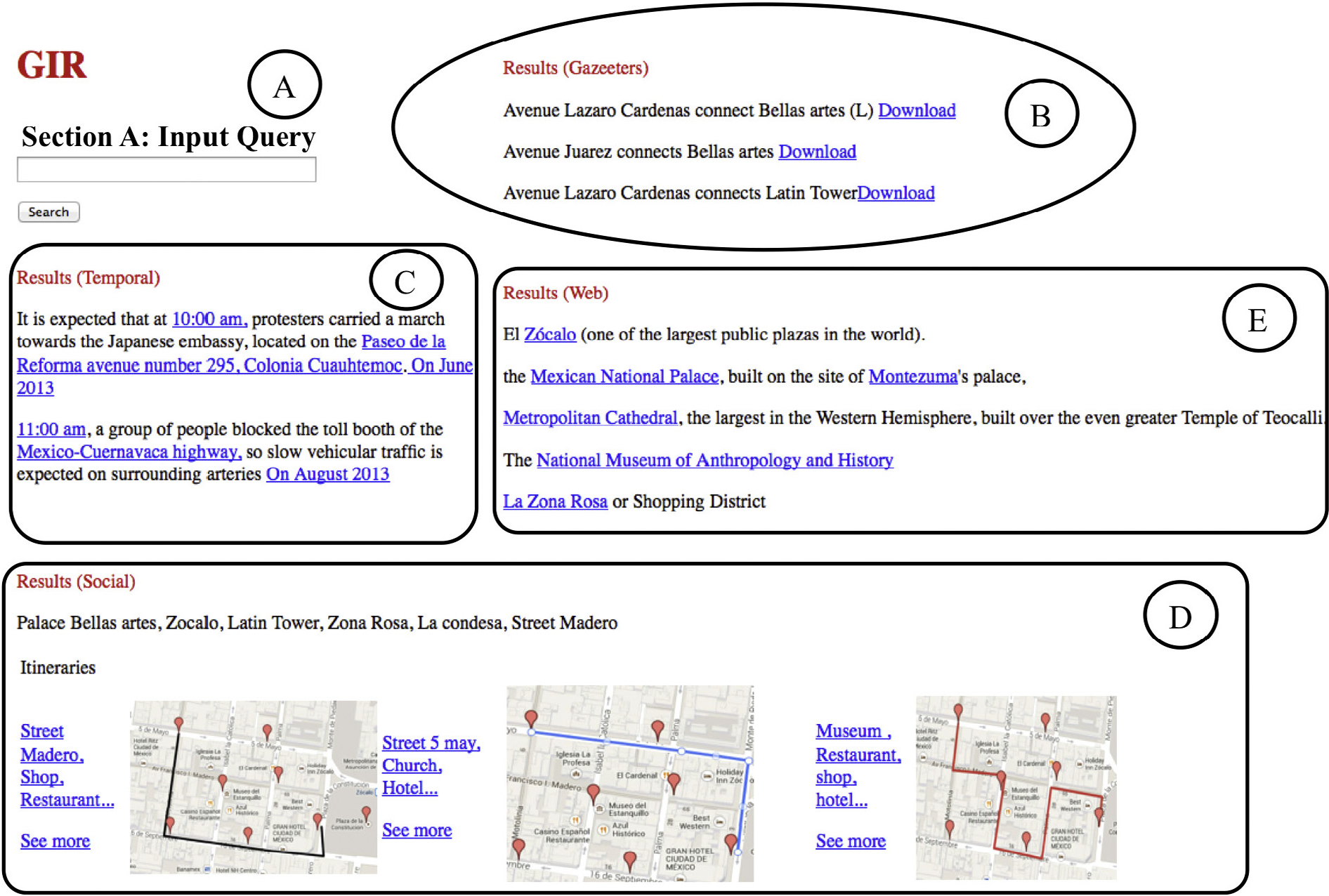 Fig 2: Integrated results showing the intersection of Wikipedia descriptions, Social Network routes, and Geodatabase coordinates.
Critical Insight & Conclusion
While the paper shows robust results, its primary limitation is its dependence on a pre-defined ontology. If a concept isn't in the Ge-Ontology, the system reverts to a higher-level hierarchy, potentially losing precision.
However, the work provides a vital blueprint for GIScience Collaborative Learning. By treating the retrieval process as a learning interaction between different classes of users (Expert vs. Neophyte), it transforms GIR from a data-matching task into a "reasoning" task that effectively mimics human intuition.
Takeaway: In the era of Big Data, the most valuable geographic information isn't just the coordinates—it's the social and temporal context that gives those coordinates meaning.