
Beyond Proximity: Leveraging Flow Networks for Precision Mobile Crowdsourcing
The use of colocation and flow networks in mobile crowdsourcing
This paper introduces a novel geo-casting approach for mobile crowdsourcing that utilizes Colocation and Flow Networks to match in situ tasks with workers. By identifying "communities of spaces" through complex network analysis of human mobility data, the method optimizes worker recruitment based on movement regularities rather than simple distance.
TL;DR
In situ crowdsourcing—tasks that must be performed at specific locations—often fails because it relies on the crude metric of Euclidean distance. This paper proposes a paradigm shift: instead of asking "who is close?", we should ask "who is part of this movement network?" By modeling cities as Colocation and Flow Networks, the authors demonstrate a significant improvement in reaching the right participants at the right time.
Background: The Limits of the "Circle on a Map"
In typical mobile crowdsourcing, if a task is at a flea market, the system pings everyone within a 500-meter radius. This approach is fundamentally flawed because it ignores the vector of human movement. A worker 1km away on a fast-moving train heading toward the market is a better candidate than a worker 100m away who is currently boarding a bus in the opposite direction.
The authors argue that the physical and social structures of a city create "spatiotemporal regularities"—predictable patterns of how people flow between nodes. If we can tap into these flows, we can "geo-cast" tasks with surgical precision.
Methodology: Mapping the Pulse of the City
The researchers propose two distinct mathematical frameworks to represent urban mobility:
- Colocation Networks: These are weighted undirected graphs where nodes represent space-time cubes. An edge exists between two spaces if the same person visited both within a specific timeframe. It captures "shared presence."
- Flow Networks: These are weighted directed graphs representing the actual transition of people from one space to another. This captures the "directional momentum" of the crowd.
From Networks to Communities
Once the networks are built, the authors use the Infomap algorithm—a community detection method based on the logic of random walks. This identifies "Communities of Spaces"—clusters of locations that are intrinsically linked by the movement of people.
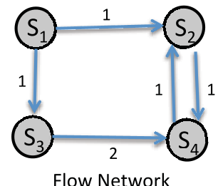 Figure 2: Conceptualization of Colocation and Flow Networks based on inter-space transitions.
Experimental Evidence: The Tokyo Case Study
The authors tested their hypothesis using a massive dataset from the 5th Tokyo Person Trip Survey, encompassing 60 million movement samples across Greater Tokyo.
Visualization of Spatial Communities
The resulting communities (pictured below) show how the city is chopped into functional zones. Interestingly, as the grid resolution increases, the Flow Networks provide a much more nuanced map of how tasks should be distributed compared to simple geometric circles.
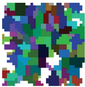 Figure 4: Comparison of communities detected in Colocation vs. Flow Networks at different grid resolutions.
Key Performance Findings
- Recall Dominance: The network-based approaches (especially Flow Networks) showed a much higher Recall than Euclidean proximity. This means the system successfully identifies a larger pool of potential workers who will actually arrive at the task location.
- Precision and Scale: While proximity is "satisfactory" at very small scales, network-based methods become vastly superior as the grid size increases, offering a better F-measure (the balance between precision and recall).
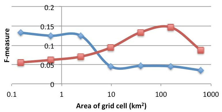 Figure 6(c): F-measure comparison showing Flow Networks outperforming traditional methods.
Critical Insights & Future Outlook
The core takeaway of this work is that geography is not just distance; it is connectivity. In a mobile society, a person’s "location" is better defined by where they are likely to be in 30 minutes than where they are standing now.
Limitations and Challenges:
- Macroscopic Nature: The data used focused on vehicles and trains. To make this work for "last-mile" crowdsourcing, microscopic data (GPS trajectories of pedestrians and bikers) is needed.
- Computational Latency: Generating these networks in real-time for a global population remains a massive engineering challenge.
Future Path: The authors suggest that the next frontier is Transportation Mode-Aware Networks. Integrating whether a user is on a subway or a motorcycle would allow the system to tailor task requests even further—for example, giving a photography task only to those on foot or on bicycles who can easily stop.
This research marks a significant step toward "intelligent" situated systems that understand the rhythm of the city.