
Co-spatial Searcher: Redefining Collaborative Planning in Geo-Social Networks
Co-spatial Searcher: Efficient Tag-Based Collaborative Spatial Search on Geo-social Network
The paper introduces a Top-k Collaborative Spatial (TkCoS) query designed for Geo-social networks, enabling multiple users to find a group of spatial objects that collectively satisfy their tag-based requirements and minimize spatial distances. It proposes the STR-tree (Spatial-Tag R-tree) and the COSS (Co-spatial Searcher) algorithm, achieving superior efficiency over baseline methods in collaborative search tasks.
TL;DR
Planning group activities—like three friends meeting at a location with specific amenities—is a complex spatial-textual optimization problem. This paper proposes the TkCoS query and the COSS algorithm, utilizing a novel STR-tree index to find groups of objects that satisfy multiple users' tags while minimizing travel distance and group spread.
Problem & Motivation: The "Meeting Point" Dilemma
In a typical Geo-Social Network (GeoSN), users often need to plan activities together (e.g., dining, shopping, or cycling). Traditional spatial keyword queries (SKQ) are designed for a single user at a single point.
If Tom, Bob, and Mary want to meet, current systems would either:
- Search around each user individually (ignoring the group's proximity).
- Search around a central "centroid" (ignoring the specific needs of each individual).
The authors identify a gap: we need to find a group of objects that collectively satisfy a group of users. This involves balancing three competing factors:
- Tag Similarity: Do the objects have the requested features (e.g., "Free Parking", "Cinema")?
- Spatial Proximity: How far are the users from the objects?
- Object Compactness: How far apart are the chosen objects from each other?
Methodology: STR-tree and Shadow Prefix-Tree
The core of the solution lies in two technical innovations: the Indexing Mechanism and the Search Space Pruning.
1. STR-tree (Spatial-Tag R-tree)
The authors extend the traditional R-tree by adding Tag Summaries to intermediate nodes. Each node stores:
- Tmax: The maximum frequency of a tag in its subtree (used for Upper Bound calculation).
- Tmin: The minimum frequency of a tag (used for Lower Bound calculation).
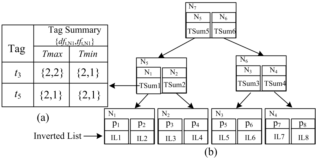
2. The COSS Algorithm
Searching for groups of objects is exponentially harder than searching for one. To handle this, the COSS (Co-spatial Searcher) algorithm uses:
- Shadow Prefix-Tree: A model that materializes neighbor relationships between child nodes, preventing the exhaustive enumeration of all possible subsets.
- Differential Impact Factor (): Based on Bayes theory, this factor ensures that results don't just satisfy the group as a whole while starving one user of their specific needs. It forces a "fair" distribution of tag satisfaction across all sub-queries.
Experiments & Results
The researchers tested their approach against two baselines: FSLU (searching separately then joining) and CISA (centroid-based iterative search).
SOTA Comparison
- Efficiency: COSS consistently showed lower runtime across varying values of (number of results) and different group sizes.
- Scalability: While baseline algorithms saw their runtimes explode as the dataset exceeded 4 million objects, COSS exhibited linear and manageable growth up to 12 million objects.
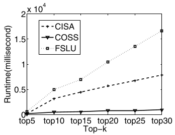
In the figure above, COSS (the bottom line) maintains a significantly lower runtime as the number of requested results (k) increases compared to FSLU and CISA.
Critical Analysis & Conclusion
Takeaway
The TkCoS query represents a more "human" way of searching location data. By treating the group as the primary entity rather than an afterthought of a single search, the authors have created a framework that is both mathematically rigorous (through the use of Vector Space Models for tags) and practically efficient (via the STR-tree).
Limitations & Future Work
While the STR-tree is highly efficient, the current model assumes a static set of tags. In a real-world GeoSN, tags are dynamic and user-generated in real-time. Future iterations might need to incorporate dynamic index updates without full reconstruction. Furthermore, the model uses Euclidean distance; adapting this to road-network distances would increase its practical utility in urban environments.
In conclusion, the Co-spatial Searcher provides a robust foundation for the next generation of collaborative "smart city" applications.