
CrackSense: Turning Citizen Smartphones into High-Precision Road Inspectors
CrackSense: A CrowdSourcing Based Urban Road Crack Detection System
The paper introduces CrackSense, a mobile crowdsourcing-based system for urban road crack detection and damage estimation. It leverages multi-source smartphone sensor data (GPS, accelerometer, magnetometer) and proposes two key algorithms, RCTR and RCDE, to achieve SOTA-level accuracy in crack type recognition (95.8%) and area estimation without specialized hardware.
TL;DR
CrackSense is a novel crowdsourcing system designed to automate urban road maintenance. By leveraging the sensors already in our pockets—GPS, cameras, and accelerometers—it identifies road crack types and calculates their physical damage degree with surprising accuracy (95.8% for type recognition). It solves the "high cost vs. low coverage" dilemma of traditional road inspection by aggregating noisy, multi-angle data from everyday citizens.
Context & Motivation: The Infrastructure Gap
Urban road maintenance is a race against time; an untreated crack quickly becomes a pothole through water penetration and traffic stress. However, professional inspection vehicles (like ARAN) are prohibitively expensive for city-wide, daily deployment.
While mobile crowdsourcing seems like a natural fit, practitioners face a "garbage in, garbage out" problem. Images taken by citizens are often blurry, captured at odd angles, or lack the scale references needed to measure a crack's physical size. The authors of CrackSense argue that the solution lies not just in the image itself, but in the synchronization of visual data with motion sensors.
Methodology: The "Secret Sauce" of Sensor Fusion
1. Data Quality Filtering
Not all crowdsourced images are equal. CrackSense uses a scoring formula that rewards high light intensity and punishes motion blur (detected via 3D accelerometers). This ensures that only the sharpest, most legible images move forward to the analysis phase.
2. RCTR: Solving the Angle Problem
A vertical crack from one perspective might look horizontal from another. To solve this, the researchers developed the Road Crack Type Recognition (RCTR) algorithm. It uses a Coordination Transmission Method to map the "Phone-Centric Coordinate" (PCC) to a "Human-Centric Coordinate" (HCC).
By calculating the rotation matrix from the phone's magnetometer and accelerometer, the system projects the crack orientation onto the real-world road axis obtained from OpenStreetMap.
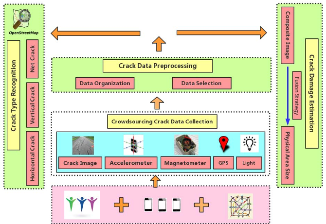 Figure 1: The system architecture showing the pipeline from raw sensor data to damage estimation.
3. RCDE: Measuring Without a Ruler
To estimate the physical area of a crack (Road Crack Damage Estimation - RCDE), the system utilizes the principle of convex mirrors. By calculating the "Object Distance" using the phone's tilt angle and the photographer's height, it maps pixel dimensions to real-world centimeters.
Crucially, it uses SIFT-based image stitching to combine multiple photos of the same crack taken from different viewpoints, creating a "virtual wide-view image" that captures the entire extent of the damage.
Experimental Results: Professional Accuracy from Amateur Photos
The system was tested using 483 data instances collected by 58 volunteers.
- Type Recognition: The system achieved near-perfect scores for "Net Cracks" (100%) and over 93% for linear cracks.
- The Power of Crowds: A key finding was that weighted voting across multiple contributors significantly outperformed any single-image analysis.
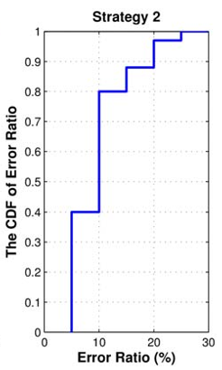 Figure 2: Performance gain of CrackSense's crowdsourcing approach compared to traditional single-source methods.
For area estimation, the "Strategy 1" (calculating individual components and summing them) proved more robust than "Strategy 2" (fusing raw features), highlighting that outcome-level fusion is often more resilient to the noise inherent in crowdsourced datasets.
Critical Insight: Why Does This Matter?
The brilliance of CrackSense isn't in a new AI model, but in its physical-mathematical grounding. By treating the smartphone as a calibrated scientific instrument rather than just a camera, the authors overcome the lack of "ground truth" labels in the wild.
Limitations: The system still relies on the user centering the crack in the frame and requires a baseline for the photographer's height (). Future iterations could potentially automate estimation using ARCore/ARKit depth sensors, further reducing human error.
Conclusion
CrackSense moves us closer to a "Smart City" where infrastructure maintains itself through the collective sensing of its inhabitants. It proves that with the right coordinate transformations and quality filters, the noise of the crowd can be transformed into a high-fidelity map of urban health.