
From Chaos to Cooperation: Why Coordinated Crowdsourcing is the Future of Smart Parking
Crowd-Based Smart Parking: A Case Study for Mobile Crowdsourcing
This paper presents a coordinated mobile crowdsourcing framework for smart parking that integrates with road navigation systems. By transitioning from uncoordinated data sharing to a server-led coordination strategy, the system achieves SOTA performance in reducing cruising time and walking distance without expensive physical infrastructure.
TL;DR
Finding a parking spot in a dense city is a classic "tragedy of the commons." This paper argues that simply sharing data (uncoordinated crowdsourcing) isn't enough—it often makes things worse through herd behavior. By introducing a coordinated navigation strategy that assigns spots and infers data from vehicle sensors, the authors demonstrate a system that slashes cruising time and remains resilient even when most users are "freeriders."
The "Herd Behavior" Trap
Most people assume that "more data equals better results." In mobile crowdsourcing, this is a fallacy. Prior works like Google’s Open Spot allowed users to report vacancies, but this often led to multiple drivers rushing toward the same single spot, only for most to find it occupied upon arrival.
The authors identify a critical insight: Uncoordinated crowdsourcing lacks a global state. Drivers make local decisions that conflict with each other. This "herd behavior" actually results in longer walking distances and higher cruising times than if drivers simply hunted for spots randomly.
Methodology: The Coordinated Pivot
The proposed system moves beyond passive data sharing to active Parking Guidance.
1. Dual-Path Data Acquisition
The system doesn't just rely on drivers clicking buttons. It uses two streams:
- Explicit (Minimalist UI): Instead of asking "how many spots are left?", it asks a simple "Yes/No" question (Q2 in Table 1). Lowering the cognitive load increases the participation rate, which the authors prove is more important than data granularity.
- Implicit (Sensor Inference): By monitoring GPS and speed, the server "knows" a street is full if a car reaches its destination but continues moving at low speed (Cruising).
2. The Coordination Engine
Unlike a standard map, this system acts as a traffic controller.
- Capacity Tracking: It treats road segments as queues. Once a car is directed to a street, the "available capacity" is temporarily decremented to prevent racing.
- Exploration vs. Exploitation: The server directs some drivers to "unknown" blocks. This proactive strategy ensures the parking map stays fresh even in areas with low traffic.
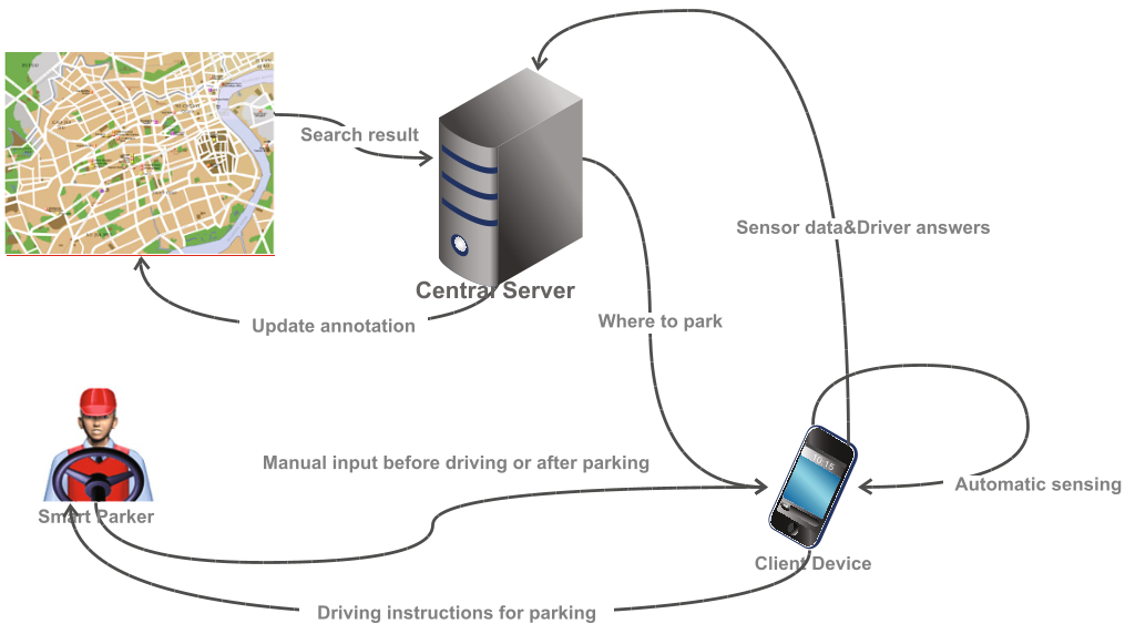 Figure 1: Data flow between Central Servers, Client Devices, and Smart Parkers.
Experimental Results: Efficiency and Resilience
Using a modified SUMO (Simulation of Urban MObility) environment, the authors tested their theories against a 9x9 grid of bidirectional streets.
Coordination vs. Chaos
The results were stark. In uncoordinated scenarios, Smart Parkers actually performed worse than ordinary drivers. However, with coordination, once the participation rate hit 40%, the number of "Perfect Parkers" (those who parked immediately without cruising) soared to over 90%.
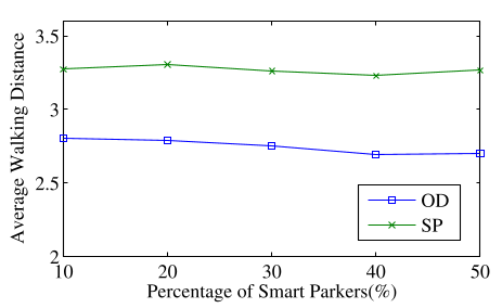 Figure 3 & 4 (Consolidated): Proof that coordination (b) significantly reduces walking distance and cruising time compared to uncoordinated strategies.
The Freerider Paradox
One of the most striking findings is the system's tolerance for Freeriders—users who use the navigation but never report data.
- The system remains stable until the "freerider" ratio exceeds 60%.
- Social Benefit: Even with high freeriding, the total time saved for the entire city increases. The authors argue that designers should tolerate freeriders because they still contribute to the "social good" by reducing overall traffic congestion, provided a 12-15% "core" of contributors remains.
Critical Insight & Conclusion
This paper shifts the focus of Smart City tech from Sensing to Coordination. The takeaway for future developers is clear:
- UI Simplicity is King: A "Yes/No" button is better than a precise numerical sensor if it yields 10x more users.
- Centralization is a Feature, not a Bug: In high-contention resources like parking, a central "orchestrator" is required to prevent collective failure.
- Inference over Input: Use passive sensor data (speed/location) to fill the gaps left by human laziness.
While the paper focuses on parking, this "Coordinated Crowdsourcing" model is a blueprint for everything from EV charging station management to last-mile delivery logistics.