
FLOODIS: Revolutionizing Flood Emergency Response via Cloud-Augmented Crowdsourcing
Coupling crowdsourcing, earth observations, and E-GNSS in a novel flood emergency service in the cloud
The paper introduces FLOODIS, a novel downstream Copernicus emergency service that integrates Earth Observations (EO), crowdsourcing, and cloud computing. It aims to bridge the temporal gap in satellite-based mapping by utilizing real-time User Reports (URs) to provide fast, scalable flood nowcasting and forecasting.
TL;DR
FLOODIS is a highly scalable, cloud-native downstream service designed to solve the "latency gap" in satellite flood monitoring. By coupling Copernicus Earth Observations with crowdsourced mobile reports and EGNOS-augmented GNSS positioning, it delivers real-time flood nowcasts every 30 minutes and forecasts with a 3-day lead time, significantly outpacing traditional satellite-only workflows.
Background: The Latency Bottleneck
In the catastrophic world of flash floods, minutes matter. While the Copernicus Emergency Management Service (EMS) provides world-class satellite imagery, the "activation-to-map" cycle often takes days. This latency makes it difficult for Civil Protection (CP) agencies to manage the immediate tactical evolution of a flood. FLOODIS positions itself as an "accelerator" that fills this information void using ground-level data.
Methodology: The Architecture of Real-Time Awareness
The heart of FLOODIS lies in its Service Oriented Architecture (SOA), which ensures the system can handle massive usage spikes during a disaster while remaining cost-effective during quiet periods.
1. The GEO Gateway & Nowcasting
The GEO Gateway is the "brain" that merges disparate data streams. It pulls official flood delineation maps from Copernicus (via GeoRSS feeds) and fuses them with User Reports (URs).
- Nowcast Strategy: Uses a "lake filling" (0D) model. While computationally simple, it allows the system to update the flood extent every 30 minutes, providing immediate feedback on how water levels are rising in specific streets.
- Forecast Strategy: Employs the LISFLOOD-FP model, integrating river flow data from the European Flood Awareness System (EFAS) and high-resolution Digital Elevation Models (EU-DEM).
2. High-Integrity Positioning (The Augmentation Module)
Standard smartphone GPS is often inaccurate in urban "canyons" or under heavy cloud cover. FLOODIS solves this by implementing an Augmentation Module based on the EGNOS Data Access Service (EDAS). By computing differential corrections and "protection levels" in the cloud, the system ensures that when a citizen reports a water level, the location is both accurate and mathematically verified for integrity.
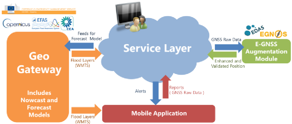 Figure 1: The modular SOA approach allows independent scaling of the Augmentation Module and the GEO Gateway.
On the Ground: The Mobile Interface
The FLOODIS Mobile Application serves dual roles: it is a sensor for the authorities and a lifeline for the citizens. Pro users (Civil Protection) can input precise water levels, while general citizens provide binary status updates and photos. The app uses a hybrid platform (Cordova) to ensure cross-OS compatibility, essential for massive public adoption during crises.
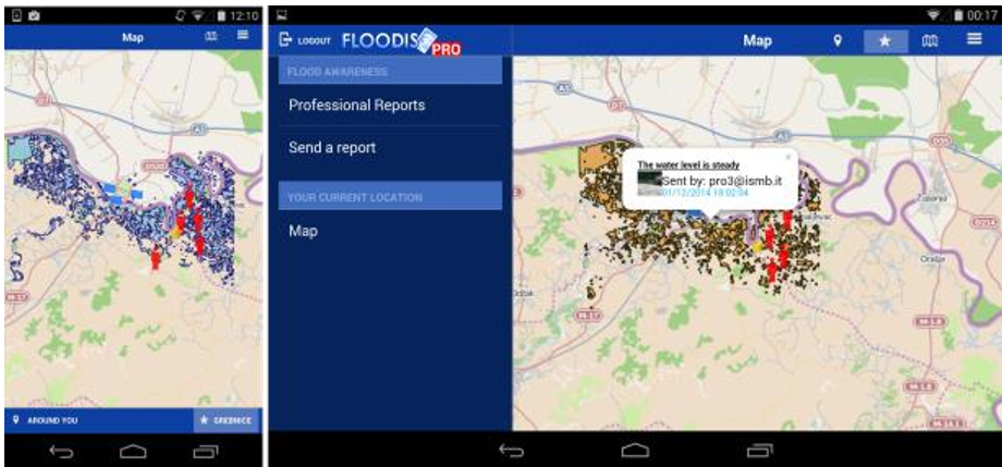 Figure 2: Visual Interface displaying flood layers (blue) and user-contributed icons on a tablet/smartphone.
Critical Analysis & Insights
One of the most striking findings in the paper’s preliminary study is the Social Media Dilemma. While platforms like Twitter offer a wealth of data, the authors found that 75%+ of users disable GPS tagging, and Twitter's metadata stripping makes automated geolocation difficult. This reinforces why a dedicated app like FLOODIS—despite the friction of installation—is necessary for high-stakes emergency management where "verified location" is non-negotiable.
Performance & Social Impact
- Nowcast Update: Every 30 minutes.
- Forecast Frequency: Every 3 hours (3-day lead time).
- Estimated Benefit: Potential to save 18 lives and €70M in a 20-year span for the studied regions.
Conclusion: Toward a Proactive Future
FLOODIS represents a shift from reactive disaster mapping to proactive crisis management. By moving the heavy lifting (GNSS augmentation and hydraulic modeling) to the cloud, it empowers the smartphone in every citizen's pocket to become a critical node in the Copernicus ecosystem.
Future Work: The authors aim to tackle the "fake news" and "data validation" problem in social media integration, which remains the final frontier for fully automated crowdsourced intelligence.