
Crowdsourcing the Green Light: Precise SPaT Estimation via Queue Physics
Crowdsourcing Phase and Timing of Pre-Timed Traffic Signals in the Presence of Queues: Algorithms and Back-End System Architecture
The paper proposes a crowdsourcing-based back-end architecture to estimate Signal Phase and Timing (SPaT) for pre-timed traffic signals using low-frequency probe vehicle data (e.g., public bus GPS). The core method introduces queue-aware algorithms that account for waiting time and dissipation delays, significantly improving estimation accuracy during heavy traffic conditions compared to prior work.
TL;DR
Researchers have developed a system that uses low-frequency GPS data from city buses to predict traffic signal timings. By incorporating a mathematical model of "queue dissipation"—how long it takes for a line of cars to start moving—they can accurately estimate when a light turns green, even during heavy San Francisco rush hour traffic.
Background: The I2V Connectivity Gap
Vehicle-to-Infrastructure (V2I) communication is the backbone of fuel-efficient cruise control and collision avoidance. However, most cities don't share their Traffic Management Center (TMC) data publicly. While crowdsourcing is a popular alternative, previous attempts struggled with a major paradox: the data is most needed during traffic jams, but traffic jams (queues) "pollute" the data because vehicles don't move the moment the light turns green.
The Problem: The "Queue Delay" Distortion
In earlier studies, researchers simply ignored data from vehicles stuck in traffic because it was too hard to tell if a bus stopped because of a red light or because of the five cars in front of it. This lead to:
- Low Data Utilization: Up to 90% of useful samples were discarded.
- Rush Hour Inaccuracy: Signal clocks drift over the day; excluding rush hour data means the system loses track of the "true" timing precisely when it's most needed.
Methodology: Modeling the "Human" Start-up Wave
The core innovation lies in how the authors handle the delay between the start of green () and the moment a vehicle actually starts moving ().
1. Reconstructing Trajectories from Sparse Data
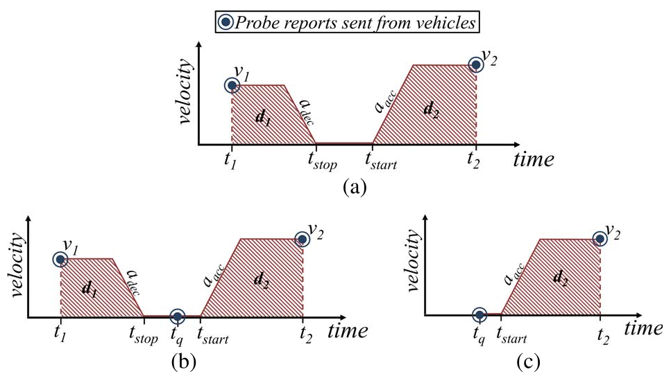
Since buses only report location every 90 seconds (low frequency), the system "interpolates" the movement. It fits sparse GPS points into a velocity-vs-time model that accounts for deceleration, idling in a queue, and acceleration.
2. The Queue Clearance Model
Instead of assuming a constant delay, the authors use a Multiple Linear Regression on historical data to define an exponential headway model: Where:
- is the saturation headway (time between cars).
- is the position in the queue.
- is the extra delay for the first driver's reaction.
By knowing the bus's distance from the stop-bar (position ), the algorithm can "subtract" the expected queue delay to find the exact moment the light changed.
Experiments: Real-World San Francisco Validation
The system was tested using public bus feeds in San Francisco. Unlike simulation-heavy papers, this work confronted real-world "noise" like bus stops and varying street widths.
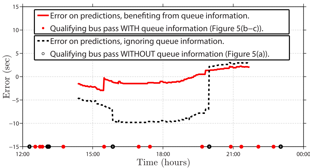
- Green-Initiation Accuracy: During heavy traffic, the "Queue-Aware" model (solid red line in Fig 16) significantly outperformed the "Queue-Ignorant" model (dashed line).
- Robustness: Even with buses arriving only every 5-10 minutes, the moving average filter effectively tracked signal clock drifts and schedule changes (e.g., switching from off-peak to rush-hour timings).
Critical Insight & Conclusion
This paper demonstrates a significant shift from "big data" to "smart physics." Instead of requiring high-frequency 1Hz data from every car on the road, the authors show that with a deep understanding of traffic flow theory, we can extract high-fidelity infrastructure data from low-fidelity public sources.
Limitations
- Pre-timed focus: Currently limited to signals with fixed schedules. Actuated signals (that change based on real-time demand) remain a much harder "moving target."
- Bus Stop Noise: Urban buses stop for passengers, which can mimic a red-light stop. The current filter relies on "cyclic periodicity" to tell the difference, but high-density bus stops still introduce outliers.
Final Takeaway
For developers of Connected Vehicle apps, this provides a blueprint for a "software-only" infrastructure rollout. By deploying these back-end algorithms, a city can enable SPaT features for all citizens using nothing but their existing public transit GPS feed.