
Crowdsourcing-based WiFi Fingerprint Update: Eliminating the Labor of Indoor Localization
Crowdsourcing-based wifi fingerprint update for indoor localization
The paper introduces a crowdsourcing-based system for the automatic generation and maintenance of WiFi fingerprint databases for indoor localization. It leverages smartphone inertial sensors and a novel Ratio-based Map Matching (RMM) algorithm to bind WiFi signals to geographical coordinates without manual site surveys.
TL;DR
Indoor localization is essential, but the gold-standard method—WiFi Fingerprinting—is notoriously difficult to maintain because it requires manual labor to map signals to every square meter. This paper introduces a crowdsourcing framework that uses the sensors already in your pocket. By focusing on the ratio of steps rather than absolute distance, the system can automatically build and update a signal map that is as accurate as professional manual surveys.
The Motivation: The "Maintenance Nightmare" of WiFi Maps
WiFi fingerprinting works like a digital signature: your phone sees a specific set of Signal Strengths (RSS) from various Access Points (APs) and matches them to a database. However, this database is fragile. If a shop moves or an AP is replaced, the map breaks.
Prior "Crowdsourcing" attempts often failed because:
- User Error: Users shouldn't have to manually "check-in" to confirm their location.
- Sensor Drift: Using Pedestrian Dead Reckoning (PDR) to estimate distance (meters) leads to cumulative error. If your stride length is off by 10%, after 100 steps, you are "ghosting" through a wall on the digital map.
The authors' insight? Don't measure distance; measure ratios.
Methodology: The Power of Ratios and HMM
The system follows a four-step pipeline: Step Detection HMM Modeling RMM Matching DB Update.
1. Action Recognition
Using the smartphone's accelerometer and gyroscope, the system identifies "Step Sequences." It detects peaks in acceleration to count steps and uses angular velocity to identify turns (Normal turns vs. U-turns).
2. The RMM Algorithm (The Core Innovation)
Instead of matching a path based on "Walk 10 meters, turn south," the Ratio-based Map Matching (RMM) algorithm matches based on "The second segment was 1.5x longer than the first."
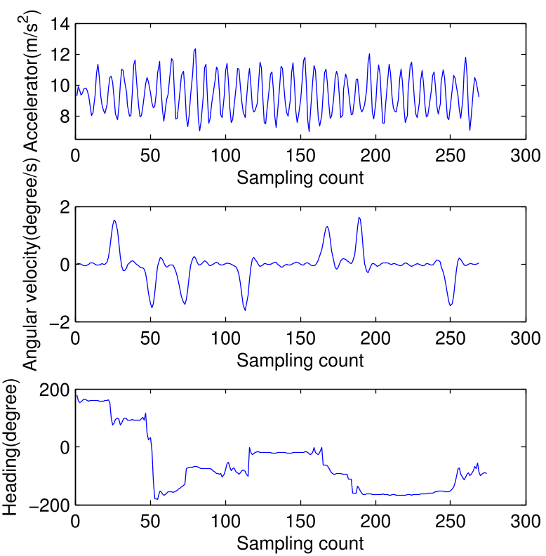 Figure 1: The Action Recognition flow used to generate step sequences from raw sensor data.
By using ratios (), the system offsets systemic errors caused by different walking speeds or different device sensitivities. This sequence is fed into a Hidden Markov Model (HMM) where map nodes are "hidden states" and the step ratios are "observable states."
3. Path Tree Search
The algorithm builds a Path Tree. It discards branches where the "Emission Probability" is low—meaning the user's walked ratio doesn't fit the map's geometry. This allows the system to find the correct path even without knowing where the user started.
Experimental Results: RMM vs. Traditional PDR
The researchers tested the system in a 50m x 50m teaching building.
- Accuracy vs. Sequence Length: As shown in the data, once a user takes more than 5 turns, the RMM algorithm significantly outperforms traditional PDR.
- Database Convergence: After approximately 60 users walk a path, the auto-generated WiFi map becomes as reliable as one measured by a professional.
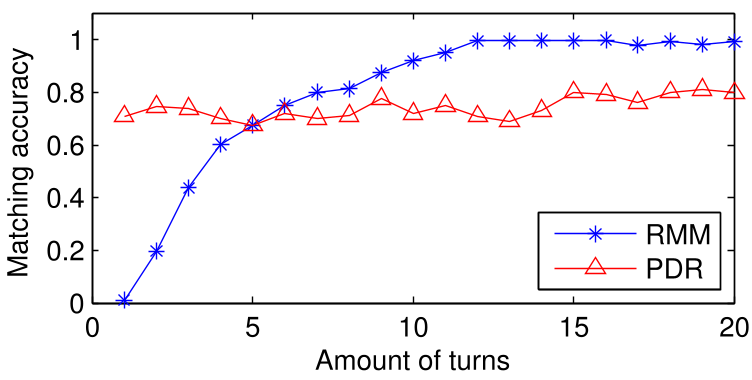 Figure 2: Comparison showing that RMM accuracy improves with sequence length, eventually surpassing distance-based PDR.
Critical Analysis & Conclusion
Takeaway
The shift from absolute measurements to relative ratios is a brilliant "heuristic hack" for indoor localization. It solves the heterogeneity problem (different people, different phones) that has plagued crowdsourced PDR for a decade.
Limitations
- The "Turn" Dependency: The system works best in corridor-heavy environments (like offices or malls). In a wide-open hall without turns, there are no "nodes" to trigger the ratio calculation.
- Initial Map Requirement: The system still requires an architectural map (road network) to be digitized beforehand.
Future Outlook
This work paves the way for "Self-Healing" indoor maps. Imagine a mall navigation app that grows more accurate the more people use it, automatically detecting when a router has been moved simply by noticing a shift in the crowdsourced signal ratios.
Senior Editor's Note: This paper is a classic example of using mathematical constraints (Map Topology) to overcome hardware limitations (Sensor Noise). It remains a foundational concept for anyone building scalable LBS (Location Based Services).