
Order out of Chaos: The Rise of Crowdsourced Indoor Localization
From one to crowd: a survey on crowdsourcing-based wireless indoor localization
This survey explores the evolution of wireless indoor localization, focusing on the transition from expert-led systems to crowdsourcing-based paradigms. It proposes a three-layer framework (Signal, Integration, and Crowdsourcing) and details how integrating chaotic multi-modal signals—RF, ambient, visual, and motion—achieves state-of-the-art accuracy in GNSS-denied environments.
TL;DR
While GPS dominates the outdoors, indoor navigation remains a fragmented "wild west" due to complex signal interference. This survey presents a systematic shift from dedicated infrastructure to crowdsourcing, utilizing the sensors already in our pockets to turn "chaotic" environmental noise into a high-precision positioning engine.
Problem & Motivation: The GNSS-Denied Challenge
Indoor spaces are fundamentally hostile to traditional positioning. Walls cause multipath fading (where signals bounce and interfere with themselves), and the lack of a "global clock" like GPS makes timing-based ranging difficult.
Historically, achieving 1-meter accuracy required "Fingerprinting": an expert walking through a building to manually map WiFi signal strengths at every coordinate. This is a maintenance nightmare. The authors argue that the only way forward is to harness the crowd—using the movement and sensor data of ordinary building occupants to build these maps organically.
Methodology: The Three-Layer Architecture
The paper organizes the technical landscape into a logical hierarchy that moves from raw physics to social collaboration.
1. The Signal Layer: Beyond Simple WiFi
The survey categorizes signals based on their "physics":
- WiFi RSSI vs. CSI: While RSSI (strength) is noisy, CSI (Channel State Information) captures the subcarrier-level phase and amplitude, allowing for centimeter-level ranging.
- Magnetic & Acoustic: The subtle distortions in the Earth's magnetic field caused by steel beams act as a unique, permanent "fingerprint."
- Visual Signals: Moving from 2D images to 3D Point Clouds (as seen in Google Tango/Lidar) provides structural anchors that are immune to lighting changes.
2. The Integration Layer: Fusing Intelligence
This is where the magic happens. The writers describe how a single user's walk-path can be corrected using "landmarks."
- Walk-Path Merging: By finding "encounters" or overlapping signal signatures, the system can stitch together thousands of individual, noisy trajectories into a coherent indoor map.
- PDR & Ranging Fusion: Pedestrian Dead Reckoning (using accelerometers) keeps track of relative movement, while occasional RF ranging anchors the user to an absolute coordinate.
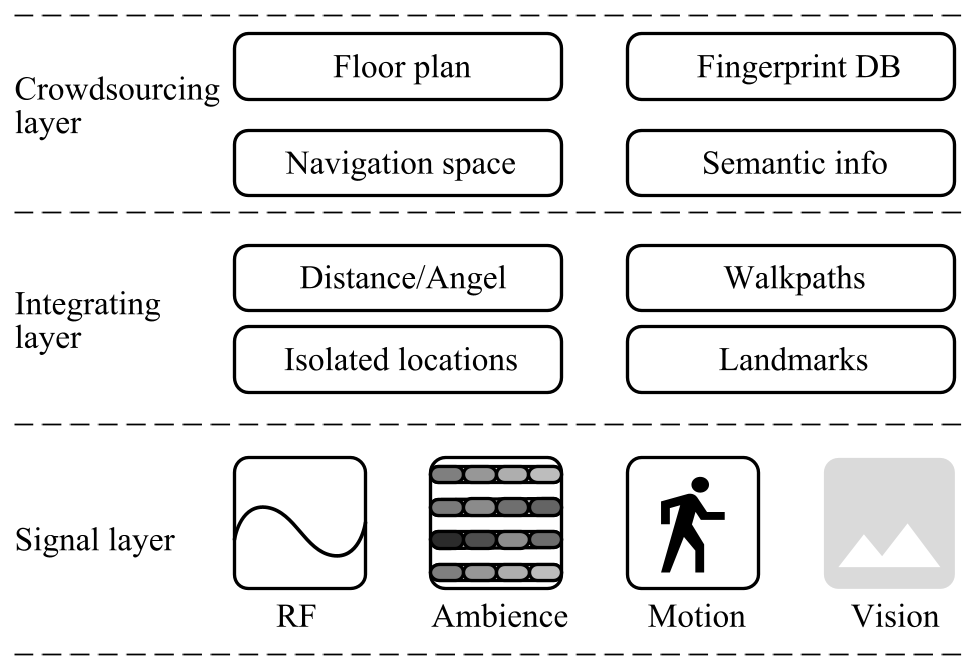 Fig 1: The Three-Layer Framework for Crowdsourcing-based Localization.
Experiments & Results: Comparing the Tech
The survey provides a critical comparison of how different signals perform in the real world.
- Accuracy vs. Infrastructure: While Visible Light (VLC) and WiFi-CSI offer the highest accuracy (<0.5m), they require specific hardware.
- The Robustness Trade-off: Visual signals are high-complexity but offer high spatial distinctiveness. In contrast, motion signals (Dead Reckoning) are low-cost but suffer from cumulative error (drift).
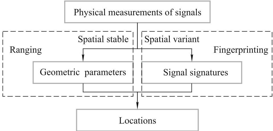 Fig 2: The trade-off between spatial stability and signal variety in localization methodology.
Critical Insight: The "Long Tail" and Semantic Future
One of the survey's most profound observations is the "long-tail effect" in localization: even the best systems fail in specific corners or "dead zones" where Line-of-Sight (LoS) is blocked.
The authors suggest that the next frontier isn't just better math—it's Semantic Localization. Instead of telling a user they are at (x: 45.2, y: 12.1), the system should recognize they are "in front of the Starbucks logo" or "near the exit of the conference hall." By mining images and interactions, crowdsourced systems can bridge the gap between "coordinates" and "context."
Summary & Limitations
Takeaway: Wireless localization is shifting from a hardware problem to a data-fusion problem. Crowdsourcing eliminates the "site survey" cost, making ubiquitous indoor LBS (Location Based Services) viable.
Limitations:
- Quality Control: How do we filter out "poisoned" data from malicious participants?
- Incentives: Why should a user let a system record their sensor data? This remains a social-technical hurdle.
As we move toward a world of AR glasses and wearable sensors, the "one to crowd" paradigm will likely become the standard for how we navigate our indoor world.