
DCPGS: Why Your Social Network Defines the Places You Group Together
Density-Based Place Clustering Using Geo-Social Network Data
This paper introduces the Density-based Clustering Places in Geo-Social Networks (DCPGS) model, which groups geographical locations by integrating spatial proximity with social network ties and temporal check-in dynamics. Built upon an extension of DBSCAN, it achieves superior cluster coherence by identifying geo-socially connected regions that traditional spatial-only methods overlook.
TL;DR
The paper introduces DCPGS, a density-based clustering framework that moves beyond simple GPS coordinates. By analyzing the "who" and "when" behind check-ins, it identifies clusters of places that aren't just physically close, but socially and temporally linked. This approach solves the limitations of classic DBSCAN by discovering socially tight but spatially sparse regions.
Contextual Positioning: Beyond the Euclidean Trap
In the world of urban planning and digital marketing, knowing that two restaurants are 50 meters apart is useful, but knowing that the same social circle frequents both at the same time of day is a goldmine. The fundamental limitation of prior work is the Euclidean Bias—the assumption that geographic proximity is the only proxy for similarity. DCPGS breaks this by treating a "place" as a node in a combined spatio-temporal-social manifold.
Problem & Motivation: The "Barrier" and "Loose" Problems
Standard spatial clustering suffers from two major failures:
- The Hidden Barrier: Two points might be 10 meters apart but separated by a river or a wall. If the users visiting them never interact, they shouldn't be in the same cluster.
- Spatially Loose Cohesion: A series of niche hobby shops might be spread across a district (spatially sparse) but visited exclusively by a tight-knit community. DBSCAN would label these as "noise/outliers," whereas DCPGS recognizes them as a functional cluster.
Methodology: The Geo-Social Distance
The core innovation is the weighting of spatial and social distances into a unified metric:
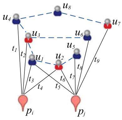
The Social Distance () is particularly clever. It doesn't just look for user overlap; it looks for Direct Friendships. If User A visits Place 1 and their friend User B visits Place 2, those places are socially "brought closer."
Adding the "When": Temporal Integration
The authors suggest three ways to handle the arrow of time:
- History-Frames: Snapshots of how clusters evolve (e.g., NYC in 2010 vs 2011).
- Damping Window: Giving more weight to recent behavior, making the model sensitive to current trends.
- Temporally Contributing Users: Only counting social links if the visits occurred within a specific window (e.g., the same week).
Experiments: Superior Social Coherence
The authors tested DCPGS on massive datasets from Gowalla and Brightkite.
Visual Evidence
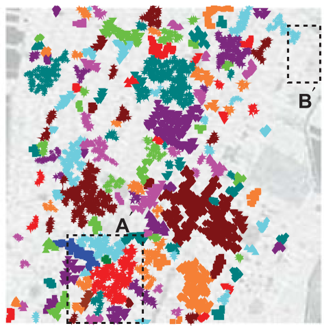
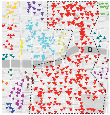
As shown in the Manhattan case study, DCPGS manages to find clusters with "Fuzzy Boundaries." It allows for the reality that two different social groups might inhabit the same geographic space without merging them into a single blob—a feat DBSCAN cannot achieve.
Quantitative Edge: Social Entropy
To prove that these clusters actually mean something, the authors used Social Entropy. A lower entropy means the visitors to a cluster are more likely to belong to the same community. The results consistently showed that including temporal and social data reduced entropy compared to pure spatial methods.
Critical Insight & Conclusion
DCPGS effectively proves that Density is no longer just about points per square meter; it's about social activity per square meter.
Takeaways:
- For Marketers: Collaborative promotion should target geo-social clusters, not just "people nearby."
- For Urban Planners: Identifying "socially separated" adjacent clusters can highlight lack of accessibility or social segregation.
- Limitations: The model relies on explicit friendship graphs, which are increasingly harder to access due to privacy regulations. Future work might need to infer "latent" social ties from co-occurrence alone.
Ultimately, this work serves as a foundational bridge between traditional GIS (Geographic Information Systems) and Social Network Analysis.