
Evidential Location Estimation: Mapping Twitter Events Through the Fog of Uncertainty
Evidential location estimation for events detected in Twitter
This paper proposes an Evidential Location Estimation method for events detected in Twitter using Dempster-Shafer Theory (DST). By fusing multi-source evidence including GPS coordinates, user profile locations, and textual content, it successfully estimates event locations (e.g., earthquake epicenters) even amidst high data uncertainty.
TL;DR
Researchers have developed a robust method to pinpoint the geographical origin of real-world events (like earthquakes) using Twitter data. By applying Dempster-Shafer Theory (DST), they combine unreliable signals—GPS tags, user profiles, and text—while filtering out the "noise" created by high-population centers to accurately locate events.
The "Istanbul Problem": Why Location Estimation is Hard
In the world of social media analytics, Twitter acts as a massive distributed sensor network. However, these "sensors" are incredibly noisy. If an earthquake happens in a small village, the handful of tweets from that village is often drowned out by thousands of people in a distant metropolis (like Istanbul) talking about the event after seeing it on the news.
Existing methods often fail because:
- Data Sparsity: Less than 1% of tweets may have high-precision GPS.
- Uncertainty: A user saying they live in "Ankara" might be tweeting from a vacation in "Mugla."
- Population Bias: Raw tweet volume correlates with population, not necessarily the event's epicenter.
Methodology: The Power of Evidential Reasoning
The core insight of this paper is treating location estimation not as a simple probability problem, but as Evidential Reasoning. Instead of asking "What is the probability of location X?", the authors use DST to ask "What is our belief in location X based on our ignorance of the data?"
1. Multi-Source Evidence Fusion
The model extracts three types of evidence:
- : Hard evidence from device coordinates.
- : Soft evidence from profile metadata.
- : Semantic evidence from place names mentioned in the text.
2. Normalization via "Presence Tweets"
To cancel out the population bias, the authors proposed a clever normalization technique. They analyzed "presence tweets"—everyday chatter like "good morning" or "happy birthday"—to establish a baseline for Twitter activity in each city. If a city usually produces 20% of Turkey's tweets but suddenly produces 30% during an event, that delta is a much stronger signal than a city that always produces 50%.
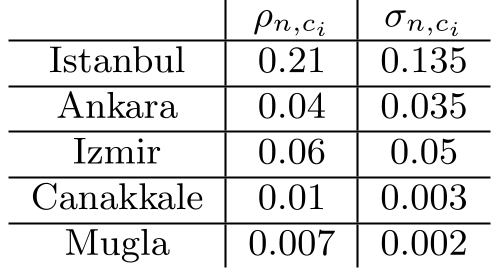 Table: Establishing the "User Density" baseline for different cities.
Experiments: Real-World Earthquakes
The authors tested their system on two earthquakes in Turkey (Canakkale and Mugla).
In the Canakkale earthquake, the raw GPS data was heavily clustered around Istanbul (due to its massive population). Without the authors' evidential reasoning and normalization, an observer might mistakenly think the earthquake happened in the capital.
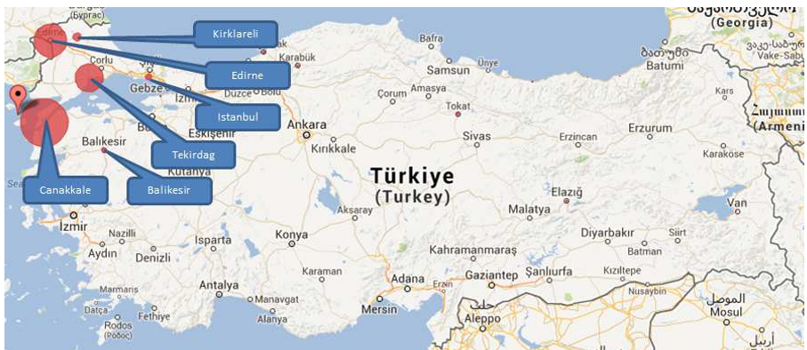 Figure 1: Raw GPS distribution showing heavy bias toward high-population areas.
By applying DST, the model assigned the highest Belief (Bel) value to Canakkale. The "circles" in the results map visualized this belief, showing that despite fewer total tweets, the evidence quality pointed directly to the actual epicenter.
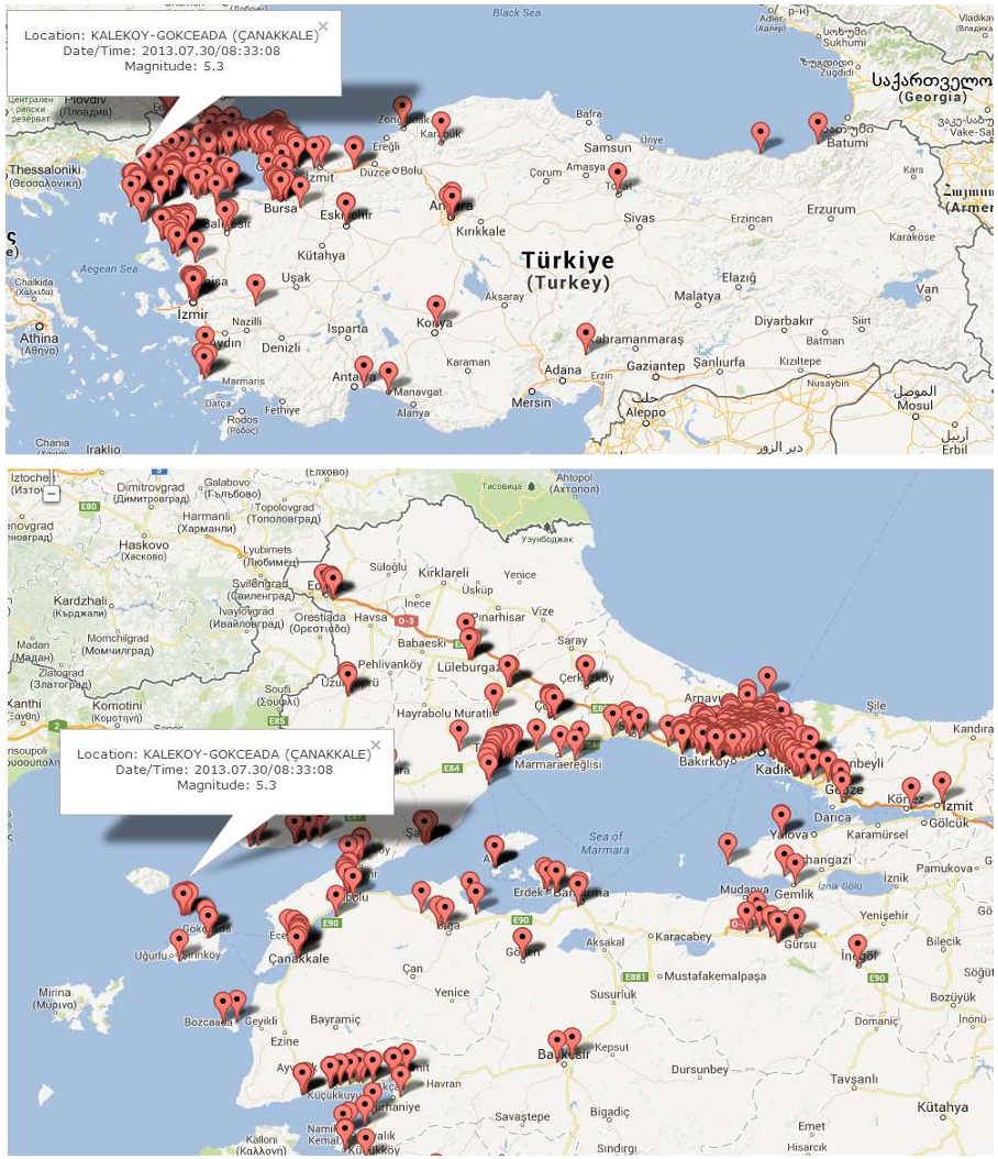 Figure 2: Final belief values. Larger circles indicate higher confidence in the event occurring at that location.
Critical Insight & Conclusion
The brilliance of this work lies in its embrace of Ignorance. Standard Bayesian models struggle when data is missing; DST, however, allows "missing data" to be represented as a valid state.
Key Takeaways:
- Normalizing for "Baseline Chatter" is the only way to find events in low-population areas.
- Collective Intelligence works: Combining three "weak" indicators (GPS, Profile, Text) leads to one "strong" evidential conclusion.
- Future Impact: While this study focused on cities, the framework is granular. It could eventually be used for hyper-local crisis management (e.g., locating street-level flooding or fire) by swapping the "City" frame of discernment for a "Grid" or "Neighborhood" frame.
While the 140-character limit of 2013-era Twitter has changed, the fundamental problem of geospatial uncertainty in social media remains a critical frontier for disaster response and situation awareness.