
How Fashionable is Each Street? Mapping Urban "Vibes" via Social Media and MRF
How fashionable is each street?: quantifying road characteristics using social media
This paper introduces a two-stage framework to quantify qualitative road characteristics (e.g., "fashionable," "lively") by analyzing geo-tagged social media posts and road network structures. It combines Latent Dirichlet Allocation (LDA) for POI profiling and Markov Random Fields (MRF) for spatial characteristic propagation across road segments, achieving state-of-the-art performance in subjective road ranking.
TL;DR
Navigating a city isn't just about the shortest path; sometimes, it's about finding the most "fashionable" or "tranquil" route. This paper presents a novel two-stage system that extracts qualitative characteristics from geo-tagged social media (Twitter/Flickr) and maps them onto road networks using Markov Random Fields (MRF). By bridging the gap between what people say about POIs and the actual roads connecting them, the authors enable a "keyword-searchable" city.
The "Qualitative Gap" in Navigation
When you search for a route on Google Maps, you get the fastest or the least congested path. But what if you want a "lively" atmosphere or a "beautiful" walk?
The challenge is twofold:
- Data Sparsity: Roads aren't usually described in posts; buildings (POIs) are.
- Subjectivity: "Fashionable" is hard to define with sensors or simple metadata.
Previous attempts either relied on expensive crowdsourcing or focused on very narrow traits (e.g., just "safety"). This work aims for a comprehensive, low-cost solution by leveraging the collective intelligence of social media.
Methodology: From POI Chatter to Road DNA
The authors argue that a road's character is a reflection of the venues (POIs) it hosts. Their approach unfolds in two key phases:
1. Topic Modeling (LDA) on POIs
Short social media posts are too noisy for standard LDA. The authors aggregate posts by POI to creates "documents" of sufficient length.
- Input: 1.5 million geo-tagged posts.
- Output: A topic distribution () for every POI and a word distribution () for every topic.
- Insight: This identifies that a certain area is "about" high-end fashion, while another is "about" nightlife.
2. Markov Random Field (MRF) for Propagation
This is the "secret sauce." Because many roads have no nearby POIs, the model uses an MRF to "smooth" and propagate characteristics across the road network.
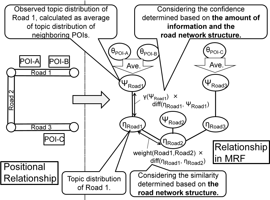
The cost function for the MRF balances three factors:
- Observed POI Data: Staying true to the topics derived from nearby venues.
- Network Structure: Similar types of roads (e.g., two residential streets) are more likely to share traits than a highway and a side-alley.
- Confidence: Roads with more data (more posts) are weighted more heavily in the optimization.
Experimental Results: Can AI Find "Fashion"?
The team tested their model across three iconic Tokyo districts: Asakusa, Shinjuku, and Shibuya.
| Method | Precision @ 5 | nDCG |
|---|---|---|
| BM25 (Keyword Match) | ~0.1 | ~0.2 |
| LDA-MRFAR (Proposed) | ~0.32 | ~0.58 |
The results were striking. The proposed method (LDA-MRFAR) significantly outperformed standard information retrieval techniques. It didn't just find roads with the word "fashion" in a tweet; it identified "fashionable" roads by understanding that people were talking about "Harajuku," "Cat Street," and "boutiques" nearby.
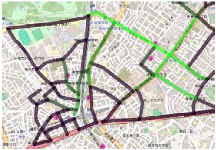 In the map above, brighter green indicates a higher "fashionable" score for the road segment in Shibuya.
Critical Analysis & Real-World Value
The study proves that road networks act as a manifold for cultural information. However, there are limitations:
- Topic Lag: Social media reflects popular sentiment, which might miss niche or emerging vibes.
- Context Dependency: "Famous spots" are hard to quantify because "famous" is a relative term that depends heavily on the user's background.
Why it matters: This technology is the backbone for the next generation of "Discovery Engines." Instead of just getting from point A to B, we can now ask our navigation systems to "take the scenic, quiet way home" or "find a route with lots of cafes and a lively atmosphere."
Conclusion
By treating the city as a graph of social interactions rather than just a collection of coordinates, this research provides a scalable way to digitize the subjective "soul" of our streets.