
GPS Estimation: Scaling Visual Localization with Hierarchical Indexing
GPS Estimation for Places of Interest From Social Users' Uploaded Photos
The paper introduces an unsupervised image GPS location estimation approach using a hierarchical structure for global feature clustering and local feature refinement. By leveraging an offline inverted file structure for representative images, the method achieves SOTA performance in accuracy and computational efficiency for large-scale geo-tagged datasets.
TL;DR
Determining where a photo was taken based solely on pixels is a monumental task. This paper presents a hierarchical, unsupervised framework that clusters millions of geo-tagged images to provide near-instantaneous GPS estimation. By combining global scene descriptors with local feature refinement and an efficient inverted file structure, the authors achieve high accuracy while reducing computational costs by several orders of magnitude compared to traditional K-NN search.
The Scalability Bottleneck in Geo-Tagging
The explosion of social media has provided us with billions of geo-tagged images. However, the "brute force" approach—comparing a query image against a massive database—is a computational nightmare. Prior work like IM2GPS proved that global features could work, but they often lack the precision to distinguish between two different churches with similar architecture. Conversely, local feature matching (like SIFT) is precise but too slow for large-scale applications.
The authors identify a critical insight: visual similarity does not always mean geographic proximity. They argue for a system that first narrows down the "visual vibe" of an image before performing expensive local verification on a tiny subset of candidates.
Methodology: The Power of Hierarchy
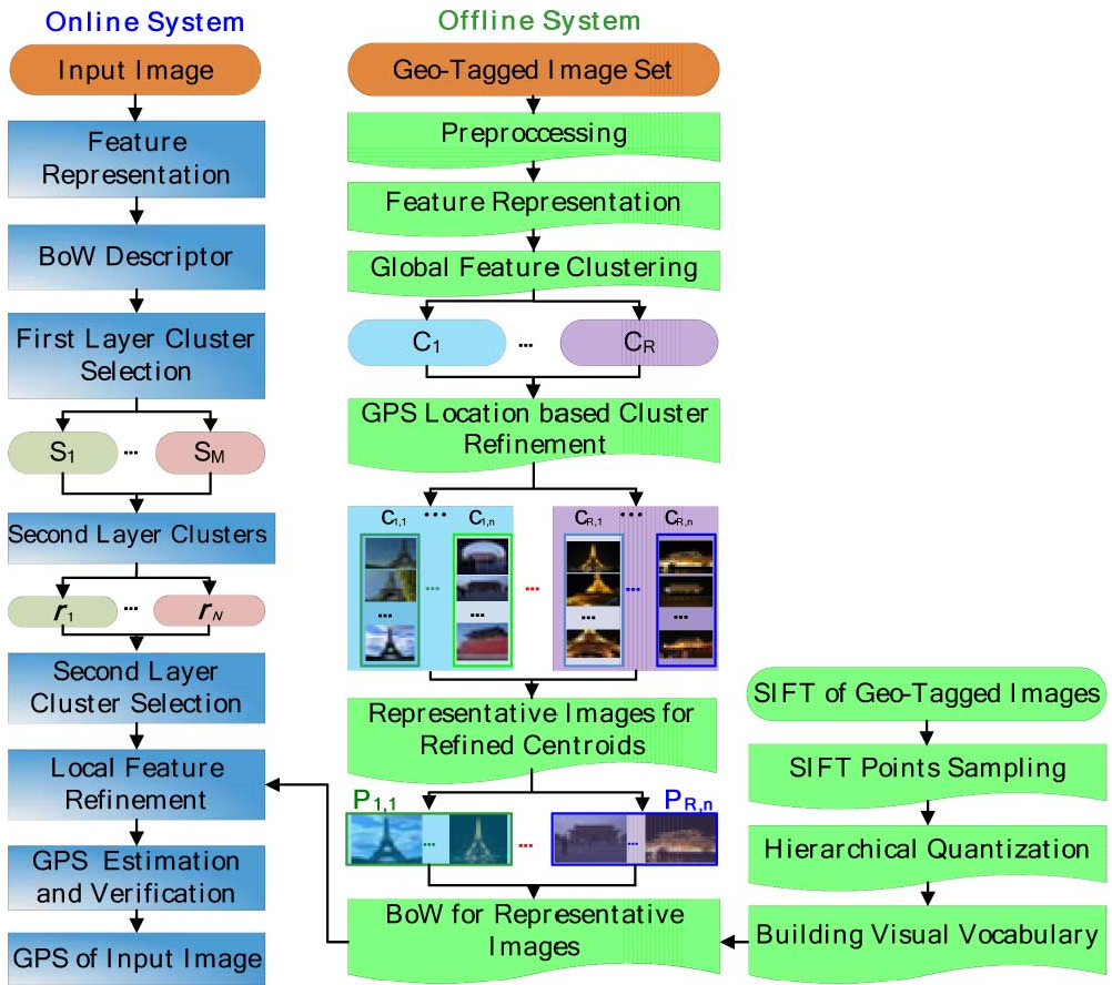
The core of the paper is the Offline-Online split, designed to shift the heavy lifting away from the user's query time.
1. Offline System: Building the Index
- Preprocessing: Filtering out "noisy" images (e.g., pure blue sky or dark photos) that lack distinctive features.
- Global Features: Using a 215-D vector composed of Color Moments (CM) and Hierarchical Wavelet Packet (HWVP) to capture the broad essence of the scene.
- Hierarchical Clustering: Images are first clustered into categories (e.g., daytime vs. night, modern vs. ancient). These are further refined into GPS-specific centroids.
- Representative Image Selection: Instead of keeping every grainy photo of the Eiffel Tower, the system selects "Representative Images" that capture diverse viewpoints while stripping out outliers with faulty GPS tags.
2. Online System: The Fast Search
When a user uploads a photo, the system performs a two-step refinement:
- Coarse Selection: The image is mapped to the top global clusters.
- Local Refinement: The system uses an Inverted File Structure (IFS) to match SIFT features only within the selected candidate clusters. This is the secret sauce that reduces the search space from millions to thousands.
Experimental Validation
The researchers tested their approach on several datasets, including the massive GOLDEN dataset (5.2 million images).
SOTA Comparison
The proposed IFS (Inverted File Structure) method achieved a balance between precision and speed that was previously unattainable:
- Accuracy: On the COREL5000 dataset, the method reached 91% accuracy, dwarfing IM2GPS's 45.98%.
- Speed: The most striking result is the computational cost. On the GOLD dataset, IM2GPS took 64,927ms per query, while the proposed IFS method took only 0.16ms.

The Importance of Hierarchy
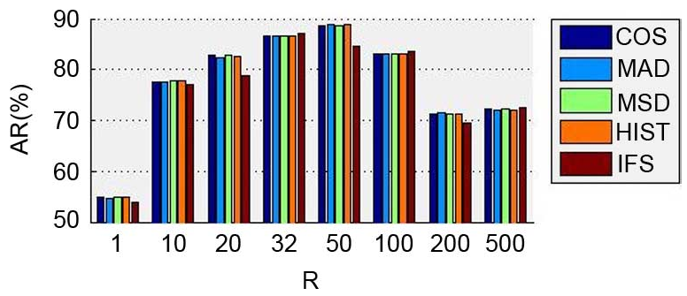
As shown in Fig. 3 below, the number of first-layer clusters () significantly impacts performance. Without clustering (), the system is less accurate. The sweet spot was found around to , where the system efficiently separates unrelated visual scenes.
Deep Insight: Why Representative Images Matter
One of the paper's most innovative points is the Representative Image Selection Algorithm. By using local feature matching to find the most "central" and "diverse" views of a location, the system effectively denoises social media data. This process ensures that the database isn't cluttered with redundant images, which not only speeds up the search but also prevents "false matches" from outlier images that were tagged incorrectly by users.
Critical Analysis & Conclusion
While the system excels at landmarks (like the Eiffel Tower or the Forbidden City), it struggles with natural landscapes that change significantly with seasons or weather (e.g., Mount Fuji covered in flowers).
Takeaway: This work provides a masterclass in how to combine "classic" computer vision techniques (SIFT, K-means) with smart indexing structures (IFS) to solve a modern big-data problem. For industry professionals, it highlights that data organization is often as important as the feature extraction itself when aiming for real-time performance.
Future Outlook
The next logical step for this research would be the integration of Deep Feature Embeddings. While handcrafted features (Color Moments) were state-of-the-art during this study, modern CNN or Transformer-based embeddings could potentially handle the "changing background" problem (landscapes) more robustly.