
Homomorphic Proximity: Secure Distance Computation in Geosocial Networks
Homomorphic proximity computation in geosocial networks
The paper introduces two novel methods for secure proximity computation in Geosocial Networks using the NLV2011 Somewhat Homomorphic Encryption (SWHE) scheme. It enables location-based services (e.g., "friend-nearby" alerts) to operate directly on encrypted coordinates, achieving State-of-the-Art privacy by ensuring the service provider never learns the user's actual location.
TL;DR
In the era of pervasive mobile tracking, this paper presents a practical breakthrough: calculating the distance between two friends in a social network without the server ever knowing where they are. Using Somewhat Homomorphic Encryption (SWHE), the researchers demonstrate two methods—Direct Euclidean estimation and Geo-hashing—that allow for secure, privacy-preserving proximity checks on platforms ranging from low-power Raspberry Pis to high-performance Amazon EC2 instances.
Problem & Motivation: The Location Privacy Paradox
Geosocial apps like Facebook and Tinder offer immense utility by notifying us when friends are nearby. However, this utility comes at a steep price: we must surrender our real-time GPS coordinates to service providers.
Prior attempts to solve this (like "anonymity" or "obfuscation") often fall short because:
- Trust Issues: They usually require a "trusted" server or a dense network of nearby peers.
- Accuracy vs. Privacy: Adding noise (Differential Privacy) can make "nearby" alerts unreliable.
- Insider Threats: Plaintext data in a database is vulnerable to leaks and subpoenas.
The authors' insight is to use Homomorphic Encryption (HE)—the "Holy Grail" of cryptography—which allows a server to perform mathematical operations (like addition and multiplication) on ciphertexts, producing an encrypted result that only the user can decrypt.
Methodology: The Core Architecture
The paper focuses on the NLV2011 scheme based on Ring-Learning With Errors (Ring-LWE). They propose two distinct pathways for proximity:
1. The Euclidean UTM Approach
To avoid the complex Haversine formula (which involves trigonometry incompatible with HE's polynomial nature), the authors map GPS data to the UTM (Universal Transverse Mercator) coordinate system.
- Insight: In UTM, distance is essentially Euclidean.
- Logic: The server computes on encrypted values.
- Optimization: They utilize the Chinese Remainder Theorem (CRT) to handle large integer arithmetic efficiently.
2. The Geo-hashing (Z-Order Curve) Approach
For cases where a "Bounding Box" is better than a precise number, they use Geo-hashing. This converts 2D coordinates into a 1D bitstring (quadkeys).
- The Intuition: The longer the common prefix between two bitstrings, the closer the users are.
- The Challenge: Identifying a common prefix homomorphically requires deep multiplicative circuits. The authors developed a prefix mask refinement process using XNOR and sequential multiplications.
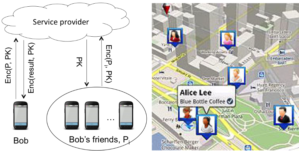 Figure 1: High-level workflow of the privacy-preserving geosocial application.
Experiments & Results: Is it Practical?
The authors didn't just write theory; they tested it on hardware ranging from ARM-based mobile boards to Intel Xeon cloud servers.
Key Performance Metrics:
- Euclidean Method: extremely fast, completing in 0.21 seconds on Amazon EC2. This is fast enough for real-time social notifications.
- Geo-hashing Method: Significantly slower (approx. 232 seconds on EC2) due to the 43 levels of homomorphic multiplication required to mask the prefix.
- Hardware Scaling: While a Raspberry Pi struggled with complex multiplications, the ODROID-XU3 (representing a modern smartphone) proved that these computations are becoming feasible for edge devices.
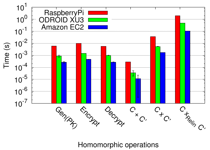 Figure 2: Computation time comparison for Euclidean distance and common HE operations.
Critical Analysis & Conclusion
The Takeaway
This work demonstrates that Somewhat Homomorphic Encryption is a viable candidate for protecting highly sensitive spatial metadata. The Euclidean approach is ready for deployment, while the Geo-hashing approach offers a fascinating "privacy control" feature—users can choose to reveal only their city or their street by masking their own bitstrings before encryption.
Limitations & Future Work
- Computation Overhead: The Geo-hashing method's latency is a bottleneck. The authors suggest moving toward SIMD (Single-Instruction-Multiple-Data) to parallelize bitwise operations.
- Key Management: The current prototype uses a single-key system. Future iterations must support Multi-key HE to allow users to interact without sharing the same secret key.
By bridging the gap between high-level cryptography and mobile computing, this paper paves the way for a new generation of "Zero-Knowledge" location services.