
Beyond Color: Boosting High-Precision Agriculture with Decision Tree Ensembles
Improved Machine Learning Methodology for High Precision Agriculture
This paper introduces a high-precision agriculture framework centered on vineyard detection using UAV-captured hyperspectral imagery. It proposes an "Improved Machine Learning Methodology" utilizing a Decision Tree Ensemble (DTE) to classify agricultural terrain into vineyard, road, or other categories.
TL;DR
Precision agriculture is evolving from simple satellite monitoring to autonomous drone-based intervention. This paper demonstrates that by moving beyond simple color intensity analysis to a Decision Tree Ensemble (DTE) focused on texture and statistical features, vineyard detection accuracy can be boosted from 89.6% to 94.27%. This improvement is critical for the next generation of UAVs that must navigate and treat specific crop zones autonomously.
Background Positioning
While satellite mapping (Landsat) has been the standard for decades, its resolution is insufficient for the granular task of individual vineyard management. This work positions itself as a transition from Pixel-Based-Classification (PBC) to a more sophisticated Object-Oriented Classification (OOC), specifically tailored for the difficult topographies of Valais, Switzerland.
The "Intensity" Trap: Problem & Motivation
Many traditional agricultural models rely on spectral signatures—essentially, how "green" or "intense" a pixel is. However, in a vineyard, this fails because:
- Mixed Pixels: Soil, metal stakes, and shadows blend with the vines.
- Context Blindness: PBC cannot distinguish between a green road-side weed and a grape vine.
- Topography: Slopes change how light reflects, confusing simple intensity sensors.
The authors' insight was to shift the unit of analysis from a single pixel to a 30x33 pixel tile, allowing the model to "see" textures and spatial patterns rather than just raw color.
Methodology: The Decision Tree Ensemble (DTE)
The core of the "Improved Methodology" lies in its feature engineering. Instead of tossing raw pixels into a black box, the researchers extracted 86 specific features categorized into three domains:
- First-Order Statistics: Simple metrics like Mean, Variance, and Kurtosis.
- Tamura Features: Measuring human-perceptible textures like Granularity and Directionality.
- Haralick Features: Leveraging Gray-Level Co-occurrence Matrices (GLCM) to capture spatial relationships between pixel intensities.
Architecture & Refinement
To prevent overfitting and ensure real-time viability on drone hardware, the authors used Backward Elimination. This pruned the 86 features down to the 16 most impactful ones.
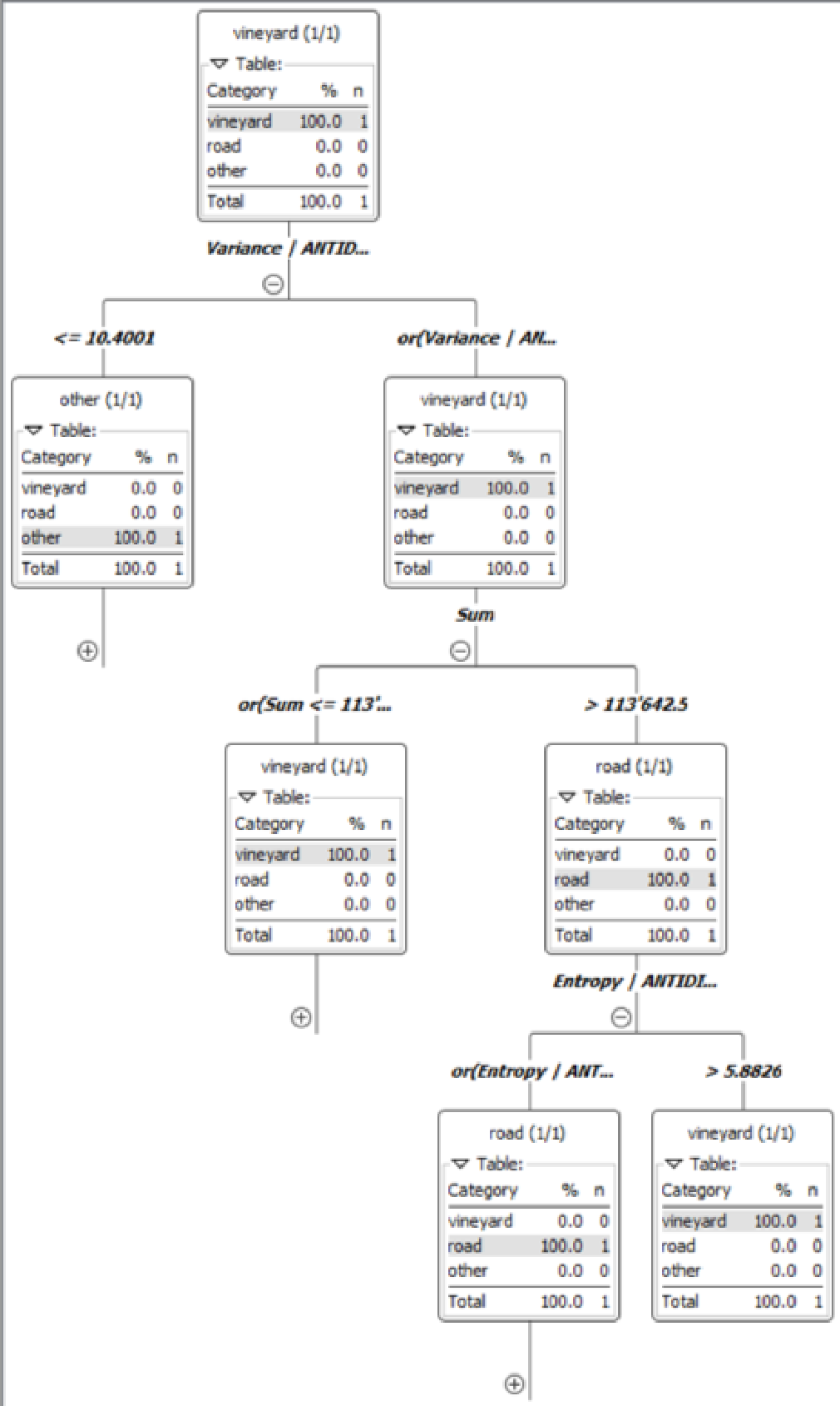 Figure 1: The DTE structure reveals that 'Variance / Antidiagonal' is a primary separator, proving that spatial variance is more tell-tale than mere color.
Experiments & Results
The researchers compared their DTE model against a baseline rooted in the Hough Transform and intensity histograms (the current industry standard).
| Method | Accuracy | Standard Error |
|---|---|---|
| Baseline (Intensity Analysis) | 89.6% | ±1.01% |
| DTE (Proposed Methodology) | 94.27% | ±1.14% |
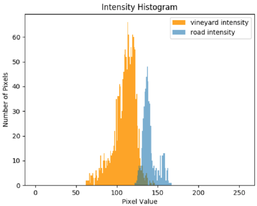 Figure 2: Optimal tile sizing (30x33px vs 78x80px). The smaller tiles (left) ensure each segment contains primarily one class, leading to higher classification purity.
The results show that while the baseline is "stable," it consistently misclassifies roads as vineyards when their color intensities overlap. The DTE model ignores this intensity trap by identifying the distinct directional texture of vine rows.
Critical Analysis & Conclusion
Takeaway: This research successfully proves that for high-precision UAV applications, the "texture" of the land is just as important as its "color." By utilizing a Decision Tree Ensemble, the system becomes robust enough to handle the visual noise of real-world farming.
Limitations: The authors honestly note that this model expects aligned vineyards. In regions like Northern Italy, where vines are grown over non-linear wood constructions, the current spatial features might fail.
Future Outlook: The next logical step is moving toward Deep Learning (CNNs or SegNet), which could potentially learn these spatial features automatically without the need for manual Tamura or Haralick extraction. However, the DTE approach remains highly valuable for edge computing where UAVs have limited battery and processing power.