
Beyond Clusters: Leveraging Multilevel Optimization for Precise LBSN Construction
Local-entity resolution for building location-based social networks by using stay points
The paper introduces a novel approach for local-entity resolution to build Location-Based Social Networks (LBSNs) using GPS stay points. It utilizes the coarsening phase of a multilevel optimization scheme to group stay points based on both geographic proximity and trajectory topology, outperforming traditional clustering methods in mapping physical venues.
TL;DR
Building Location-Based Social Networks (LBSNs) from raw GPS logs is notoriously difficult due to "local-entity resolution"—the task of grouping GPS stay points into unique physical venues. This paper moves beyond traditional geographic clustering by introducing a multilevel optimization approach. By treating stay points as nodes in a graph and utilizing user trajectory topology (sequence of visits), the proposed NGNnSM algorithm achieves an ARI of over 93%, successfully distinguishing between nearby venues where traditional methods fail.
The "Close-Proximity" Trap
In the world of LBSNs, a "stay point" represents a location where a user spent significant time. The standard pipeline to identify a venue (like a specific cafe) is to cluster these stay points. However, if a cafe and a bookstore are in the same building or side-by-side, density-based algorithms like OPTICS often merge them into a single "super-vertex."
The authors identify a critical oversight: movement logic. If a user visits two points sequentially on the same day, they are almost certainly distinct venues, regardless of how close they are geographically. Traditional clustering ignores this temporal and sequential context.
Methodology: The Multilevel Graph Approach
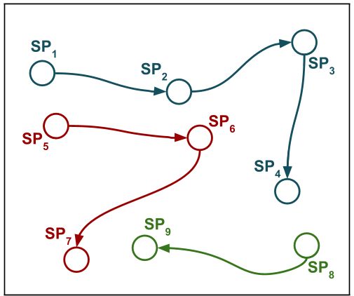
The core innovation lies in viewing stay points not as isolated dots on a map, but as vertices () in a network ().
1. The Initial Network
The authors build an initial graph using two types of edges:
- Proximity-edges: Connect a vertex to its nearest neighbors based on distance.
- Sequence-edges: Connect vertices visited sequentially by a user.
2. Matching and Contraction
Instead of clustering in one shot, the authors use a coarsening phase (a technique borrowed from multilevel optimization). They propose two matching algorithms:
- NGNM (Nearest Geographical Neighbor Matching): Matches based on the closest spatial neighbor within a threshold.
- NGNnSM (Nearest Geographical Neighbor non-Sequential Matching): The star of the paper. It matches the closest neighbor only if they were not visited sequentially. This constraint preserves the identity of distinct nearby venues.
Matched vertices are then contracted into "super-vertices," and the process repeats until the network stabilizes.
Quantitative Battle: NGNnSM vs. The World
The researchers tested their method against common baselines like OPTICS, Complete-linkage (CL), and Average-linkage (UPGMA) using datasets from Gowalla and Brightkite.
Key Findings:
- Consistency: Traditional methods (OPTICS) see a sharp performance drop as the distance threshold increases (losing "Homogeneity"). The proposed multilevel algorithms remain stable.
- Accuracy: In the Gowalla dataset, where trajectories are more extensive, NGNnSM significantly outperformed check-in based clustering because it effectively utilized the abundant trajectory sequences.
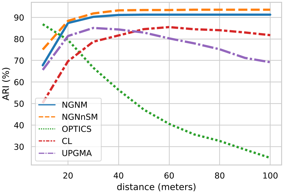 Average ARI comparison across different distances.
Statistical Superiority
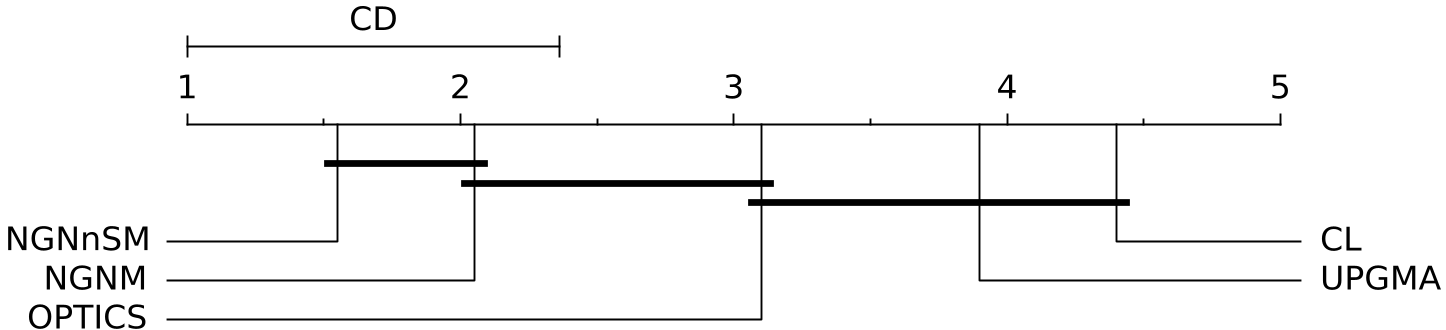
The Nemenyi post-hoc test confirms that NGNnSM is statistically superior to the baseline clustering methods, ranking first overall.
Critical Insight: Why it Works
The "coarsening" strategy essentially acts as a iterative filter. In each step, the model identifies the most certain matches first. By incorporating the non-sequential constraint, the algorithm uses the physics of human movement—the fact that we cannot be in two distinct places at the exact same moment—to solve a purely spatial ambiguity.
Limitations & Future Path
While highly effective, the algorithm never achieves perfect completeness. This is likely because GPS noise can sometimes be too large for even topological constraints to overcome. The authors suggest that the next frontier is Semantic-Aware Resolution: using the category of the venue (e.g., "Park" vs. "Hospital") to further refine the matching process within the multilevel framework.
Conclusion
This paper provides a robust solution for a foundational problem in trajectory mining. By shifting from "points in space" to "nodes in a trajectory network," the authors have created a tool that is more resilient to the noise and density of modern urban environments.