
LBSN: Transforming Campus Maps into Social Ecosystems
Location-based social networking information services in university campus
The paper introduces a Location-Based Social Networking (LBSN) information system specifically tailored for university campuses. It integrates 3D digital mapping with social networking features, enabling students and faculty to share location-specific comments, recommendations, and reviews to enhance campus navigation and community engagement.
TL;DR
Researchers from Tsinghua University developed a Location-Based Social Networking (LBSN) system that moves away from static digital maps toward a dynamic, user-contributed ecosystem. By merging 3D visualization with social features like "liking" and "commenting" on specific buildings, the system transforms the campus from a set of coordinates into a vibrant information hub for students and faculty.
Background & Motivation: Beyond the Static Map
In the traditional "E-campus" model, information is top-down. The university provides a map, a directory, and perhaps an E-card system. However, these systems often feel disconnected and "cold." For a freshman, knowing a building is "Building M" is less useful than knowing it houses the best coffee on campus or has specific quiet hours.
The authors identified that while Location-Based Services (LBS) and Social Networking Services (SNS) are mature, their intersection in a hyperlocal environment like a university was largely unexplored. They aimed to solve the "isolation" of the traditional user—who only pulls data—by allowing them to push value back into the system.
Methodology: The Four Pillars of Campus Connectivity
The system is built on four core modules designed to facilitate a "proactive" user experience:
- 3D Campus Map System: Unlike 2D maps, this utilizes 3D geographic information for higher lifelike accuracy. Crucially, the authors added "nicknames" and real-world photos to bridge the gap between official records and student reality.
- Information Navigation: A 16-category hierarchy (Food, Store, Gym, etc.) that uses a dynamic reordering algorithm. Categories most frequently accessed by the community rise to the top.
- Location Information Management: This is the SNS "kernel." It allows for collaborative tagging and social feedback (Like/Dislike/Important buttons) directly on the location's detail page.
- User Information Management: A secure, verified system using university emails to ensure a polite and accountable social environment.
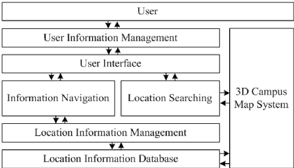 Figure: The structural framework of the LBSN system shows the interplay between the map, categories, and user-generated content.
The Shift in User Patterns
The most striking part of the research is the comparison between traditional and social usage patterns. In a traditional system, the user is an island. In the LBSN model, physical locations (like a specific building 'M') become digital meeting rooms where seniors (O1, O2) can guide freshmen (T1) through asynchronous comments and reviews.
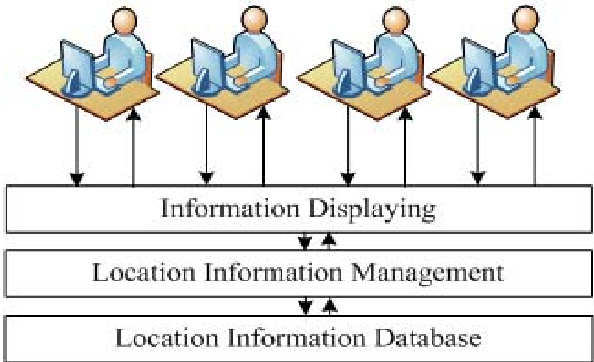 Figure: Traditional "isolated" data retrieval (Left) vs. the "collaborative" LBSN pattern (Right).
Experimental Validation & Impact
Deployed at Tsinghua University, the system has been operational for over a year.
- Data Enrichment: Added 200+ nuanced location points that official maps missed.
- Engagement: Hundreds of active users (students/teachers) transitioned from being passive consumers to active contributors.
- Optimization: The dynamic category reordering ensured that seasonal or high-traffic needs (like "Express" delivery during shopping festivals) were met efficiently.
Critical Insight & Future Outlook
The paper's core achievement is proving that location is a social catalyst. By making the map "social-aware," the system reduces the information asymmetry for newcomers.
Limitations: The current system relies on a web-based portal. In 2024 and beyond, the logical evolution would be a mobile-first, AR-integrated application that provides real-time "heads-up" social data as a user walks through campus.
Future Work: The authors envision adding Real-Time Logistics (campus bus tracking) and Event Appointments, effectively turning the map into a real-time Operating System for campus life.