
Location-Based Social Simulation: Solving the Data Crisis in Geo-Social Research
Location-Based Social Simulation
The paper proposes a vision for a large-scale geo-simulation framework designed to generate synthetic yet realistic Location-Based Social Network (LBSN) data. By employing Agent-Based Modeling (ABM), the framework aims to produce massive, high-fidelity datasets that capture user locations and social interactions over multiple years to overcome current research bottlenecks.
TL;DR
LBSN research is currently hitting a wall due to sparse, noisy, and privacy-restricted datasets. This paper outlines a vision for a massive geo-simulation framework that uses Agent-Based Modeling (ABM) to create synthetic yet socially plausible human mobility data. By simulating millions of agents over years, researchers can finally work with "perfect" ground-truth data to benchmark recommendation systems and privacy algorithms.
The Data Scarcity Paradox
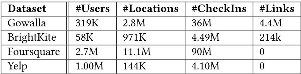
In the era of Big Data, Location-Based Social Network (LBSN) research ironically suffers from a profound lack of quality data. While platforms like Foursquare and Yelp collect billions of data points, the datasets available to the academic community are:
- Structurally Sparse: Most users have fewer than 10 check-ins, leading to a "long-tail" distribution that makes training deep models nearly impossible.
- Privacy-Tainted: Even anonymized data can be re-identified, and users frequently revoke consent by deleting accounts—a change not reflected in static research datasets.
- Deceptive: There is no "ground truth." If two people check into the same bar, are they best friends or total strangers? Without knowing the true intent, our friend-recommendation algorithms are just guessing.
The Methodology: Simulating Human Intent
The authors argue that if we cannot get perfect real-world data, we should build a world that is "good enough" to be realistic but "perfect" in its visibility. Their approach rests on two pillars:
1. Psychological Plausibility
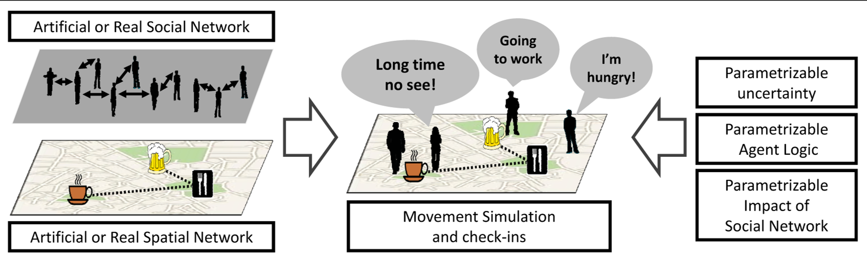
Instead of moving agents randomly (like traditional data generators), they integrate Maslow’s Hierarchy of Needs and the Theory of Planned Behavior. Agents move because they have:
- Physiological Needs: Seeking food at specific intervals.
- Social Needs: Meeting friends at "recreational locations" based on their specific social network.
- Patterns of Life: Following a home-work-social routine that mirrors human rhythms.
2. High-Fidelity Infrastructure
Using GeoMASON, an extension of the MASON simulation toolkit, the framework simulates the interaction between three distinct networks:
- User-User: The social link ground truth.
- Location-Location: The spatial proximity and semantic similarity (e.g., "coffee shop" vs. "office").
- User-Location: The bipartite graph of actual check-in events.
Why This Matters for the Future of AI
The implications of "Omniscient Data" are vast:
- Social Link Discovery: For the first time, researchers can assess if an algorithm is predicting a real friendship or just a coincidental co-location.
- Location Recommendation: We can verify if a recommender system is truly generalizable across a population or just overfitting to a small group of "super-users."
- Privacy Stress-Testing: Using synthetic high-fidelity trajectories, we can test just how easy it is for an adversary to de-identify a user, without actually endangering real people.
Critical Analysis & Looking Ahead
While the vision is ambitious, the primary challenge remains calibration. A simulation is only as useful as its alignment with real-world statistics. If the agents' behavior is too "logical" or "ordered," models trained on them might fail when faced with the chaotic, irrational nature of real human movement.
The framework proposes using Google BigTable for storage and parallelization, highlighting the sheer scale required. As we move toward 2026, the convergence of LLM-driven agent behavior and these geo-spatial frameworks could lead to "Digital Twins" of entire cities, providing a sandbox for everything from urban planning to epidemic modeling.
Takeaway
By shifting from data collection to data simulation, we bypass the ethical and technical hurdles of real-world LBSN data, paving the way for more robust and scalable spatial AI.