
Geo-Informatics Models: Bridging Monitoring and Policy in Regional Ecological Security
Research on Monitoring, Evaluation and Adjustment Models about Regional Ecological Security
This paper presents a comprehensive framework for regional ecological security by integrating Remote Sensing (RS) monitoring, GIS-based evaluation, and System Dynamics (SD) adjustment models. Applied to the Xishuangbanna region, the study demonstrates a multi-stage methodology to identify, assess, and simulate ecological-economic trade-offs.
TL;DR
This research establishes a rigorous technical pipeline for ecological security, moving from Remote Sensing (RS) for real-time monitoring to GIS for spatial evaluation, and finally System Dynamics (SD) for long-term policy simulation. Using Xishuangbanna as a testbed, the study identifies a "Harmonious" development path as the most sustainable trajectory for regional survival.
Background: Beyond Static Conservation
Ecological security is no longer just about "protection"; it is a multi-dimensional state where human health, social order, and resources are resilient to environmental change. Historically, researchers have struggled to link the physical observation of land changes with the socio-economic drivers that cause them. This paper argues that geo-informatics models serve as the "analytical replacers" of reality, allowing us to test intervention strategies before they are implemented.
The Methodology: The Three-Stage Triad
1. RS-Based Factor Monitoring
The first step involves decomposing the environment into monitorable features. The authors focus on two critical indicators:
- Vegetation Coverage (): Utilizing the Normalized Difference Vegetation Index (NDVI), the model estimates the ratio of plant crown area to total land area.
- Soil Erosion Model: A weighted combination of vegetation coverage, slope gradient, and soil type to determine environmental degradation levels.
2. GIS-Based Comprehensive Evaluation
To move from raw factors to an "Ecological Security Index" (ESI), the study employs weighted layer analysis on raster units. This transition allows researchers to visualize security levels across different administrative or drainage basins.
3. SD-Based Adjustment (The "Secret Sauce")
The core innovation lies in the System Dynamics (SD) model. Unlike static maps, SD models simulate the flow of energy, population, and information.
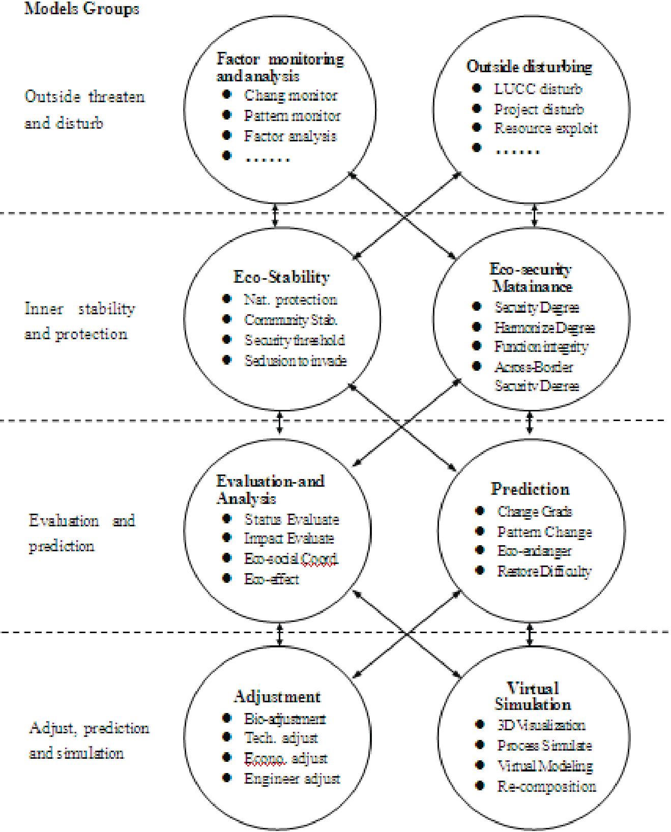 Fig. 1: The Integrated Model System of Regional Ecological Security.
Simulation Results: The Case of Xishuangbanna
The researchers modeled the ecological-economic system of Xishuangbanna with a 25-year horizon (starting from 2000). They tested three distinct "Modes":
- Economic Mode: Focuses on GDP and efficiency. Result: Rapid growth but excessive pressure on the environment.
- Harmonious Mode: Balances ecological needs with moderated economic speed. Result: Selected as the optimal path.
- Ecologic Mode: Pure protection. Result: Over-emphasizes nature at the cost of social development.
The model utilizes the status equation: where represents status variables like population and GDP growth rates.
Critical Insight & Future Outlook
The paper highlights a critical philosophical shift in environmental science: is it possible to adjust the system level? While we can easily monitor "gases and water," adjusting the "energetic transition" of a whole region is vastly more complex.
Limitations
- Linear Simplification: The vegetation model assumes a linear relationship between NDVI and coverage, which may not hold in extremely dense tropical canopies.
- Weight Subjectivity: GIS-based ESI relies on weights () that are often determined by expert opinion, introducing potential bias.
Final Takeaway
This work provides a foundational "Geo-Informatics" blueprint. By coupling the spatial precision of GIS with the temporal foresight of System Dynamics, it transforms ecological security from a vague concept into a quantifiable, manageable engineering challenge.