
AttMTL-M: Revolutionizing Road Attribute Updating with Multi-Task Learning and Map Imagery
A Multi-task Learning Framework for Road Attribute Updating via Joint Analysis of Map Data and GPS Traces
The paper introduces AttMTL-M, a multi-task learning framework designed to automatically update road attributes (one-way/two-way status, lane counts, and speed limits). By jointly analyzing GPS traces (bearing, speed, and location) and visual map tile features via an attention-based fusion mechanism, it achieves SOTA performance on OpenStreetMap data.
TL;DR
Maintaining digital maps is traditionally a manual, labor-intensive process. Researchers from the National University of Singapore and Grab have introduced AttMTL-M, a deep learning framework that automatically predicts road attributes (one-way/two-way, lanes, and speed limits). By fusing GPS sensor data with visual "map tiles" using a multi-task attention mechanism, they have surpassed previous state-of-the-art methods by up to 15.6% in speed limit accuracy.
The Gap in Current Map Inference
While GPS trajectories have been used for years to infer road geometry (the "where" of the road), determining road attributes (the "how" of the road) remains difficult. Current SOTA suffers from two main flaws:
- Task Isolation: Existing models predict speed limits and lane counts separately, ignoring the fact that these features are physically and logically correlated.
- Visual Neglect: Most methods rely solely on sparse GPS points, ignoring the rich contextual "visual" data already present in digital maps (like the presence of buildings, road thickness, and surrounding topology).
The Core Concept: Joint Analysis and Attention
The authors' breakthrough lies in treating the map update problem as a Multi-Modal Multi-Task Learning problem.
1. Multi-Modal Feature Extraction
The system extracts four distinct types of features:
- Location Encoding: Histogram of distances to the road center (hints at lane count).
- Bearing Encoding: Alignment of vehicle direction (determines one-way/two-way).
- Speed Encoding: Histogram of velocities (determines speed limits).
- Visual Map Tiles: 3-channel RGB images cropped at road centers (captures geographic context).
2. Architecture: Shared Embeddings and Task-Specific Attention
Instead of just concatenating these features, AttMTL-M uses a shared embedding layer to learn universal road representations. However, because "bearing" matters more for one-way detection than for speed limits, they introduced an Attention-Based Feature Fusion layer.
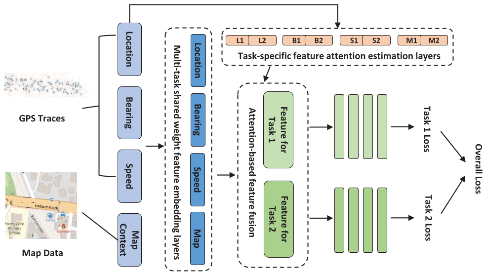 Figure 1: Overview of the AttMTL-M framework showing the flow from raw GPS/Map data to task-specific fused representations.
The attention module generates scores () that weigh each feature type differently for each specific task, allowing the model to focus on the most relevant data for each attribute being predicted.
Experimental Results: A Performance Leap
The framework was tested on OpenStreetMap (OSM) data in Singapore. The results were striking when compared to traditional Decision Trees (DecTree) and simple concatenation models (ConFus).
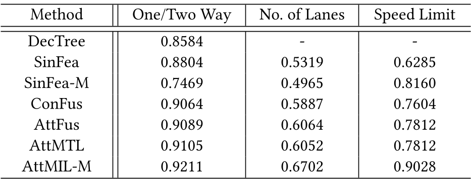 Figure 2: Performance comparison across different attributes. AttMTL-M consistently outperforms all baselines.
Key Gains:
- Speed Limit Detection: Jumped from 78.1% (AttMTL) to 90.2% (AttMTL-M) by adding visual map features.
- Lane Detection: Accuracy Improved by over 10% across various urban test areas.
- Robustness: The model's "± One Class" accuracy was exceptionally high, meaning even when the model misses the exact count (e.g., 3 lanes), it usually predicts the neighboring value (e.g., 2 or 4 lanes), making it highly usable for practical routing.
Critical Analysis & Conclusion
Why this matters
The inclusion of Map Tiles as a visual feature is a game-changer. It leverages the existing work of human cartographers (who designed map visualization rules) as a high-level feature for machine learning. By using a CNN to "look" at the road center, the model gains a human-like intuition about whether a road is a major highway or a narrow alley.
Limitations & Future Work
While highly effective, the current model uses 3-channel RGB images. The authors suggest that moving to multi-channel tensors (e.g., separate channels for buildings, rivers, and road types) could further reduce information loss. Additionally, the reliance on pre-matched GPS traces (via HMM) means the model is only as good as the map-matching algorithm—a potential bottleneck in highly dense urban canyons.
In summary, AttMTL-M proves that the path to smarter maps isn't just more data, but better fusion of the diverse data we already have.