
LBSN Recommender Systems: Navigating the 3D Landscape of User, Location, and Activity
14285_Objectives and State-of-the-Art of Location-Based Social Network Recommender Systems.
This paper provides a comprehensive survey of Location-Based Social Network (LBSN) recommender systems, categorizing them based on a 3D relationship model among users, locations, and activities. It defines eleven distinct recommendation objectives and reviews state-of-the-art algorithms, including those utilizing Collaborative Filtering (CF), Tensor Factorization, and HITS-based inference.
TL;DR
Recommender systems have evolved beyond suggesting movies on Netflix. This comprehensive survey explores Location-Based Social Networks (LBSNs), where recommendation is a multidimensional puzzle involving Who (Users), Where (Locations), and What (Activities). By leveraging GPS trajectories and social ties, these systems can predict the next best place for you to visit or the best activity to perform in a new city.
Contextualizing the Problem: Beyond 2D Matrices
Traditional recommenders operate on a 2D plane: User Item. However, humans don't exist in a vacuum. In the physical world, our choices are constrained by geography and time.
The transition to LBSNs introduces three fundamental challenges:
- Spatial Constraints: Unlike digital items, physical locations have "costs" (travel distance).
- Data Sparsity: The "User-Location" matrix is exponentially sparser than a "User-Movie" matrix. You might watch 1,000 movies, but you probably only visit a few dozen unique venues regularly.
- The Cold Start Trap: When you visit a new city like Shanghai for the first time, the system has zero history for you in that "Cell."
Methodology: The 3D Object Framework
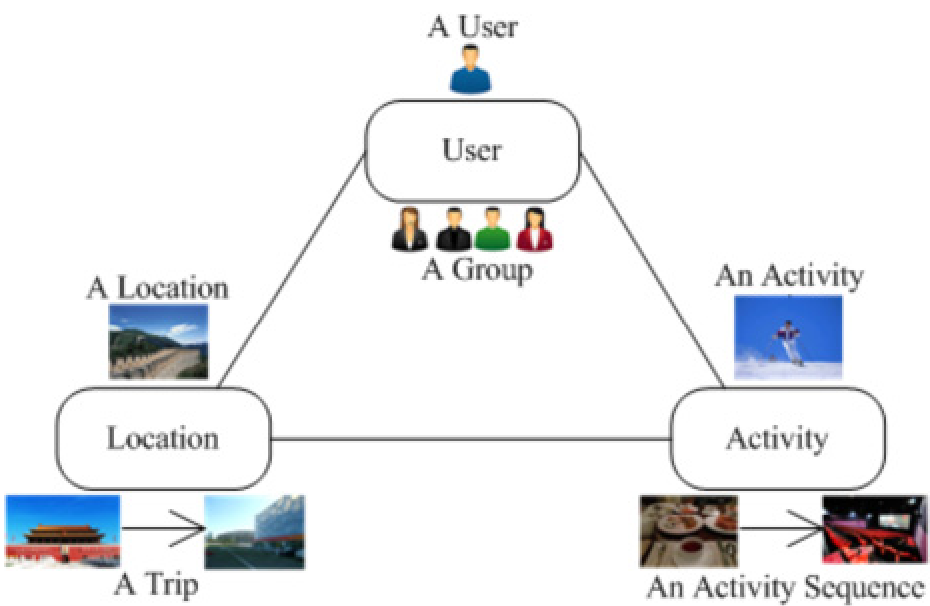
The paper redefines the recommendation space into a trivalent relationship. To handle the complexity, researchers decompose these into six sub-objects:
1. Mining Global Significance (HITS & TBHG)
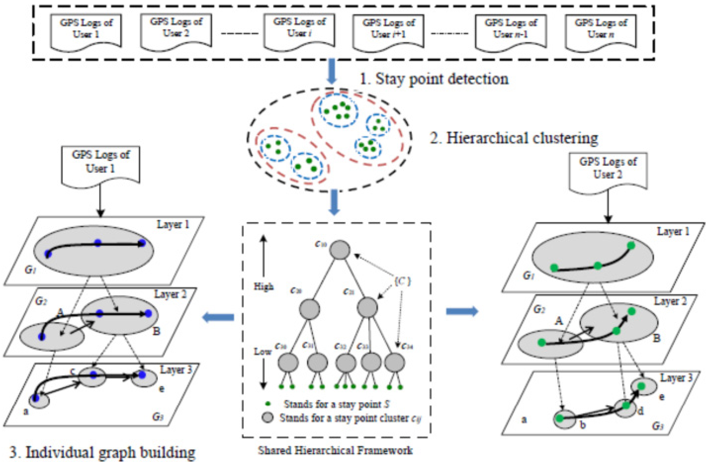
How do we know a place is "popular"? It’s not just about raw check-in counts. The authors discuss the Tree-Based Hierarchical Graph (TBHG), which models locations at different scales (from buildings to districts). Using the HITS (Hyperlink-Induced Topic Search) algorithm, the system identifies "Hub" users (expert travelers) and "Authority" locations (significant landmarks).
2. Personalization through Tensors
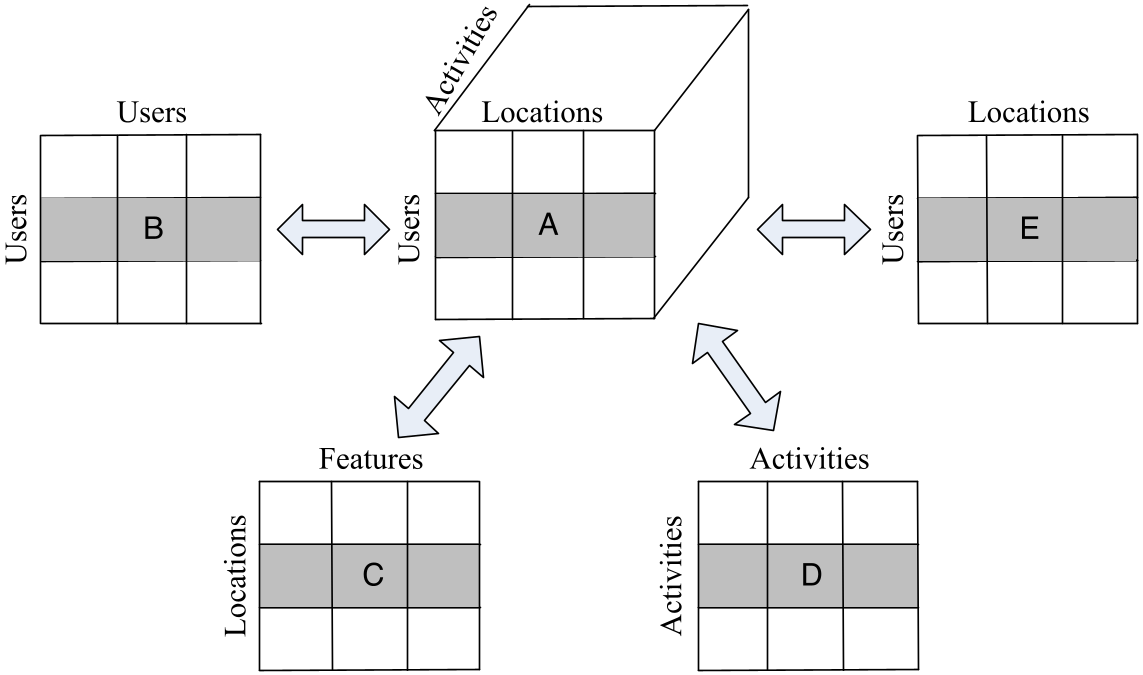
To solve the "who-where-what" problem, many SOTA methods use Tensor Factorization. Instead of a flat matrix, they build a 3D cube. When data is missing, they apply High-Order Singular Value Decomposition (HOSVD) to "fill in the blanks," effectively predicting what activity a user would enjoy at a specific latitude/longitude.
Critical Insight: Why Does Geometry Matter?
One of the most profound takeaways is the Inductive Bias of geography. The "Tobler’s First Law of Geography"—everything is related to everything else, but near things are more related than distant things—is encoded into these models via the Power Law Distribution of travel distance. By weighting recommendations based on distance , models become significantly more accurate at predicting daily routines.
Experiments & Core Results
The paper synthesizes results from massive datasets (Foursquare, Gowalla, and Flickr).
- Temporal Impact: Methods like LRT (Location Recommendation with Temporal effects) prove that check-in patterns are periodic. Recommending a gym at 8 AM is "correct," but recommending it at 11 PM is a "failure," even if the user loves the gym.
- Social Correlation: The "Geosocial" correlation suggests that your friends' movement patterns are the strongest predictors of your future locations, especially when your own history is sparse.
The Future: Group Dynamics and Activity Sequences
While we are good at recommending a single "Point of Interest" (POI), we are still in the early stages of:
- Group Recommendations: Recommending a 3-day itinerary for a family of four with different interests.
- Activity Sequences: Predicting the logic of "Lunch Movie Dinner" rather than suggesting three random activities.
Final Takeaway
This paper serves as a roadmap for anyone building spatial intelligence. It moves the conversation from "what does this user like?" to "where is this user, what time is it, and what are they capable of doing right now?"
As we move toward Smart Cities, these LBSN frameworks will become the invisible backbone of urban navigation and localized commerce.