
Beyond Check-ins: Mining Geographic Trajectories for Smarter Friend Recommendations
Online Friends Recommendation Based on Geographic Trajectories and Social Relations
This paper introduces a novel online friend recommendation method that integrates geographic trajectories with social network structures. By representing user movement as time-ordered sequences, the authors propose a trajectory reduction and normalization technique combined with a hybrid similarity measure focusing on both spatial distance and movement trends.
TL;DR
This research moves beyond simple location-sharing by analyzing the chronological sequence of user movements. By combining the physical distance between users with the "trend" (shape) of their trajectories, the authors developed a recommendation engine that understands not just where you are, but how you move through the world.
The "Habit" Gap in Social Networking
Why do we become friends with some people and not others? In the physical world, "propinquity" (physical proximity) is a major driver. However, traditional online recommendation systems are often "location-blind" or treat location as a static attribute (e.g., "Users who both visited Central Park").
The fatal flaw in existing geographic models is the loss of temporal context. If User A goes from Home Work Gym, and User B goes Gym Work Home, their interests and daily rhythms are fundamentally different, even if their "location sets" are identical. This paper argues that the order of positions reflects personal habits that are key to meaningful social connections.
Methodology: Distance meets Direction
The proposed framework operates in three distinct phases:
1. Trajectory Reduction & Normalization
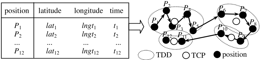
Raw GPS data is noisy and voluminous. The authors use a clustering approach to identify Trajectory Center Points (TCPs). Crucially, they introduce an iterative normalization process to ensure that different users—ranging from "active travelers" to "otakus" (homebodies)—can be compared across a fixed-length sequence using an adaptive threshold .
2. The Hybrid Similarity Metric
The core innovation lies in the formula, which balances two insights:
- Distance Similarity (): Uses trigonometric transformations to calculate the great-circle distance between corresponding points in two sequences.
- Trend Similarity (): Converts the movement between points into slope vectors (). This captures whether two users are moving in the same "shape" or direction over time.
The final score is a weighted sum:
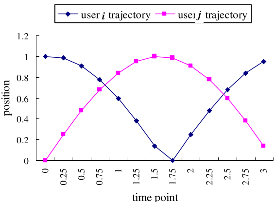 Figure (a) shows users with identical trends but far distances; (b) shows close distance but opposite trends. Only a combined metric captures the true similarity.
Experimental Results
The authors validated their approach using data from Sina Weibo and location-service communities.
- Accuracy: Compared to a standard DBSCAN clustering method, this trajectory-aware approach achieved an 85.9% accuracy in predicting user similarity.
- Optimal Weighting: Through an online voting activity where users picked potential friends, the researchers found that provided the best results. This indicates that while physical distance is the dominant factor (roughly 60% weight), the "shape" of the journey contributes a significant 40% to the recommendation's perceived value.
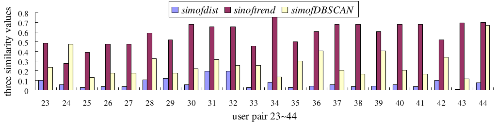 Experimental comparison showing the proposed similarity metrics vs. baseline DBSCAN results.
Critical Insight & Future Outlook
The beauty of this work lies in its simplicity. By using slopes and normalized TCPs, the authors circumvent the heavy computational cost of complex sequence alignment algorithms like Dynamic Time Warping (DTW) while still preserving temporal logic.
Limitations: The current model assumes users have a similar number of check-ins or data points after normalization, which may lead to "truncation errors" for extremely nomadic users. Additionally, the social graph is currently used as a secondary filter; a deeper "Graph Neural Network" (GNN) integration could likely push accuracy even higher.
Takeaway: For developers building LBS (Location Based Services), the message is clear: stop looking at where your users are and start looking at how they get there.