
OSCS: Bridging the Expertise Gap in Spatial Clustering through Ontology
An Ontology-Based Spatial Clustering Selection System
This paper introduces the Ontology-based Spatial Clustering Selection system (OSCS), a framework designed to bridge the gap between complex spatial data mining algorithms and non-expert users. By formalizing spatial clustering knowledge into an OWL-based ontology and utilizing a Pellet reasoner, the system automates the selection of optimal algorithms based on user-defined constraints and data characteristics.
TL;DR
Selecting the "right" spatial clustering algorithm is often a black art reserved for GIS experts. The Ontology-based Spatial Clustering Selection (OSCS) system democratizes this process. By encoding spatial mining knowledge into a formal ontology and using an automated reasoner, OSCS allows users to describe their goals in high-level terms (e.g., "handle noise," "specific constraints") and automatically receive the most efficient algorithm recommendation.
Background & Positioning
In the landscape of spatial data mining, we have moved from a scarcity of algorithms to an overwhelming abundance. While methods like K-Means, DBSCAN, or CLARANS are powerful, their effectiveness is highly context-dependent. OSCS positions itself as a Knowledge Representation & Reasoning layer that sits between the user and the library of algorithms, serving as a "Semantic Consultant."
The Core Challenge: Semantic Complexity
Why is picking an algorithm hard?
- Multiple Taxonomies: Is an algorithm partition-based, density-based, or grid-based? Often, they are hybrid.
- Implicit Constraints: Some algorithms fail on large datasets; others are sensitive to outliers. Non-experts often ignore these "Inductive Biases," leading to suboptimal or misleading clusters.
- Lack of Formalism: Prior works lacked a rigorous "Task Model" to decompose a user's goal into a specific computational execution.
Methodology: The OSCS Architecture
The backbone of the system is the Spatial Clustering Ontology written in OWL.
1. The Ontology Structure
The researchers didn't just list algorithms. They created a two-dimensional mapping:
- Hierarchical Category: Rooted in technical lineages (e.g., Hierarchical vs. Partitional).
- Characteristic Mapping: Defining algorithms by their "DNA"—Attributes type, Dimensionality support, Noise influence, and Distance measures.
2. The Reasoner (The "Brain")
Using the Pellet Reasoner, the system performs "Problem Solving Methods" (PSM). It takes the user's requirements (e.g., "large dataset with noise") and traverses the ontology to find the individual algorithm (Elementary Task) that satisfies all semantic axioms.
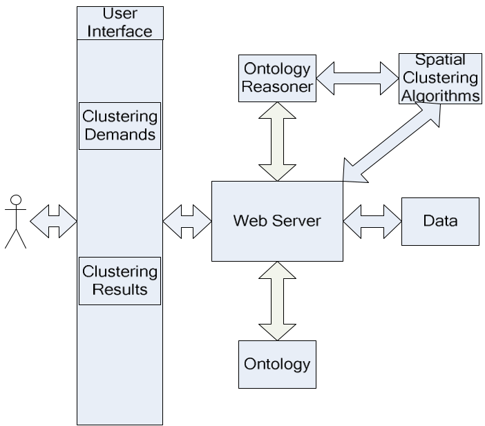 Figure 1: The OSCS architecture showing the flow from User Interface to the Ontology Reasoner.
Experiments: Real-world Optimization
The authors tested OSCS on a Facility Location Problem in South Carolina (Census 2000 data). The task: determine the best spots for five hospitals.
Standard practice might suggest a simple K-Means. However, the OSCS system, considering the spatial constraints and capacity requirements, recommended Capability K-MEANS.
Key Results
The "Expert System" recommendation wasn't just theoretically better; it yielded tangible geographical efficiency:
| Metric | Capability K-MEANS (Recommended) | Standard K-MEANS |
|---|---|---|
| Avg. Traveling Distance | 59.7 km | 61.3 km |
| Max. Traveling Distance | 322 km | 328 km |
 Figure 2: Performance comparison verifying that the ontology-selected algorithm outperforms the "default" choice.
Critical Analysis & Takeaways
The brilliance of OSCS lies in its Semantic Abstraction. By moving the decision-making from "which code do I run" to "what are my data's properties," it reduces the barrier to entry for spatial analysis.
Limitations:
- Ontology Maintenance: As new algorithms emerge (like Graph Neural Network-based clustering), the ontology must be manually updated by experts.
- Performance Scale: The paper focuses on a dataset of 867 tracts; how the reasoner handles thousands of conflicting constraints in real-time remains a question for future "Big Data" iterations.
Conclusion: The OSCS system proves that domain knowledge, when formalized, is just as important as the algorithms themselves. Success in spatial mining isn't just about having the fastest algorithm—it's about having the right one for the specific geometry of the problem.