
Smart Incentives for Better Maps: Pricing Mechanism for Quality-Based Radio Mapping
Pricing Mechanism for Quality-Based Radio Mapping via Crowdsourcing
This paper introduces a quality-based pricing mechanism for crowdsourced Radio Environment Maps (REMs) by modeling hardware noise within a Gaussian Process (GP) framework. The authors propose a sequential "take-it-or-leave-it" offering strategy that maximizes the platform's expected utility based on noise-aware Mutual Information (MI), achieving superior performance over greedy and random-offer baselines.
TL;DR
The shift towards White Space (WS) networking requires accurate Radio Environment Maps (REMs). This paper presents a novel pricing strategy for crowdsourcing these maps. By explicitly modeling hardware noise in a Gaussian Process and using a sequential Expected Utility maximization algorithm, the authors provide a way to recruit the right users at the right price, even when their sensing costs are private and their devices are inconsistent.
Problem & Motivation: The Chaos of Crowdsourcing
Building a map of radio signal strength across a city is a massive logistical challenge. You could deploy thousands of fixed sensors (expensive) or ask thousands of people with smartphones to do it for you (cheap but messy).
In the "messy" crowdsourcing world, two factors break traditional models:
- Heterogeneity: A high-end tablet has a better antenna and lower noise than a budget smartphone.
- Private Costs: Users won't tell you exactly how much money they want; they just accept or reject your offer based on their current battery level and inconvenience.
Previous works often treated all data points as equally valid. This paper argues that if you don't account for the "noise" each device brings, your resulting map will be fundamentally flawed.
Methodology: Noise-Aware Perception
The core innovation lies in modifying the standard Gaussian Process (GP) used for spatial interpolation to include a device-specific noise term.
1. The Noise-Aware RSSI Model
The authors model the Received Signal Strength Indicator (RSSI) as: Where is the hardware noise. By incorporating this into the covariance matrix , the platform can calculate Mutual Information (MI)—a metric that tells us how much "uncertainty" about the whole region is reduced by hiring a specific user.
2. Sequential Pricing Algorithm
The platform doesn't just broadcast a price. It calculates an Optimal Offer () for each user sequentially.
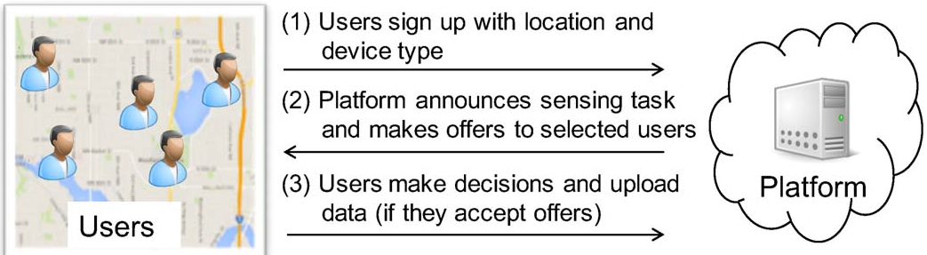 Fig 1: The architecture of the crowdsourcing platform and its interaction with users.
The platform's utility is the value of the information gained minus the price paid. Since the user might reject the offer, the platform maximizes Expected Utility (EU):
Experiments & Results
The authors simulated a 25-location region with varying user densities and noise levels.
Performance vs. Baselines
The proposed mechanism was compared against a greedy utility maximizer and a random pricer.
- Generous Start: The algorithm is "generous" with early prices (high ) to ensure the first few, most valuable "anchors" for the map are secured.
- Efficiency: As more data is gathered, it becomes more "stingy," only paying for high-quality, low-cost data that fills crucial gaps.
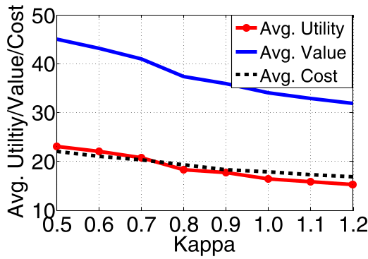 Fig 2: The proposed mechanism consistently achieves higher utility by smartly balancing the probability of rejection against technical gain.
The Impact of Noise
One of the most striking findings is how much hardware noise degrades value. Even a small increase in noise can slash the Mutual Information (sampling value) by half, proving that knowing the "Device Type" is just as important as knowing the "User Location."
Critical Analysis & Conclusion
Takeaway
This work bridges the gap between geostatistical modeling and microeconomics. It proves that the "value" of a data point is not just its information content, but its information content adjusted for the reliability of the source hardware.
Limitations
- Honesty Assumption: The model assumes users are honest about their locations and device types. In a real-world deployment, "Sybil attacks" or spoofed data could easily bypass this mechanism.
- Mobility: The paper assumes low mobility. In a fast-moving city, the spatial value of a user changes rapidly, requiring even faster computation than the complexity proposed.
Future Outlook
This framework could be extended to multi-modal sensing (e.g., combining radio data with air quality) where different sensors have different noise profiles but share the same spatial correlations.