
eBayanihan Patroller: Bridging the Digital Divide in Disaster Response via SMS and Geotagging
Rapid Application Development of Ebayanihan Patroller: A Crowdsourcing SMS Service and Web Visualization Disaster Reporting System
The paper introduces eBayanihan Patroller, a rapid-response disaster reporting system designed for the Philippines. It combines a crowdsourcing SMS service with an automated Geotagging and Web Visualization platform to facilitate real-time communal situational awareness during natural disasters.
TL;DR
The Philippines, facing an average of 19 typhoons yearly, requires immediate information flow to save lives. eBayanihan Patroller is a specialized disaster-reporting system that leverages the high penetration of SMS in the Philippines to crowdsource situation reports, automatically geotags them, and visualizes them on a web dashboard for authorities.
Positioning: This work represents a practical, "boots-on-the-ground" implementation of Community-Based Disaster Risk Management (CBDRM), shifting from manual SMS monitoring to automated spatial visualization.
Problem: The SMS Bottleneck in Crisis Management
During disasters like Tropical Storm Washi (Sendong), local government units (LGUs) employ "barangay patrollers" to send situation reports. However, the Provincial Disaster Risk Reduction Management (DRRM) centers often face:
- Information Overload: Reading hundreds of SMS messages manually via a standard phone interface.
- Prioritization Failure: Critical, life-threatening reports are buried under routine check-ins.
- Spatial Blindness: Lack of a "big picture" view of where incidents are clustering in real-time.
Existing solutions often fail because they assume high-speed internet availability or require manual intervention to categorize and map data (as seen in early deployments of the Ushahidi platform).
Methodology: From Text to Map
The system architecture is a three-tier model comprising an SMS Service, a Geotagging Engine, and a Web Visualizer, all built using the SCRUM framework for rapid iteration.
1. The Reporting Interface
To ensure data can be parsed, the system uses a structured SMS format:
POST [KEYWORD], [URGENCY], [LOCATION], [MESSAGE]
For users who do have smartphones, an Android application provides a GUI that formats this SMS automatically, reducing syntax errors.
2. Automated Geotagging
The "magic" happens in the Java-based geotagging application. It parses the location string from the SMS and runs a search against the National Anti-Poverty Commission database. It utilizes a hierarchical filter (Barangay -> Municipality -> Province) to resolve ambiguities.
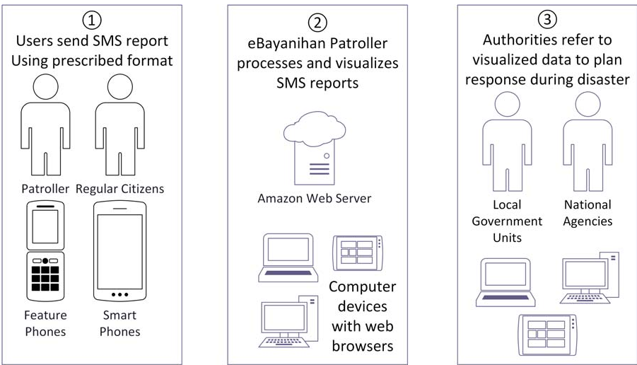 Fig 1: The flow from constituent reporting to authority response.
3. Visualization
Using the Google Maps API, reports are displayed with urgency-specific colors (e.g., orange for urgent). Keywords (e.g., "Flood," "Fire") are converted into intuitive icons.
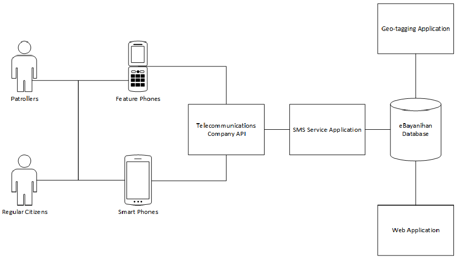 Fig 2: The database-centric architecture connecting SMS gateways to the web interface.
Experiments & Results: Real-world Stress Test
The system was tested during Super Typhoon Rammasun (Glenda) in July 2014.
- Functionality: The system successfully geolocated and visualized incoming reports at the barangay level.
- The Adoption Gap: Despite reaching 1,732 people on Facebook, only 13 reports were submitted. This highlights a common hurdle in crowdsourcing research: the "Participation Inequality."
- Limitations: The research identified that when multiple reports come from the same barangay, icons "stack" on top of each other, making the map hard to read—a classic visualization challenge in GIS.
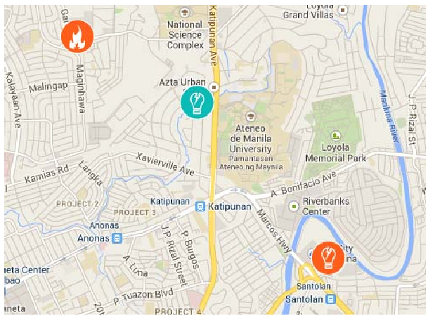 Fig 3: Real-time visualization of reports on Google Maps.
Critical Insight & Conclusion
The true value of eBayanihan is not just the technology, but its alignment with the Bayanihan spirit (communal unity).
Key Takeaways:
- Context is Queen: In regions with low internet penetration, SMS is not "old tech"—it is the only reliable tech.
- Trust Over Crowds: Spontaneous crowdsourcing is hard to achieve. Future efforts should focus on training "authorized patrollers" who are already part of the LGU structure to ensure a steady, reliable data stream.
- Visualization Matters: Turning 400 text messages into 400 points on a map significantly lowers the cognitive load for disaster responders.
Future Work: The authors suggest incorporating automated verification (to prevent fake reports) and more granular geolocation data (street-level) to improve response precision.