
Real-Time Violence Mapping: Transforming Mobile Devices into Personal Safety Navigators
System Development for Violence Mapping in a Social Network in Real Time
The paper proposes a real-time violence mapping system for São Paulo, Brazil, integrated into a social network on the Android platform. By leveraging GPS data and user-reported incidents, it provides live safety warnings and identifies risk points to assist with urban navigation.
TL;DR
This paper introduces a real-time mobile solution for mapping urban violence in São Paulo. By integrating GPS technology, social networking, and Android's proximity alerts, the system moves beyond outdated annual crime statistics to provide citizens with live, location-aware safety warnings during their daily commutes.
Context: The Static Information Gap
In major metropolitan hubs like São Paulo, violence is dynamic; a "safe" neighborhood can shift into a "high-risk" zone within hours. The authors identify a critical failure in current safety infrastructure:
- Outdated Data: Most official statistics are a year old.
- Accessibility Issues: Web-based maps are difficult to consult while driving or walking.
- Lack of Proactivity: Existing tools require the user to look for danger, rather than the device alerting the user.
Methodology: Engineering Proactive Safety
The core of the system lies in its ability to translate geographic coordinates into actionable safety alerts on the Android Platform.
1. The Haversine Challenge
Because the Earth is a sphere, simple Euclidean geometry (hypotenuse calculation) results in significant errors over distances exceeding 10km. The researchers implemented the Haversine Formula to ensure precision. However, since mobile versions of SQLite at the time lacked native trigonometric functions, the authors used a clever workaround: pre-calculating Sines and Cosines in Java and storing them in the database to simplify the SQL execution.
2. Proximity Alerting (The "Intents" Mechanism)
The system doesn't just show points on a map; it monitors the user’s trajectory. By utilizing the addProximityAlert method of the LocationManager class, the app defines a "safety radius" around known risk points.
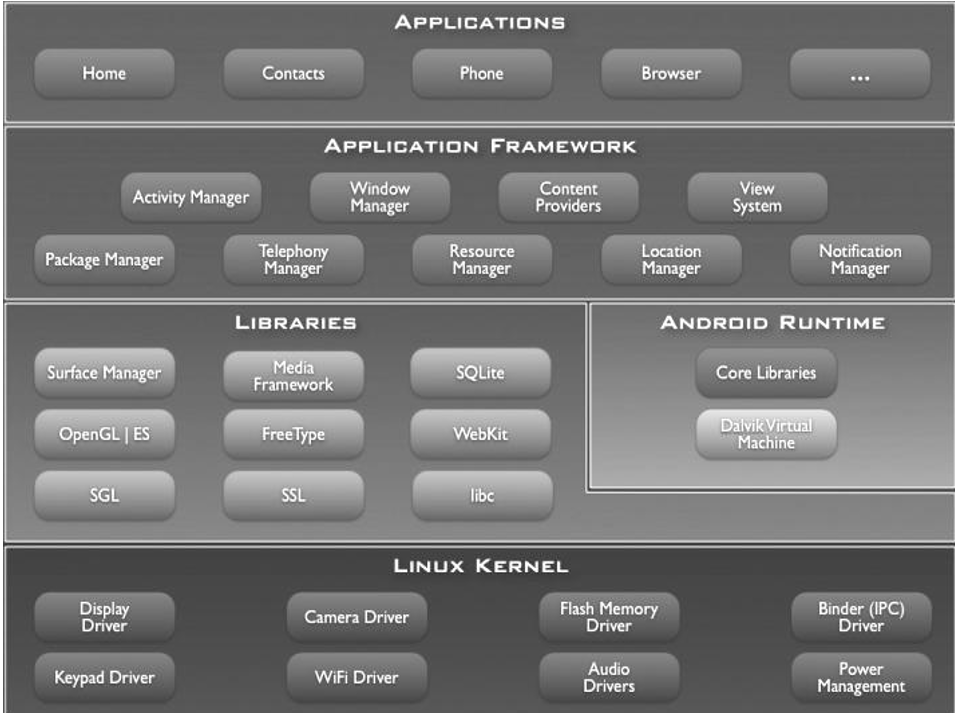 Figure 1: The Android System Architecture used to manage background location services and intent-driven alerts.
Experiments & Technical Implementation
Development was standardized using a virtual machine environment with the Android SDK and Eclipse. A critical finding in the development phase was the "power-accuracy" trade-off:
- Optimization: Updates are triggered based on a minimum distance traveled and elapsed time.
- Battery Preservation: When the device is in standby, the
LocationManagerreduces alert frequency to once every 4 minutes to prevent battery drain.
Crime Categorization
The researchers structured the risk points based on specific crime types to provide context-aware alerts:
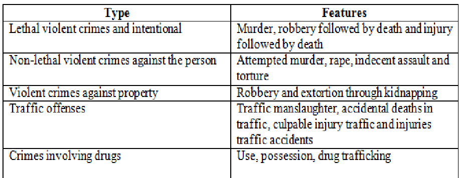 Table 1: The classification of risk events used to populate the real-time map.
Critical Analysis & Conclusion
The real value of this work is its Social Learning Network approach. By moving safety data into a social context, the system allows for real-time updates that government records simply cannot match.
Limitations:
- Data Reliability: Relying on user input introduces the risk of "false positives" or malicious reports.
- Connectivity: In 2011-2012 (the paper's era), constant data connection in Brazil could be a bottleneck.
Future Outlook: This architecture paves the way for modern "Waze-like" safety apps. Integrating this with AI to analyze the sentiment of social media feeds (e.g., Twitter) could further automate the detection of violent events before they are officially reported.
Takeaway
Urban safety is no longer just a policing issue; it is a data-processing challenge. This system demonstrates that by combining GIS, mobile persistence (SQLite), and intent-based architectures, we can create a protective digital layer over the physical city.