
Mapping the Truth: Unleashing Regional Association Rules in Spatial Data
On Regional Association Rule Scoping
This paper introduces a reward-based region discovery framework for Regional Association Rule Scoping, utilizing the SCMRG (Supervised Clustering using Multi-Resolution Grids) algorithm. It identifies localized spatial subspaces where specific association rules hold true, even when those rules fail to meet global support or confidence thresholds.
TL;DR
In spatial data, "global averages" are often lies. A rule that seems irrelevant statewide might be a life-saving insight in a specific county. This paper presents a framework to discover the spatial scope of these hidden patterns—specifically identifying "arsenic risk zones" in Texas that traditional global mining techniques completely overlook.
The Illusion of Global Statistics
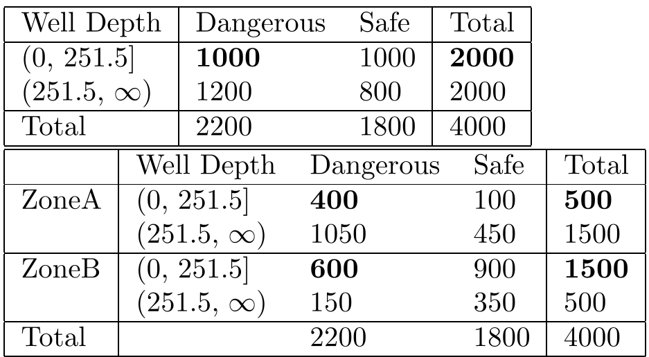
Most spatial relationships are geographically regional rather than global. The "average place on Earth" simply doesn't exist. In data science, this manifests as a high-stakes version of Simpson's Paradox: a trend appears in several different groups of data but disappears or reverses when these groups are combined.
For instance, an association between shallow well depth and arsenic levels might have 80% confidence in South Texas but drop to 40% at the state level (see Table 1). If you set your mining threshold to 70%, you miss a localized crisis.
Methodology: Reward-Based Scoping
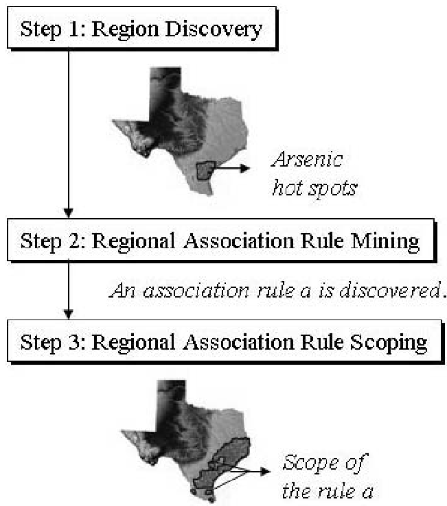
The authors move away from "hard" global filters, proposing a dual-purpose framework:
- Identify Regions: Use clusters to find where rules originate.
- Determine Scope: Use the rules to define the boundaries where they remain valid.
The heart of the approach is the Interestingness Function . Unlike traditional "pass/fail" thresholds, it uses a soft-thresholding mechanism. Even if a region's support is slightly below the limit, it can still receive a high "reward" if its confidence is exceptionally high.
The SCMRG Algorithm
The framework utilizes SCMRG (Supervised Clustering using Multi-Resolution Grids). It's a top-down, hierarchical approach that partitions space into grids, only subdividing them if the "reward" (fitness) increases at a higher resolution. This ensures the discovered regions are statistically significant and non-redundant.
Case Study: The Arsenic Crisis in Texas
The researchers applied this to the Texas Ground Water Database. While global analysis failed to find strong predictors for dangerous arsenic levels (>), the regional scoping method localized four critical zones:
- Zone 1 (High Plains): Linked shallow wells and high nitrate levels to arsenic risk.
- Zone 3 (Gulf Coast): Identified unique chemical triggers valid only in that specific coastal geography.
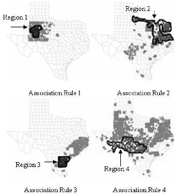
As shown in the figure above, the "Scope" (blue areas) often extends beyond the initial discovery region, providing a visual map of where a specific environmental "rule of thumb" can be safely applied.
Critical Analysis & Takeaways
This work highlights a critical Inductive Bias in spatial mining: spatial proximity matters.
Strengths:
- Robustness: Uses soft thresholds to prevent "cliff effects" where a tiny data change destroys a rule.
- Efficiency: Under 5 seconds for complex spatial clustering is impressive for large-scale geographic data.
Limitations:
- The method relies on a user-defined parameter to balance region size vs. reward, which might require domain expertise to tune.
Conclusion: Regional Association Rule Scoping isn't just about water quality; it's a blueprint for any field where "location, location, location" dictates the data. By defining the spatial boundaries of truth, we can build more reliable, localized AI systems.