
MapReduce & Speed-Breakers: A Low-Cost Recipe for Traffic Sensing in Developing Cities
Road congestion sensing via crowdsourcing and MapReduce
The paper proposes an event-driven crowdsourcing framework for road congestion sensing, utilizing speed-breakers as triggers for data collection. By employing a parallel MapReduce algorithm to process spatial data into "lane-level" analytics, it achieves an 85.71% accuracy in congestion estimation.
TL;DR
Managing urban traffic in developing nations is often hindered by the prohibitive cost of physical sensors. This paper introduces an ingenious crowdsourcing framework that transforms speed-breakers into "smart triggers." By collecting data only at these specific points and processing it via MapReduce, the authors achieve 85.71% accuracy in congestion detection while keeping data costs and computational overhead significantly lower than traditional GPS-tracking apps.
Problem & Motivation: The Redundant Data Trap
Most traffic apps like Google Maps or Waze rely on continuous GPS updates. While effective, this approach has two major flaws in the context of developing regions:
- Network & Battery Drain: Continuous data transmission is expensive for users and kills smartphone batteries.
- Data Redundancy: Constant polling generates vast amounts of overlapping data that doesn't necessarily add value to traffic pattern analysis.
The authors recognized that in cities like Patna, India, speed-breakers are ubiquitous. Instead of fighting these road features, they decided to use them as natural "checkpoints" to discretize the road network into logical segments or "lanes."
Methodology: Event-Driven Logic
The core innovation lies in the Shift from Continuous to Event-Based Sensing.
1. The Speed-Breaker as a Trigger
The system detects speed-breakers using the phone's accelerometer. When a vehicle hits a bump, the sensor records an upward impulse followed by a free fall. This specific signature triggers the collection of a small data payload: Location, GPS Bearing, and Average Speed since the last bump.
2. Discretizing the Road Network
The road is modeled as a graph where:
- Vertices (V): Speed-breakers.
- Edges (E): The road segment (lane) between two speed-breakers.
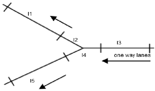 Fig 1: Modeling road segments as lanes defined by speed-breaker markers.
3. Analytics via MapReduce
To handle data from thousands of users, the authors use MapReduce.
- Map Phase: Organizes raw database dumps by User ID.
- Reduce Phase: Sorts timestamps and identifies the specific "Lane ID" (the path between two speed-breaker IDs) a user traversed, calculating the mean speed for that segment.
Experiments & SOTA Results
The system was tested on the streets of Patna, India, across various road widths (single-lane to 4-lane roads).
By comparing the average speed and number of vehicles against predefined thresholds (derived from road width), the system classifies traffic into three states: No Congestion (Green), Medium (Yellow), and High (Red).
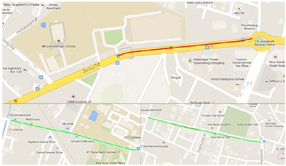 Fig 2: Visualization of real-world congestion levels in Patna.
| Road Width (m) | Avg. Speed (mps) | No. of Vehicles | Resulting Level |
|---|---|---|---|
| <= 3.75 | < 4.1 | > 10 | Medium |
| <= 3.75 | < 2.8 | > 20 | High |
Performance Metrics:
- Accuracy: 85.71% (based on a confusion matrix of 70 test cases).
- Efficiency: Significantly reduced data packets compared to traditional 1-second interval GPS polling.
Critical Analysis & Future Outlook
The beauty of this research is its context-awareness. It understands that in infrastructure-poor areas, "bugs" (speed-breakers) can be "features" (sensors).
Limitations:
- The system currently relies on manual threshold setting (as seen in the table above).
- It assumes a single driver per vehicle with the app active.
- False positives (10 out of 70) often occur due to GPS inaccuracies or erratic driving not related to congestion.
The Road Ahead: The authors suggest that replacing static thresholds with a Machine Learning classifier could further push accuracy beyond 90%. Furthermore, this model could be extended to detect road quality (potholes) simultaneously, creating a multi-purpose urban sensing tool.
Conclusion
By blending mobile crowdsourcing with the heavy-lifting capabilities of MapReduce, this paper provides a blueprint for "Frugal Innovation" in Intelligent Transportation Systems (ITS). It proves that we don't need million-dollar cameras to solve traffic; sometimes, we just need to listen to the bumps in the road.