
Scaling Urban Mapping: High-Resolution Settlement Extraction via Landsat and GEE
Scaling up to National/Regional Urban Extent Mapping Using Landsat Data
This paper introduces a scalable methodology for national and regional urban extent mapping at 30-m resolution using Landsat 5/7 data and the Google Earth Engine (GEE) platform. The core approach utilizes the Normalized Difference Spectral Vector (NDSV) combined with ensemble supervised classification (CART, SVM, Random Forest) to produce consistent human settlement layers.
TL;DR
Researchers have developed a robust framework for mapping human settlements at a 30-meter resolution across national and regional scales. By leveraging Landsat data, the Google Earth Engine (GEE) platform, and a specialized spectral feature called NDSV, this methodology overcomes the limitations of coarse-resolution global products (like MODIS) and the computational hurdles of high-resolution data processing.
The Resolution Gap in Global Urban Mapping
For years, the "gold standard" for global urban datasets resided at 300m to 500m resolutions. While useful for global climate models, these products fail to capture the granular reality of urban sprawl, missing small rural villages and providing "blurry" boundaries for mega-cities.
The transition to 30m Landsat data was historically hindered by three factors:
- Noise: Variations in atmosphere, illumination, and cloud cover across different scenes.
- Training Scarcity: The impossibility of manually labeling training data for every region on Earth.
- Compute: The sheer processing power required to handle thousands of multispectral scenes.
Methodology: The NDSV and Ensemble Approach
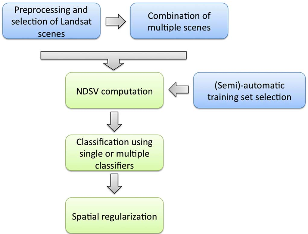
The authors solve these challenges through a systematic pipeline that prioritizes spectral invariance and computational efficiency.
1. NDSV: Finding the Urban Fingerprint
Instead of raw bands, the study uses the Normalized Difference Spectral Vector (NDSV). By calculating the ratio for all band combinations, they create a 15-dimensional feature space.
- The Intuition: Urban materials (concrete, asphalt) tend to have a "flat" NDSV profile, while vegetation shows high variability. This makes NDSV highly robust across different seasons and sensors.
2. The "Greenest Pixel" Strategy
To handle clouds and seasonal noise, the researchers utilize a "Greenest Pixel" composite. By selecting the pixel with the highest NDVI (vegetation index) over a time period, they maximize the contrast between natural "green" surfaces and artificial "gray" surfaces, making it easier for the classifier to distinguish a park from a parking lot.
3. Smart Training & Ensemble Learning
To automate the training, the system uses "buffer zones" around existing coarse maps (like GlobCover). It samples "pure" urban points far inside known cities and "pure" rural points far outside. These points train an ensemble of CART, SVM, and Random Forest classifiers. A majority vote (hard fusion) determines the final pixel class.
Experimental Results: Precision at Scale
The method was tested across diverse landscapes: the dense metros of Brazil, the rapidly expanding fringes of South East China, and the archipelago of Indonesia.
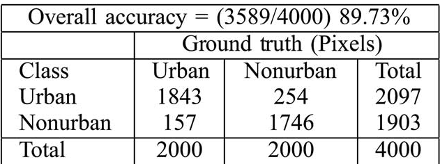
- Sao Paulo Performance: Initial pixel-level classification faced high omission errors because urban greenery was flagged as "non-urban." However, by applying a spatial morphological "close" operator (post-processing), the accuracy jumped from 71% to 90%.
- Java, Indonesia: The study successfully mapped the entire island of Java by processing 258 Landsat scenes. The researchers found that combining results from "quarterly" composites yielded better results than a single yearly composite, as it better managed persistent cloud cover.
Critical Insight: The GEE Trade-off
An important takeaway from this work is the trade-off between radiometric integrity and computational efficiency. While GEE's "Collection" approach (median/greenest pixel) is fast, it can alter spectral properties. The authors note that for maximum accuracy, analyzing scenes individually and then fusing the results is superior, though it requires significantly more compute–a balance researchers must hit based on the scale of their task.
Conclusion
This work provides a blueprint for high-resolution regional mapping. By moving away from "manual adjustments" and toward automated spectral-spatial processing, it paves the way for a consistent, 30-meter global urban layer that could redefine how we understand human distribution and environmental impact.
Future Work: The next frontier involves integrating SAR (Radar) data to penetrate cloud cover in tropical regions and utilizing Deep Learning to capture the texture of urban areas beyond simple spectral ratios.