
Sen4AgriNet: Bridging the Gap in Large-Scale Agricultural Earth Observation
Sen4AgriNet: A Harmonized Multi-Country, Multi-Temporal Benchmark Dataset for Agricultural Earth Observation Machine Learning Applications
Sen4AgriNet is a comprehensive, multi-country, and multi-temporal benchmark dataset for agricultural Earth Observation, containing 42.5 million labeled parcels from 225,000 Sentinel-2 patches. It harmonizes crop taxonomies across France and Spain based on FAO standards and provides two distinct formats: Object Aggregated (OAD) for classification and Patches Assembled (PAD) for semantic segmentation.
TL;DR
Sen4AgriNet is a new gold-standard benchmark dataset for agricultural AI, featuring 42.5 million parcels across multiple years (2016-2020) and countries. By harmonizing diverse European Land Parcel Identification Systems (LPIS) into a unified FAO-based taxonomy, it provides the backbone for training deep learning models that can finally generalize across spatial and temporal dimensions in smart farming.
Problem & Motivation: The "Tower of Babel" in Agricultural Data
While satellite constellations like Sentinel-2 provide a constant stream of spectral data, supervised learning for agriculture has historically been hampered by two factors:
- Fragmented Labelling: Every EU country maintains its own LPIS, often in local languages and using non-standardized crop categories.
- Temporal Neglect: Many existing remote sensing benchmarks (e.g., BigEarthNet) provide static snapshots, failing to capture the phenology (the seasonal growth cycle) that distinguishes a wheat field from a barley field.
The authors' insight was to tap into the recently opened farmer declaration data, treating it as high-fidelity ground truth, and mapping it to a universal English nomenclature.
Methodology: OAD vs. PAD
The dataset is split into two specialized formats to support different types of Deep Learning (DL) architectures:
- Patches Assembled Dataset (PAD): Designed for computer vision tasks like semantic segmentation. It maintains the raw pixel structure across 13 spectral bands, allowing models like Mask R-CNN to learn spatial boundaries and parcel geometry.
- Object Aggregated Dataset (OAD): A more computationally efficient "tabular" time-series format. It stores zonal statistics (mean, standard deviation, skewness) per parcel. This is ideal for Recurrent Neural Networks (RNNs) or LSTMs to focus on spectral shifts over a growing season.
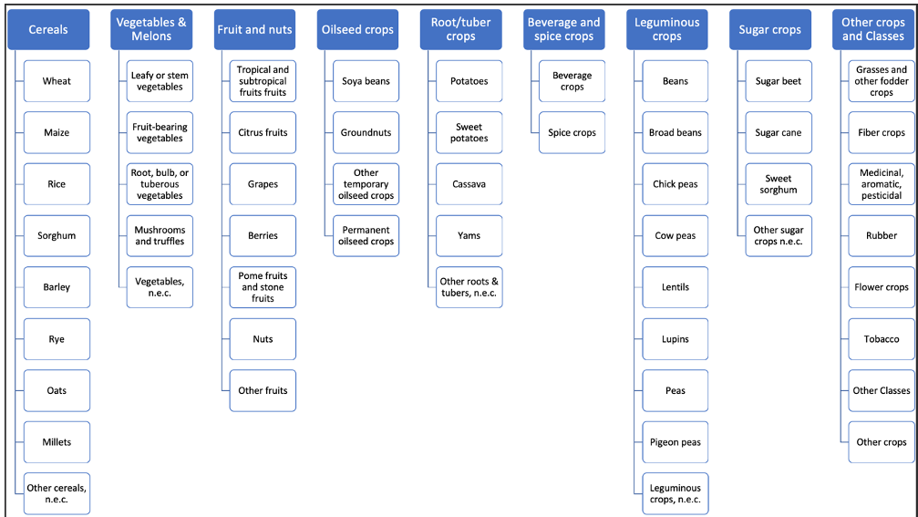 Figure 1: The hierarchical taxonomy used to harmonize labels across France and Spain.
Experiments & Results: Capturing the Pulse of the Field
The researchers benchmarked several architectures on the Catalonia 2020 subset.
1. Crop Mapping (PAD)
Using Mask R-CNN and DuPLO (a hybrid CNN-RNN), they treated parcel extraction as an instance segmentation problem. DuPLO achieved a superior result of 81.01%, showcasing that temporal awareness is vital even for spatial tasks.
2. Crop Type Classification (OAD)
For classifying the specific crop type (among 27 classes), the LSTM outperformed a basic Multi-Layer Perceptron (72.95% vs 69.43%). This confirms that the "memory" of previous spectral states is crucial for distinguishing crops with similar peak-growth signatures.
| Model Architecture | PAD Performance (F1) | OAD Performance (Acc) |
|---|---|---|
| Mask R-CNN | 75.30 % | - |
| DuPLO | 81.01 % | - |
| MLP | - | 69.43 % |
| LSTM | - | 72.95 % |
 Table 1: Comparative performance of various DL architectures on Sen4AgriNet.
Critical Analysis & Conclusion
Sen4AgriNet is a monumental step toward automated CAP (Common Agricultural Policy) monitoring. Its scale—10 TB of data—dwarfs previous agricultural datasets like BreizhCrop.
Limitations:
- The dataset currently relies on optical Sentinel-2 data, which is susceptible to cloud cover.
- The harmonization is currently limited to two regions (Catalonia and France), though the methodology is designed for expansion.
Future Outlook: The integration of radar data (Sentinel-1) will be the next frontier, providing a cloud-penetrating "all-weather" view of European agriculture. For practitioners, Sen4AgriNet represents a unique opportunity to build models that don't just work on one farm, but across an entire continent.
Takeaway
If you are building AI for the Earth, labels are your scarcest resource. Sen4AgriNet provides the first unified "dictionary" and "library" to solve agricultural classification at a continental scale.