
Sentinel-2 & Machine Learning: Modernizing the Common Agricultural Policy (CAP) Monitoring
An operational Sentinel-2 based monitoring system for the management and control of direct aids to the farmers in the context of the Common Agricultural Policy (CAP): A case study in mainland Portugal
The paper introduces an operational automated monitoring system based on Sentinel-2 time series and Machine Learning (Random Forest and SVM) to validate farmer subsidy claims under the EU's Common Agricultural Policy (CAP). Applied to mainland Portugal, the system effectively distinguishes compliant (green), non-compliant (red), and inconclusive (yellow) parcels, achieving a classification that matches field inspections with high reliability.
TL;DR
European agriculture is undergoing a digital transformation. This paper presents an operational system for mainland Portugal that replaces manual field inspections with an automated "traffic light" alert system using Sentinel-2 satellite data. By combining Random Forest (RF) for crop identification and Support Vector Machines (SVM) with texture analysis for refinement, the system achieves over 96% accuracy, drastically reducing the cost of administrative oversight while increasing coverage to 100% of parcels.
Background: Beyond the 5% Random Check
For decades, the Integrated Administration and Control System (IACS) relied on "On-the-spot checks" (OTSC). This meant sending inspectors to only 5% of farms to verify that what farmers claimed on their subsidy forms matched what was actually growing. The 2020 CAP reform invited a change: using "Monitoring by Observations." The challenge? Distinguishing 44+ types of crops in a landscape of small, oddly shaped parcels and varying climates across Portugal.
Methodology: The Hierarchical Approach
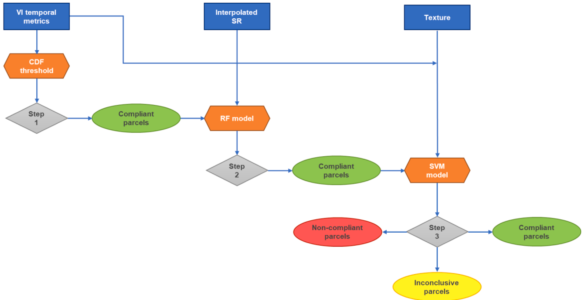
The authors don't just throw raw data at a model; they utilize a sophisticated three-stage pipeline to ensure reliability.
1. The Validation Filter
Before deep classification, the system checks if the "growth signal" exists. By analyzing the Maximum Gradient of the RedEdge Chlorophyll Index (CIRedEdge), the system can immediately spot if a declared temporary crop (like maize) lacks the characteristic rapid growth spike, filtering out "untruthful" declarations early.
2. Random Forest (RF) for Multi-class Mapping
The core classification utilizes 5-day interpolated Sentinel-2 Surface Reflectance.
- Why Interpolation? Clouds are the enemy of optical satellites. Linear interpolation ensures a consistent "feature space" of 279 dimensions (31 dates × 9 bands), allowing models trained in one year to be tested against another.
- Architecture: The RF model uses 100 trees to handle the high-dimensional data.
3. Refinement with SVM and Texture
A persistent pain point in remote sensing is the confusion between permanent crops (vineyards/olives) and certain temporary crops.
- The Insight: Use GLCM (Gray-Level Co-occurrence Matrix) Mean texture. Vineyard rows have a "repetitive linear structure" that looks distinct from the homogenous texture of a cereal field.
- The Model: An SVM classifier, which is inherently better at binary boundary separation (Permanent vs. Temporary), acts as a "referee" for inconclusive cases.
Experimental Results: Beating the "Statisticians' Error"
The system was tested against the 2019 Land Parcel Information System (LPIS) in Portugal.
| Metric | System Performance | EU Requirement |
|---|---|---|
| Type I Error (False Alarms) | 1.1% | < 5% |
| Type II Error (Missed Fraud) | 2.7% | 10% - 20% |
The integration of texture features specifically boosted the F1-score for olive groves to 0.97 and vineyards to 0.96, solving the primary misclassification trap of the RF-only stage.
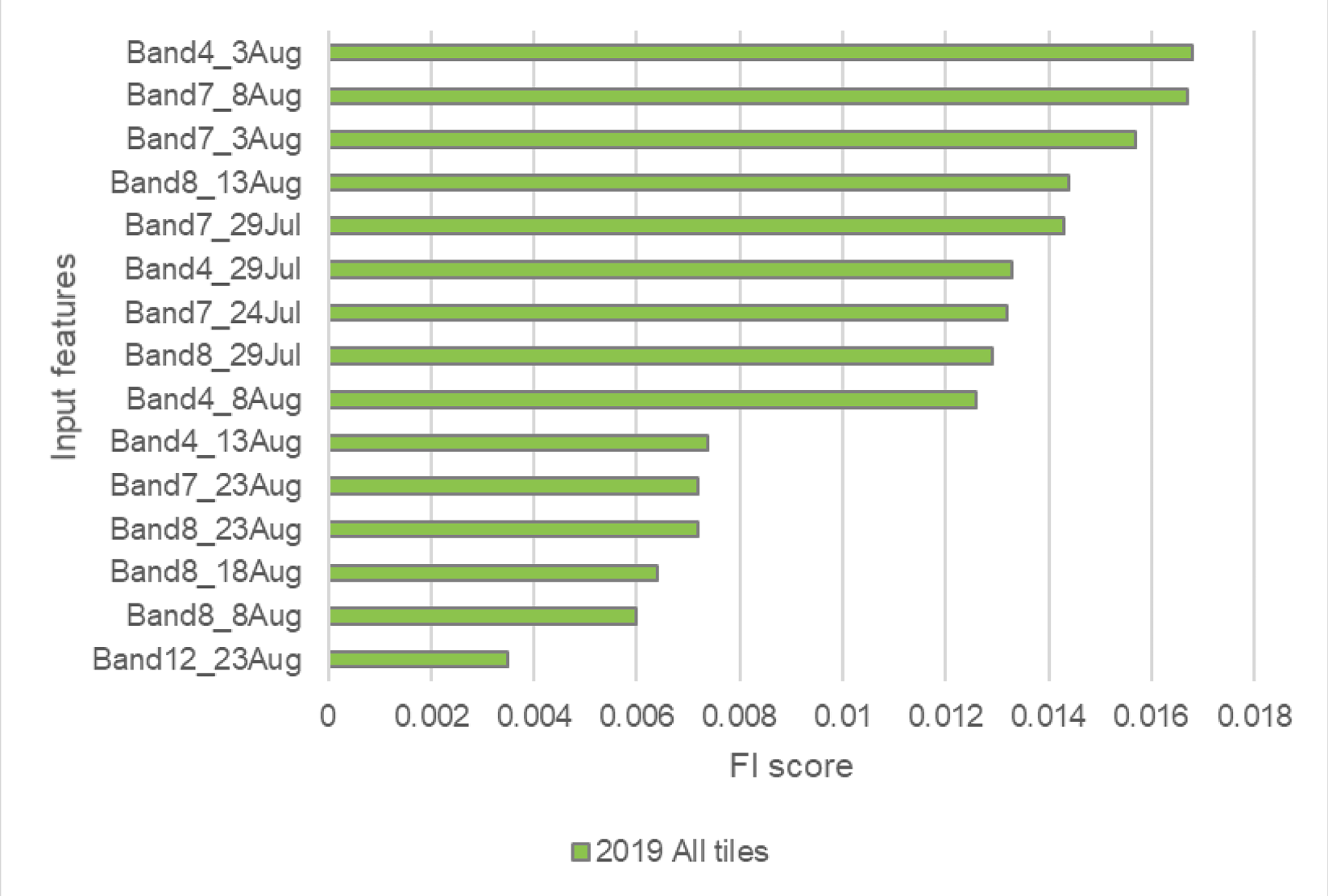 The figure above shows that features from late July to mid-August (crop maturation) are the most critical "fingerprints" for identification.
Critical Insight: The Transfer Learning Challenge
One of the most interesting findings was the "Transfer Learning" experiment. When the authors tried to use a model trained in the South (Alentejo) to predict crops in the North, the Kappa scores dropped by over 20%.
This highlights a major hurdle in AI for Earth Observation: Geographical Variance. Crop calendars shift, soil colors change, and parcel sizes vary. While the current system is "operational," future versions will need Domain Adaptation (adjusting model weights to new regions) to truly become a "plug-and-play" solution across Europe.
Conclusion
This Portuguese case study proves that the "Checks by Monitoring" approach is not just a theoretical goal but a viable technical reality. By flagging only 3.5% of parcels as inconclusive/non-compliant, Paying Agencies can focus their high-cost human resources on high-risk areas, ensuring a fairer and more efficient distribution of agricultural aid.
Key Takeaways for Practitioners:
- Texture Matters: Don't rely solely on spectral bands; GLCM features are essential for separating woody perennials from annuals.
- Temporal Consistency: 5-day linear interpolation is a robust "good-enough" solution for handling cloud gaps in operational pipelines.
- Mid-Season Readiness: The system achieves near-peak accuracy by August, allowing for proactive outreach to farmers before the claim season ends.