
Dynamic Soil Roughness: Enhancing L-Band Soil Moisture Retrieval
11409_A simple parameterization of the L-band microwave emission from rough agricultural soils.
This paper presents a simplified semi-empirical model for simulating L-band (1.4 GHz) microwave emission from bare soils, specifically tailored for agricultural landscapes. The authors propose a parameterization of the effective roughness as a function of both geometric properties () and surface soil moisture (), achieving high accuracy for soil moisture retrieval missions like SMOS.
TL;DR
Soil moisture retrieval from space relies heavily on correcting for surface roughness. This seminal paper by Wigneron et al. demonstrates that "roughness" in the eyes of a microwave radiometer isn't just about the physical height of soil clods—it's also about how moisture is distributed. By modeling the roughness parameter as a function of the profile slope () and volumetric soil moisture (), the authors provide a robust framework for L-band missions like SMOS.
The "Geometric vs. Dielectric" Challenge
In passive microwave remote sensing, the goal is to measure the Earth's brightness temperature () and extract the soil's dielectric constant, which is a proxy for moisture. However, a rough surface "traps" more radiation, making the soil appear warmer and wetter than it actually is.
Traditional models like the IEM (Integral Equation Model) are mathematically elegant but practically cumbersome; they require high-resolution laser profilometry that isn't feasible at a global scale. Conversely, simple semi-empirical models (like the model) often treat roughness as a static nuisance parameter. The authors argue that this is a mistake: because moisture affects the soil's volume scattering and "thermal sampling depth," the effective roughness changes as the soil dries.
Methodology: The PORTOS-93 Campaign
The study utilized the PORTOS radiometer mounted on a crane over seven agricultural plots in Avignon, France. These plots represented the full spectrum of agricultural conditions:
- Very Smooth: Rolled fields after sowing.
- Intermediate: Harrowed soils.
- Very Rough: Deeply plowed fields with large clods.
The Architecture of the Model
The core of the paper is the refinement of the reflectivity equation:
Where is the Fresnel reflectivity of a smooth surface. The breakthrough was in the parameterization of :
 Through extensive regression, they found that is best described by the ratio (the "slope" of the surface) modulated by the soil moisture .
Key Insights from Experiments
The researchers discovered a significant inverse relationship: Effective roughness increases as soil moisture decreases.
Why? The authors suggest "dielectric roughness." When soil dries, it doesn't dry uniformly. Clods dry faster than hollows, creating sharp dielectric discontinuities within the soil volume. Since L-band radiation penetrates deeper into dry soil (up to 10 cm), the sensor "sees" these internal heterogeneities as additional roughness.
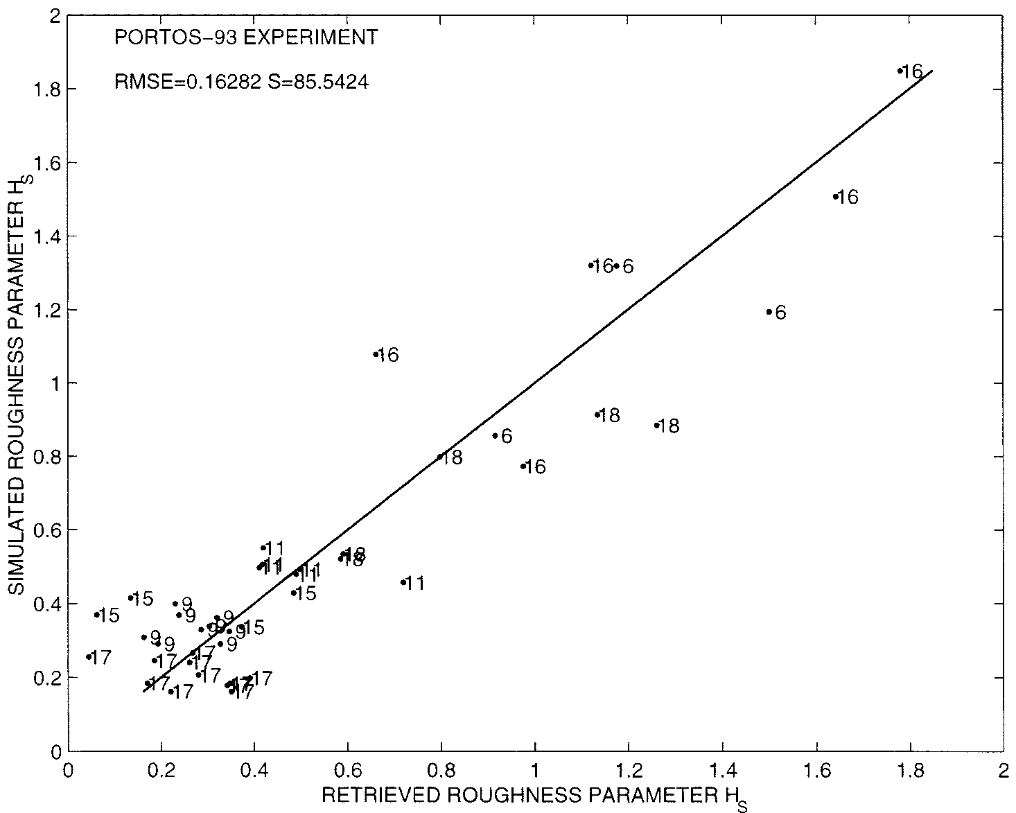 In the figure above, the comparison shows that including soil moisture in the parameterization (Case A) significantly tightens the correlation compared to using geometric markers alone (Case B).
Performance Metrics
Comparing the new model against the observed data:
- Accuracy: RMS error in emissivity was reduced to approximately 9.3 K.
- Consistency: The model remained valid across incidence angles (0–60°) and polarizations without needing site-specific tuning for each angle.
Critical Analysis & Future Outlook
This work shifted the paradigm from seeing roughness as a fixed physical state to a dynamic electromagnetic property.
Limitations:
- Isotropy: The model assumes isotropic roughness (no ridges). In real agricultural fields, row structure and tillage direction can introduce polarization-mixing effects () not fully captured here.
- Field 17 Anomaly: One field (road-rolled) showed significant deviation, suggesting that extremely compacted surface crusts might require additional "layered media" physics.
Takeaway for the Industry: For next-generation environmental monitoring, we cannot treat the Earth as a static surface. As we move toward global soil moisture maps via missions like SMOS, integrating moisture-dependent roughness corrections will be the difference between a "noisy" estimate and a scientific-grade data product.