
Socio-Graph: Bridging the Gap Between GPS Traces and Social Memories
Extraction of Social Context and Application to Personal Multimedia Exploration
This paper presents a framework for extracting social context (locations and relationships) from GPS and audio data to improve personal multimedia management. It introduces a density-based clustering method (DBSCAN) to identify "social spheres" and a novel mathematical formulation for "social tie strength" to categorize human interactions.
TL;DR
Researchers have developed a system that transforms "messy" GPS and audio logs into a social map of your life. By moving beyond simple timestamps, the "Socio-Graph" framework identifies significant locations like Home and Work and calculates the strength of your social ties to others, creating a multimedia browser that mirrors how human memory actually works: through people and places.
Background: The Digital Burden of Memories
We are capturing more photos and videos than ever, yet our ability to reminisce is hindered by the "digital burden." Existing tools organize media by folders or dates, but the authors argue that personal media is inherently socially situated. You don't remember a photo as "IMG_432.jpg from Oct 12"; you remember it as "that time at my sister's house with the kids."
The challenge lies in extracting these high-level social semantics from low-level, noisy sensor data.
Methodology: From Raw Coordinates to Social Spheres
1. Handling the "Noisy" GPS Reality
Standard clustering algorithms like k-means fail here because human movement doesn't happen in perfect circles. The authors utilize DBSCAN (Density-Based Spatial Clustering of Applications with Noise).
- The Insight: Significant places (Social Spheres) are areas where GPS points are dense over time.
- Preprocessing: They use interpolation to fill in "signal holes" (e.g., when you go indoors and lose GPS) and filter out high-speed data points to focus on where you actually stayed.
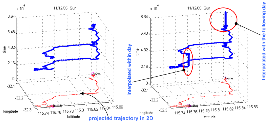 Figure 1: Comparison of raw GPS traces vs. interpolated data used to identify significant social stays.
2. Quantifying Human Connection: Social Tie Strength
The paper introduces a formalized measure of "Social Tie Strength" (). This isn't just about time spent together; it's weighted by the significance of the location.
- The Weighting (): A location is deemed more significant if you take more photos there. Time spent with a spouse at home (a high-media hotspot) counts more toward "tie strength" than time spent with a coworker at a random transit stop.
Experiments: Testing in the Real World
The study followed 5 users over 9 months. The algorithm successfully identified every single "ground truth" location provided by the users (Home, Work, Gym, etc.).
The Socio-Graph Browser
To prove the utility of this metadata, the authors built a 3D spatio-temporal browser. Unlike Picasa or PhotoMesa, Socio-Graph allows users to filter media by:
- Social Tie: "Show me photos of people I am close to."
- Presence: "Find photos where my brother was in the room (detected via audio)."
- Shared Places: "Show media from locations I visit with my best friend."
 Table 1: User study results showing Socio-Graph (lower score is better rank) significantly outperforming traditional browsers for social discovery tasks.
Critical Insight: Why This Matters
The most profound contribution of this work is the Social Tie Formulation. In 2006, this was a precursor to the "social graph" concepts later popularized by platforms like Facebook. It recognizes that our relationship with space is defined by the people we share it with.
Limitations
- Audio Privacy: The use of persistent audio for speaker ID is powerful but raises significant privacy concerns that have only become more sensitive today.
- Indoor Accuracy: While interpolation helps, the system still struggles with fine-grained indoor localization (e.g., which room of a museum you are in).
Conclusion
This research demonstrates that sensors can do more than just track coordinates; they can infer the texture of our social lives. By automating the extraction of "Home," "Work," and "Friendship," we move closer to a future where our devices understand the context of our memories as well as we do.