
SoNavNet: Bridging the Gap Between Social Media and Living Navigation
SoNavNet: a framework for social navigation networks
This paper introduces SoNavNet, a specialized Location-Based Social Network (LBSN) framework that integrates social networking with navigation services. Unlike traditional LBS or generic social networks, SoNavNet leverages user-generated trajectories, "friend-sourced" recommendations, and spatial annotations to provide personalized navigation experiences beyond simple shortest-path algorithms.
TL;DR
Published at the dawn of the smartphone era, SoNavNet is a visionary framework that transforms navigation from a lonely algorithmic calculation into a social, shared experience. By allowing friends to exchange custom routes, POIs, and "geofenced" alerts, it moves beyond the "shortest path" to the "best path" according to people you actually trust.
Context: This paper marks a pivotal shift from passive Location-Based Services (LBS) to active, user-generated Social Navigation Networks (LBSNs).
The "Shortest Path" Isn't Always the Best: The Motivation
In 2009, GPS was becoming ubiquitous in phones, but navigation was still robotic. Google Maps or MapQuest could tell you the shortest route, but they couldn't tell you that a certain intersection is a nightmare at 5:00 PM, or that a back-alley path is much more scenic for a walk.
The authors identified a critical gap: Trust and Personalization. We trust our friends' tastes in food; why not trust their expertise in the streets they drive every day? SoNavNet was designed to formalize this "spatial word-of-mouth."
Methodology: The Four-Layer Information Flow
The authors don't just build an app; they define an Ontology for social navigation. The core logic follows a vertical progression of data refinement:
- Position: Raw (x, y) coordinates from GPS.
- Location: Adding context (e.g., "123 Main St").
- Navigation: The layer of user-generated geometry (Routes, Geofences, POIs).
- Recommendation: The peak layer where social intelligence filters the navigation data for the user.
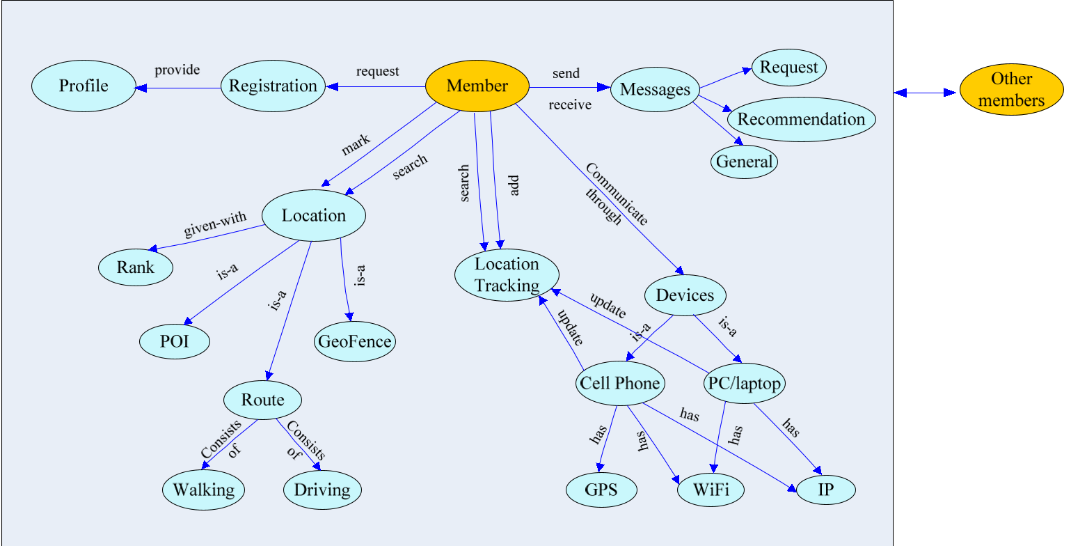 Figure 1: The SoNavNet Ontology, categorizing the relationships between members, spatial geometries, and functions.
The system architecture supports both mobile (Android) and desktop clients, using a centralized web server to manage the "Social Graph" and "Location History."
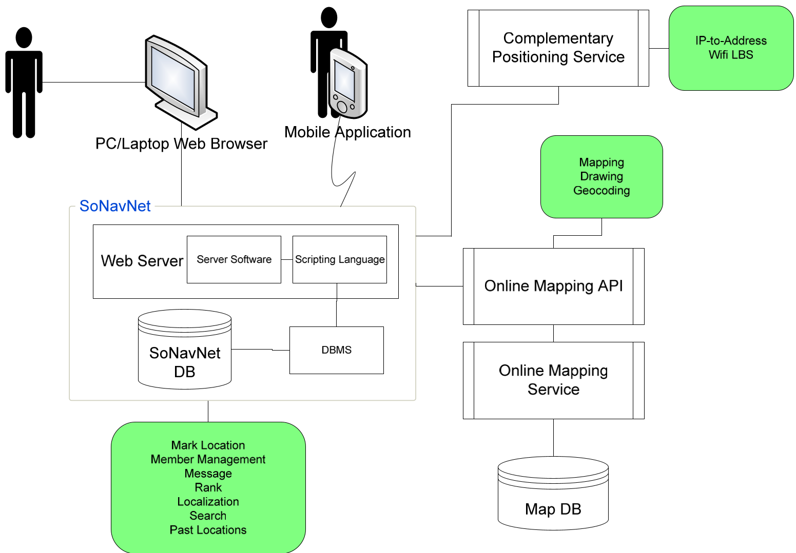 Figure 2: The system architecture, integrating GPS positioning, mobile applications, and mapping APIs.
Real-World Utility: The Prototype
The University of Pittsburgh team built a prototype to prove the concept.
- The Scenario: A user (Mary) asks for a Thai restaurant. A friend (Susan) draws a specific route on the map that avoids heavy evening traffic—a route a standard algorithm wouldn't prioritize.
- Ranking & Annotating: Every shared route or POI can be rated with a 1-5 star system, creating a "reputation" for spatial data.
- Trajectory Sharing: By sharing GPS tracks, users can see which friends are "experts" in certain neighborhoods based on how much time they spend there.
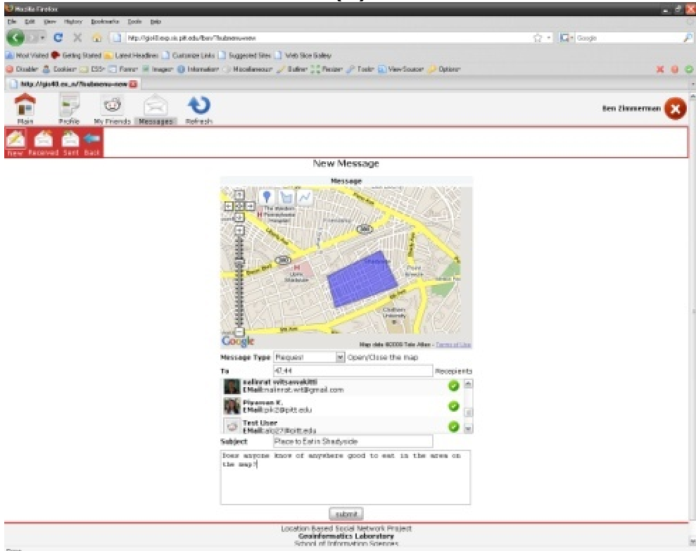 Figure 3: Screen showing a Request Form where users can ask for navigation help within a specific geofenced area.
Critical Insight: Beyond Just Finding a Restaurant
What makes SoNavNet fascinating is its extensibility. The authors correctly predicted that this framework isn't just for dining; it has massive implications for:
- Healthcare: Monitoring "geofences" for at-risk patients (e.g., survivors of suicide or those with dementia).
- Accessibility: Creating pedestrian networks for users with disabilities by sharing routes that avoid steep grades or stairs.
- Collaborative Mapping: Feeding user-generated tracks back into the system to improve map accuracy.
Conclusion & Future Outlook
While we take apps like Waze for granted today, SoNavNet provided the formal academic foundation for "Social Navigation." Its focus on the Member-to-Member (M-M) flow of spatial expertise remains a high-water mark for personalized LBS design.
Limitations: The paper reflects a pre-privacy-panic era. Today, the "Location Tracking" features would require much more robust encryption and granular permission settings to satisfy modern privacy standards (like GDPR).
Final Takeaway: Social Navigation isn't just about maps; it's about the Digital Credibility of the people providing the directions.