
Bridging the Sky and the Street: The Convergence of Remote Sensing and Social Media
11867_Spatial Technology and Social Media in Remote Sensing A Survey.
This survey explores the integration of social media content with remote-sensing-based spatial technologies. It identifies a new paradigm where "citizen sensors" provide high-velocity, geolocated data to complement traditional satellite Earth observation for real-time decision making.
TL;DR
The proliferation of GPS-enabled smartphones has turned billions of users into "citizen sensors." This paper surveys how geolocated social media (Twitter, Instagram, Flickr) is being fused with traditional satellite Remote Sensing and GIS to create a more responsive, high-resolution "Digital Earth." By combining authoritative satellite imagery with the real-time velocity of social media, researchers are overcoming the latency and visibility gaps of traditional Earth observation.
Problem & Motivation: The Latency of Authoritative Data
In the world of Remote Sensing, "authoritative data" (satellites, SAR, LiDAR) is the gold standard but often suffers from Temporal Latency. A satellite might not pass over a disaster zone for days, or thick cloud cover might obscure the optical sensors during a flood.
Conversely, Social Media provides Velocity and Variety, but lacks Veracity. Human-generated data is noisy, sometimes deceptive, and spatially irregular. The authors argue that the solution lies not in choosing one over the other, but in a Big Data Fusion framework that treats social media as a real-time ground-truth validation for remote sensing models.
Methodology: Mining the Geosocial Footprint
The paper breaks down the integration into a hierarchy of localization and fusion techniques:
1. Localization Hierarchies
To fuse a tweet with a satellite pixel, we must know exactly where the user is. The paper identifies three levels:
- IP/Browser Oriented: Coarse, city-level accuracy.
- Content-Driven: Using text (NLP) and visual features (CV) to infer location.
- Network-Based: Exploiting social proximity (who your friends are) to improve prediction accuracy.
2. General Fusion Framework
The authors highlight the transition from simple data overlay to "Synergistic Integration." This involves weight-based systems where authoritative data (satellites) are given high confidence weights, while social media data provides high-frequency "triggers" for deeper analysis.
 Figure 1: Conceptual overview of how social footprints associate with Earth Observation data.
Experiments & Success Stories: Natural Disasters and Urban Life
The survey provides a detailed taxonomy of applications where this fusion has proven superior to traditional methods.
- Flood Monitoring (São Paulo & Calgary): Researchers found that the volume of tweets corresponded linearly to the progression of floods. In cases where SAR or LiDAR data was limited, georeferenced photos from citizens provided "on-the-ground" verification of water levels.
- Urban Behavior: Using Foursquare and mobile network data to study human mobility patterns, which helps in urban heat island modeling and city planning.
Comparative Application Analysis
The following table summarizes the diverse data sources and application domains discussed in the paper:
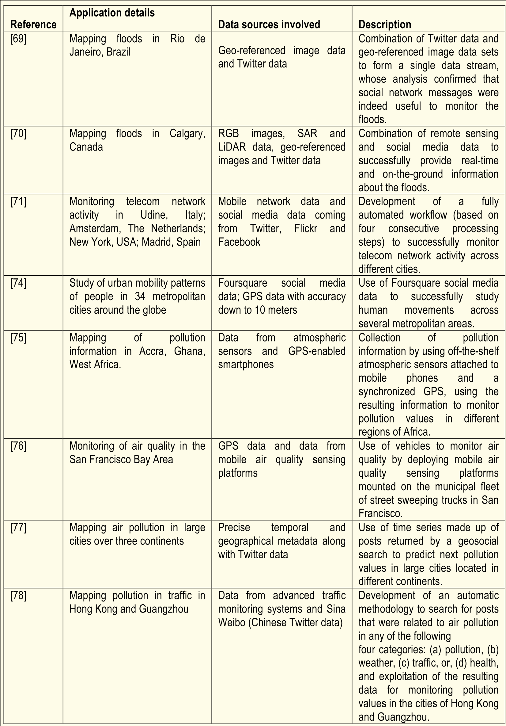 Table 1: Key references showcasing the integration of social sensors and physical sensors.
Critical Analysis & Future Outlook
The authors conclude that while the "Digital Earth" is becoming a reality, several hurdles remain:
- The Trust Issue: Deceptive information and "noise" in social media require more robust filtering algorithms.
- Computational Complexity: Processing petabytes of mixed image and text data requires advanced Cloud Computing and High-Performance Computing (HPC) architectures.
- The Semantic Gap: There is still a disconnect between what a machine sees (spectral reflectance) and what a human describes (a "heavy flood").
Takeaway
This paper marks a shift in Remote Sensing from a purely physical science to a socio-technical one. For future researchers, the focus will move from "getting better pixels" to "better understanding the human context" within those pixels.