
StopFinder: Bridging the "Last Ten Meters" for Blind Transit Riders via Crowdsourcing
StopFinder: improving the experience of blind public transit riders with crowdsourcing
StopFinder is a mobile-based crowdsourcing system designed to help blind public transit riders locate bus stops by providing information about non-visual landmarks (e.g., shelters, benches, garbage cans). The system leverages both sighted users via the OneBusAway app and blind users through a specialized iPhone interface to create a reliable database of stop environments.
TL;DR
StopFinder is an innovative research project from the University of Washington that addresses a critical gap in urban navigation: finding the exact location of bus stops. By using a dual-sided crowdsourcing model, the system collects data on non-visual landmarks (like the position of a bench relative to a trash can) to guide blind riders through a mobile interface, moving away from expensive specialized hardware toward ubiquitous smartphones.
The Problem: The Precision Gap in Public Transit
For most users, a GPS pin on a map is "close enough" to find a bus stop. For a blind rider navigating with a cane or guide dog, being five meters off can mean the difference between catching a bus and standing at a dead end.
Current limitations include:
- GPS Accuracy: Standard mobile GPS often lacks the pinpoint precision needed to find a specific pole on a busy street.
- Hardware Barriers: Previous solutions like Braille note-takers (e.g., GoBraille) are bulky and expensive.
- Data Scarcity: Static transit feeds (GTFS) provide stop locations but zero information about the physical environment, such as whether there is a shelter to wait in or a garbage can that serves as a tactile landmark.
Methodology: Two Worlds, One Data Stream
The core insight of StopFinder is its Asymmetric Crowdsourcing model. The author recognized that different users have different capabilities and time constraints.
1. The Sighted Interface (OneBusAway Integration)
To solve the "cold start" data problem, the author integrated StopFinder into OneBusAway, a popular real-time transit app.
- Mechanism: While sighted users wait for their bus, they engage with a "game-like" graphical interface.
- Task: They drag and drop icons (shelters, benches) onto a map to match the real-world layout.
- Conversion: This visual data is then algorithmically converted into descriptive text for blind users.
2. The Blind User Interface (iPhone/VoiceOver)
For the primary users, the focus is on ultra-efficient information retrieval.
- Mechanism: A non-graphical interface optimized for Apple’s VoiceOver (text-to-speech).
- Task: Users receive landmark descriptions and can provide feedback or new data through quick multiple-choice questions, minimizing the effort required while traveling.
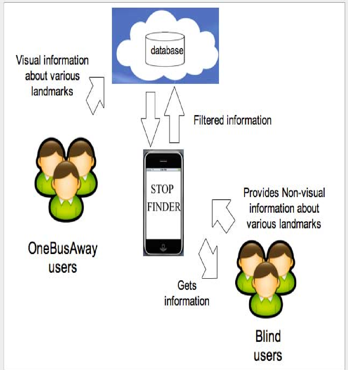 Figure 1: Workflow of the StopFinder system, showing the integration between sighted contributors and blind end-users.
Validation and Analysis
The research emphasizes Reliability and Human Factors. Because crowdsourced data can be noisy or incorrect, the system employs a Rating System. If multiple users contribute conflicting information about a stop, the higher-rated or most frequent description is prioritized.
The author poses several vital research questions for the field deployment phase:
- Does access to landmark data increase the frequency of public transit use among blind populations?
- Does it improve perceived safety and independence?
- Can a rating system effectively mitigate the risk of "vandalized" or incorrect crowdsourced data?
Critical Insights & Future Outlook
StopFinder represents a shift in Accessibility Research from "building tools" to "building ecosystems." By leveraging the idle time of sighted passengers, the system creates a sustainable way to map the "tactile world."
Perspectives:
- Why it works: It targets the Inductive Bias of the problem—visual users are good at spatial layouts, while blind users are experts at tactile landmark verification.
- Limitations: In 2011, the reliance on manual crowdsourcing was necessary. Today, one might wonder if Computer Vision (CV) could automate this, though the author’s focus on human-verified landmarks remains the gold standard for safety-critical navigation.
Conclusion
StopFinder is more than just an app; it is a framework for inclusive urban design. It proves that with the right interface, the "crowd" can provide the high-resolution environmental data that satellites and transit agencies simply cannot.
References
- Azenkot, S., et al. (2011). Enhancing Independence and Safety for Blind and Deaf-Blind Public Transit Riders. CHI '11.
- Ferris, B., et al. (2010). OneBusAway: Results from providing real-time arrival information. CHI 2010.