
From Fields to Pixels: How AI is Redefining Agricultural Land Classification
Survey on Machine Learning and Deep Learning Techniques for Agriculture Land
This review article systematically surveys the evolution of classification algorithms for agricultural land monitoring, transitioning from traditional field observations to advanced Deep Learning (DL) and Machine Learning (ML) techniques using multi-source remote sensing data (Sentinel, Landsat, MODIS). It highlights how hybrid architectures like DCNNs have achieved State-of-the-Art performance (up to 96% accuracy) in crop mapping and land-use categorization.
Executive Summary
TL;DR: This comprehensive survey serves as a strategic roadmap for the digital transformation of agriculture. By moving away from costly field surveys to satellite-based Deep Learning (DL) and Machine Learning (ML), researchers are achieving near-human precision in crop monitoring and land-use mapping.
Background Positioning: This article acts as a critical bridge between traditional Remote Sensing (RS) and the burgeoning field of Agri-Tech AI, positioning DL not just as a tool for classification but as a fundamental shift in how we interpret planetary-scale data.
Problem & Motivation: The Limits of Traditional Vision
For decades, agricultural monitoring was a labor-intensive, local endeavor. While early remote sensing introduced Per-pixel classification, these methods often fell into the "Mixed Pixel Trap"—where a single pixel contains a blend of soil, healthly crops, and weeds, confusing simple parametric models like Maximum Likelihood Classifiers (MLC). The core motivation of modern research is to overcome this "spectral confusion" by leveraging the spatial context (what's next to the pixel) and temporal patterns (how the pixel changes over the growing season).
Methodology - The Structural Evolution
The paper categorizes the evolution of classifiers into three distinct waves:
1. The Classical ML Wave (Supervised/Non-Parametric)
Algorithms like SVM (Support Vector Machines) and Random Forest (RF) introduced the ability to handle high-dimensional data without assuming a normal distribution. These models are effective for small datasets but struggle with the sheer scale of global satellite archives.
2. The Deep Learning Wave (The Feature Revolution)
Deep Learning (DL) changed the game by eliminating manual feature engineering.
- CNNs (Convolutional Neural Networks): Capture spatial relationships and textures, crucial for identifying crop rows and field boundaries.
- RNNs (Recurrent Neural Networks): Capture the "phenological signature"—the unique way a crop reflects light at different stages of its growth cycle.
3. Key Architecture Overview
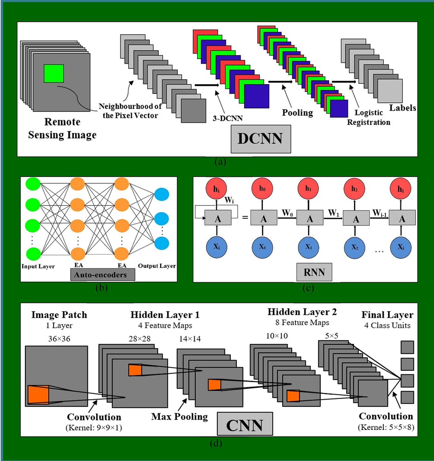 Figure 1: Comparison of DCNN, Auto-encoders, RNN, and CNN architectures for remote sensing tasks.
Experiments & Results: SOTA Performance
The paper aggregates performance data across various sensors (Sentinel-2, Landsat-8, Radarsat-2). A clear trend emerges: DCNNs (Deep Convolutional Neural Networks) consistently hit the 92-96% accuracy mark, particularly in complex multi-class scenarios where traditional decision trees fail.
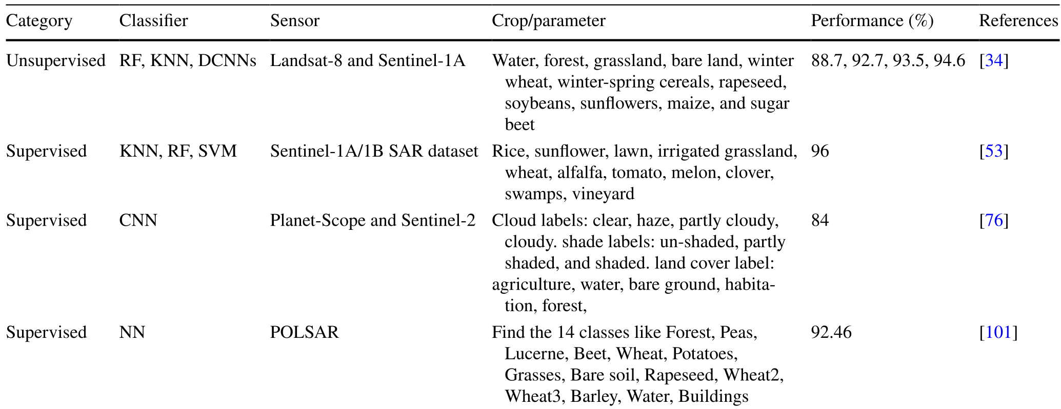 Table 5: Highlighting the 96% accuracy achieved by supervised DL models on Sentinel-1A/1B datasets.
Key Insights from Experimental Data:
- Robustness: DL models handle "cloud and shadow" noise better than traditional ML.
- Computational Cost: While training remains expensive, the inference speed on pre-trained DCNNs allows for rapid real-time mapping of entire states.
Critical Analysis & Conclusion
Takeaway
The integration of AI with remote sensing has moved from the laboratory to the industrial scale. The ability to identify 14+ different crop classes with >90% precision is now a reality.
Challenges & Future Work
Despite the success, the authors identify several "Hard Problems" yet to be fully solved:
- Data Hunger: Deep Learning requires massive amounts of labeled training data, which is scarce in developing economies.
- Transferability: A model trained on Indian wheat fields may fail on American corn belts due to different soil types and atmospheric conditions.
- Complexity: DCNNs are currently seen as "black boxes," making "Explainable AI (XAI)" a critical frontier for agricultural science.
Agricultural AI is no longer just about classification; it is about predicting the food security of the future.