
Events Describe Places: Unlocking PoI Semantics via Social Network Data
Events Describe Places: Tagging Places with Event Based Social Network Data
This paper introduces an automated approach for tagging Points of Interest (PoIs) by leveraging Event-Based Social Network (EBSN) data from Meetup. By applying Latent Dirichlet Allocation (LDA) to textual event data, the authors generate descriptive tags that outperform standard category markers, achieving significant semantic alignment with manually curated Foursquare tags.
TL;DR
Researchers have developed a way to automatically "tag" physical locations by eavesdropping on the social events held there. By analyzing data from Meetup using Latent Dirichlet Allocation (LDA), they produced descriptive keywords that match manual human annotations, effectively solving the metadata scarcity problem in location-based services (LBS).
The "Metadata Desert" in Geospatial Apps
When you search for a "quiet place to code" or a "technical research hub," most maps fail you. They might tell you a building is "Education" or "Office," but they lack the fine-grained tags like Python, Machine Learning, or Open Source that actually define the activity within.
The problem is twofold:
- Participation Gap: While millions visit these places, only a tiny fraction (roughly 7-10%) bother to write descriptive tags.
- Check-in Limitations: Previous SOTA methods relied on check-in data, which is often private or too sparse to provide rich semantic context.
The authors’ insight is elegant: People don't tag places, but they do describe the events they attend. If a "Computer Science Center" hosts numerous "Software Development" meetups, the text from those event descriptions and comments should naturally describe the place itself.
Methodology: From Events to Topics
The researchers constructed "Place Documents" by aggregating all textual data associated with events at a specific location, including:
- Group Profiles: Who is organizing the event?
- User Interests: What are the attendees interested in?
- Comments: What is the community saying?
Applying LDA and ESA
They used Latent Dirichlet Allocation (LDA) to uncover the hidden thematic structure of these documents. However, not every word in a topic is a good tag. To solve this, they used Explicit Semantic Analysis (ESA) to measure the "relatedness" between the generated words and 5.5 million Wikipedia concepts.

The figure above highlights the conceptual link between social event data and the physical location.
Key Finding: The Power of Top 3 Topics
The study discovered a specific "sweet spot" for tag extraction. Through a simulation of semantic relatedness scores, they found that:
- Topic Rank Matters: The first three topics generated by the model contain the vast majority of relevant information.
- Word Rank Matters: Within those topics, only the top 5 words maintain high semantic relevance to the actual location.
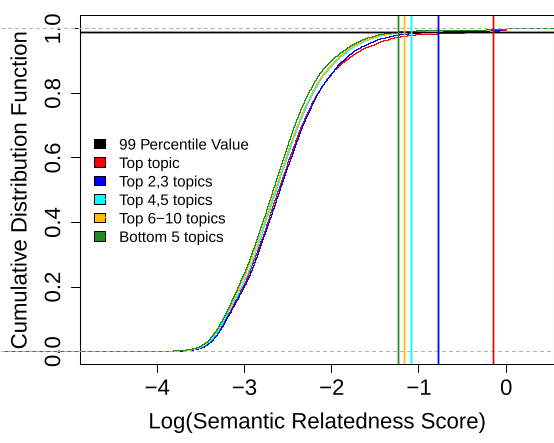 Figure (a) shows the sharp decline in semantic relatedness as topic rank increases, proving that the primary themes are the most descriptive.
Experimental Results
The authors validated their approach against Foursquare ground truth data.
| Venue Name | Derived Tags (LSO) | Foursquare Manual Tags |
|---|---|---|
| Adobe SF Offices | photography, software, technology, web... | flash platform, software development... |
| Arastradero Preserve | bicycling, biking, running, mountain... | biking, running |
The results were particularly strong for niche locations (research centers, specialized clubs, parks). However, the model struggled with "Generic" locations like Hotels, Food, and Transport. Why? Because a hotel hosts everything from wedding parties to tech conferences, making its "event profile" too noisy to define the building's primary purpose solely through text.
Critical Analysis & Future Outlook
This work provides a robust framework for Geographic Knowledge Discovery.
Strengths:
- Zero Supervision: Requires no manual labeling.
- Cross-Platform Potential: Can be integrated into Google Maps or OpenStreetMap to auto-populate descriptions.
Limitations:
- The Genericity Trap: As noted, generic venues require more than just text. The authors suggest that adding temporal data (e.g., when these events happen) could help distinguish a "Breakfast Cafe" from a "Nightclub" even if both host "Social Mixers."
Conclusion: This paper shifts the focus from what a place is (category) to what happens there (events). It proves that the "Geospatial Web" can be significantly enriched by simply listening to the social pulse of the people occupying its spaces.