
Toponym Resolution in Social Media: Leveraging the Social Graph to Solve Geographic Ambiguity
Toponym Resolution in Social Media
This paper presents a social-context-aware approach for Toponym Resolution—disambiguating location names in social media (e.g., Flickr). By expanding the context from a single piece of content to the user's personal history and their social network, the authors significantly improve geolocation accuracy for ambiguous terms.
Executive Summary
In the landscape of social media, a single tag like "Cambridge" is a riddle. Is the user in the UK, Massachusetts, or perhaps referring to a university brand? This paper, "Toponym Resolution in Social Media", tackles the inherent "information poverty" of individual posts by treating them as nodes within a broader social network. By moving beyond the text of a single photo and looking at the user’s history and their friends' tagging habits, the authors shift Toponym Resolution from a linguistic puzzle to a context-mapping exercise.
The study demonstrates that while document-level context is a decent baseline, integrating user-level data boosts F-scores by nearly 7%, providing a more robust framework for dealing with high-entropy, ambiguous terms.
The Problem: When "Barry" Isn't a Place
Toponym resolution faces two primary hurdles in the social media era:
- Lexical Ambiguity: One name (homonym) maps to dozens of physical coordinates.
- Referential Context: In informal media, a location name might actually be a person's name, a band, or a subjective descriptor.
Prior works often focused on natural language processing (NLP) of news articles where grammar provides clues. However, social media "tags" are just a bag-of-words. Without grammar, how do we know where "Sully" is?
Methodology: The Expanding Context
The authors’ core insight is the Hierarchy of Context. They argue that information is stored in layers:
- Document Level (D): Tags associated with the specific photo.
- User Level (U): The collective tagging history of the person who uploaded the content.
- Social Level (C): The tags used by the user's immediate contacts.
- Extended Social Level (CC): The tags used by the contacts of those contacts.
To power this, they used Yahoo! GeoPlanet, a semantic database that provides hypernyms (containing regions) and coordinate terms (neighboring towns). This allows them to build a "Geographic Feature Vector" for each post.
 Formula 1 & 2: Representing Information Context (IC) as a vector of related term frequencies and mapping it to a specific meaning (M).
Experiments and Results
The authors tested their hypothesis on Flickr data across three UK regions: Cambridge, Sheffield, and Cardiff.
Key Findings:
- User Context is King: For almost every location, moving from Document (D) to User (U) context resulted in a significant performance jump. This is because users are creatures of habit; if they live in Sheffield, their "Sheffield" tags almost always refer to the same UK city.
- Social Network Value: Adding immediate contacts (C) helped "smooth" data for less active users.
- The Law of Diminishing Returns: The "Contacts' Contacts" (CC) level actually decreased performance (Macro-average fell from 0.892 to 0.860), likely due to the "Small World" phenomenon introducing irrelevant geographic noise from globally dispersed networks.
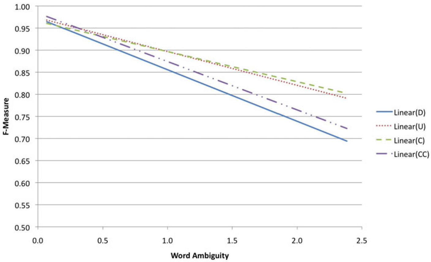 Figure 2: The trend lines show that while performance drops as ambiguity increases, methods using User (U) and Social (C) context are much more resilient than the Document-only (D) approach.
Detailed Performance Table
| Location Name | Term Ambiguity | Document (F1) | User (F1) | Contacts (F1) |
|---|---|---|---|---|
| Cardiff | 0.389 | 0.949 | 0.952 | 0.960 |
| Sheffield | 0.717 | 0.885 | 0.909 | 0.913 |
| Ferndale | 1.801 | 0.617 | 0.833 | 0.860 |
| Macro-Average | - | 0.832 | 0.891 | 0.892 |
Critical Analysis & Conclusion
Strongest Contribution: The paper successfully quantifies the "social benefit" in disambiguation. It proves that social media analysis cannot be purely text-centric; it must be user-centric.
Limitations:
- Data Currency: The study assumes that a user's social network is geographically clustered. In a globalized world, a UK user's contacts might be in the US, potentially confusing a local system.
- Resource Dependency: The system's "IQ" is capped by the Yahoo! GeoPlanet database, which the authors admit contained errors and missing suburbs in Sheffield.
Future Outlook: This work paves the way for modern "Social Graphs" used in recommendation engines. By combining this social context with Temporal Proximity (where was the user 5 minutes ago?), we can achieve nearly perfect toponym resolution in real-time applications.
Takeaway: In the world of Big Data, the best way to understand a single data point is to look at the network that surrounds it.