
Trace Analysis and Mining: The Digital Nervous System of Smart Cities
9592_Trace analysis and mining for smart cities issues, methods, and applications.
This paper provides a comprehensive taxonomical overview of trace analysis and mining for smart cities. It introduces a general framework for processing massive trace data from mobile devices and vehicles, utilizing methods like clustering and classification to optimize urban domains such as transportation and public health.
TL;DR
As cities grow increasingly complex, "trace data"—the spatial-temporal footprints left by humans and vehicles—has become the primary fuel for urban intelligence. This paper outlines a systematic framework for mining these footprints using machine learning and statistical physics to solve critical urban issues like traffic congestion and epidemic control.
Background & Motivation
Sustainable urbanization is one of the 21st century's greatest challenges. We have massive amounts of data from GPS, WiFi, and Smart Cards, but this data is often "noisy" and "low-level." The core problem is Semantic Gap: how do we turn a sequence of GPS coordinates into the understanding that "a group of people is attending a local festival" or "this region is transitioning from a residential to a commercial zone"?
The Technology Roadmap: From Raw Data to Intelligence
1. Heterogeneous Data Sources
The paper categorizes trace sources into four distinct pillars:
- Mobile Devices: WiFi/GSM/Bluetooth traces reflecting individual human movement.
- Vehicles: GPS traces that mirror both driver behavior and urban traffic flow.
- Smart Cards: Fixed-location consumption logs (swiping machines).
- Floating Sensors: Tracking specific objects like cargo (RFID) or even trash.
2. Core Mining Methodologies
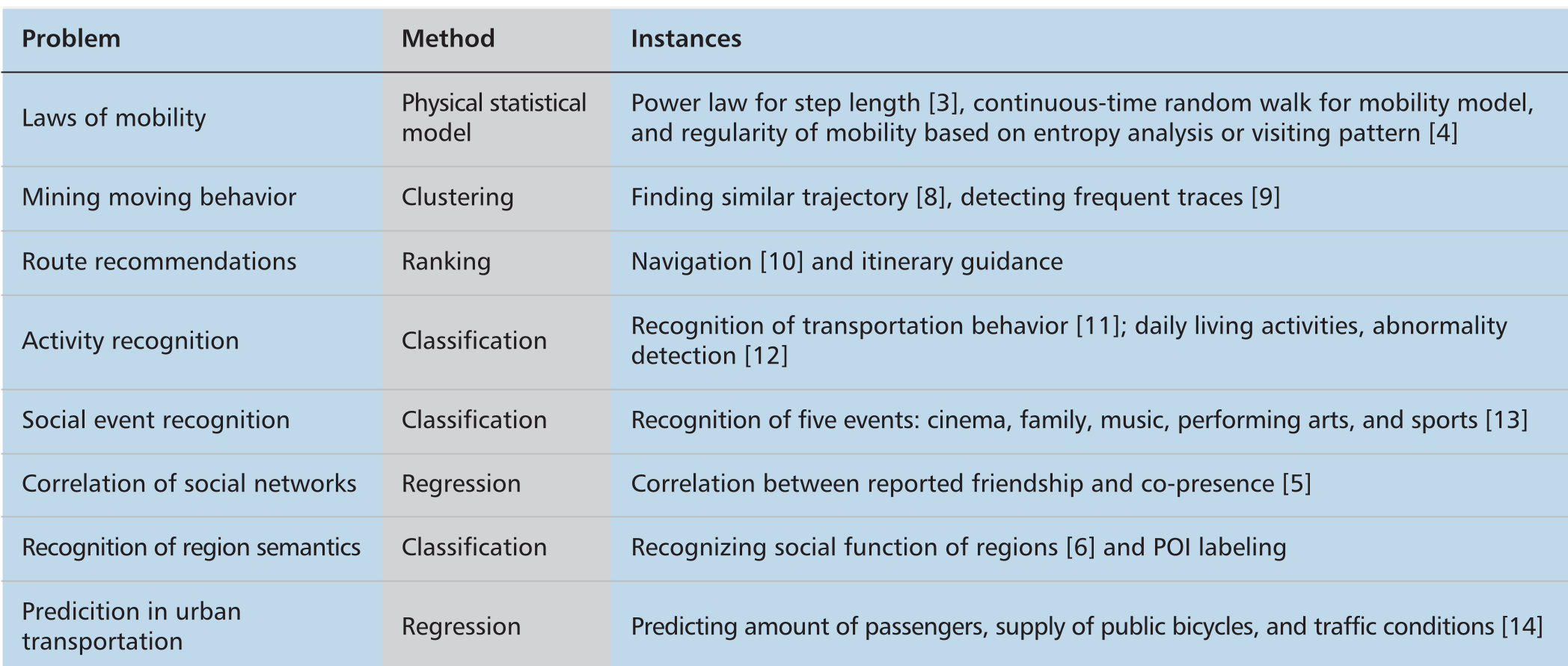
To process this data, the authors propose five tactical mining techniques:
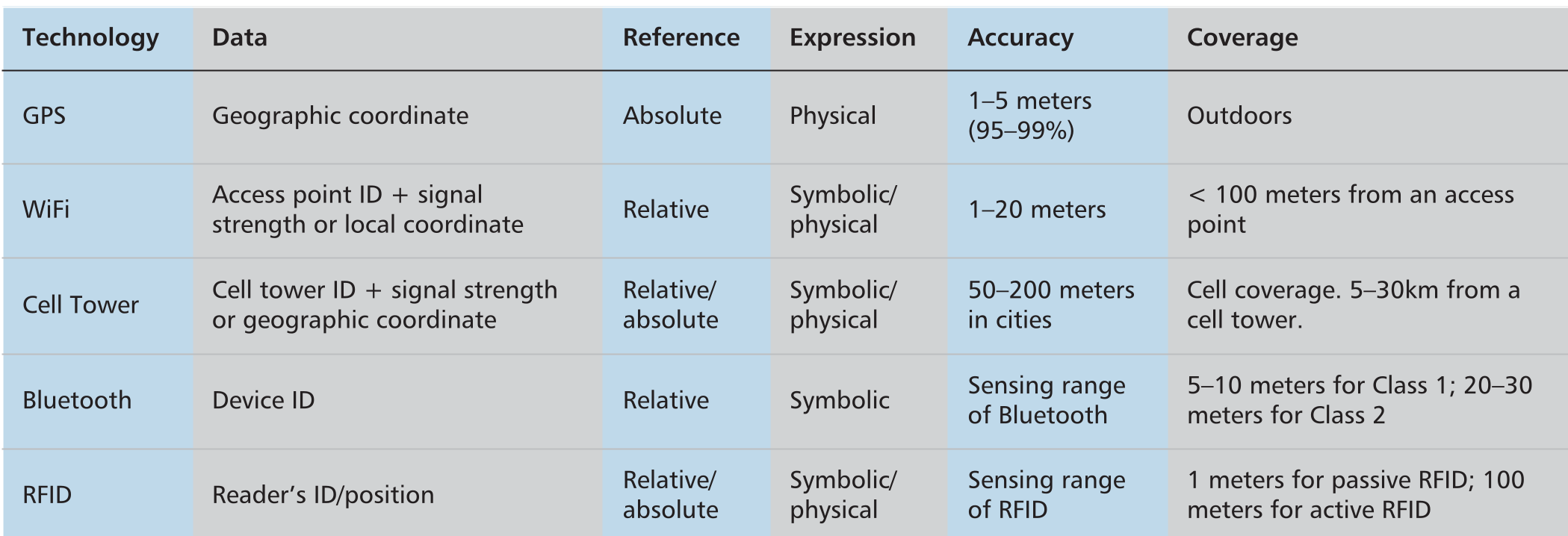
| Technology | Data Type | Accuracy | Coverage |
|---|---|---|---|
| GPS | Geographic Coordinate | 1-5 meters | Outdoors |
| WiFi | AP ID + Signal Strength | 1-20 meters | < 100 meters |
| Cell Tower | Tower ID | 50-200 meters | 5-30 km |
- Clustering: Used for discovering "Hotspots" or similar trajectories.
- Classification: Essential for "Activity Recognition" (e.g., distinguishing between walking, driving, or sitting).
- Physical Statistical Modeling: Applying concepts like Power Laws and Lévy Flights to explain the underlying "physics" of how humans move.
Domain Applications
The paper identifies five "Promising Application Domains" where trace mining creates tangible value:
- Smart Transportation: Real-time traffic monitoring and route recommendation.
- Smart Urban Planning: Evaluating land use by analyzing the "visiting frequency" of specific infrastructures.
- Smart Public Health: Monitoring the spread of epidemics via co-presence data.
- Smart Public Security: Detecting anomalous behavior (e.g., suspected criminal movement) or managing crowds in disasters.
- Smart Commerce: Location-based advertising (LBA) and personalized shopping services.
Deep Insight: The Privacy Paradox
One of the most profound insights provided is the Privacy-Utility Trade-off. While "Location Privacy" is critical to prevent unwanted surveillance, the "Fidelity of Data" is required for smart services to work. The authors suggest that while GPS is technically more "private" (as it doesn't necessarily require a central server to know the ID), the risk of Individuality Disclosure remains high because humans have unique, highly predictable movement signatures.
Critical Analysis & Conclusion
While this work provides an excellent structural foundation, it was written before the explosion of Deep Learning (DL). Modern readers should note:
- Pros: Excellent classification of sensors and research issues; strong bridge between Physical Modeling and Data Mining.
- Limitations: The paper relies heavily on "Feature Engineering" (extracting specific geometric curves or string features), whereas modern SOTA methods use Graph Neural Networks (GNNs) to automatically learn urban spatial relationships.
- Future Work: The challenge remains in Cross-Domain Inference—merging disparate datasets (e.g., combining Smart Card data with Air Quality sensors) to create a truly holistic view of the city.
Takeaway: Trace data is the lifeblood of the smart city, but the true intelligence lies not in the data itself, but in the sophisticated mining algorithms that extract human intention from spatial coordinates.