
Beyond Speed: Leveraging Environmental Constraints for Precise Transportation Inference
Transportation mode inference using environmental constraints
The paper introduces an Environmental Constraint-based Transportation Mode Inference (ECTMI) method to identify movement types (walking, bus, taxi, train) from GPS trajectories. By integrating geographic GIS data as constraints, the method achieves 90.8% recall across four modes, significantly outperforming velocity-only approaches.
TL;DR
Inferring whether a person is walking, riding a bus, or taking a train from simple GPS data is notoriously difficult—especially when vehicles stop. This paper proposes a method that uses Environmental Constraints (like known bus routes and train stations) to refine raw GPS data. The result? A jump from 80.4% to 90.8% recall and a massive reduction in "noisy" segment fragments.
The "Low Velocity" Trap
Most motion-sensing algorithms follow a simple logic: if you move fast, you're in a car; if you move slow, you're walking. However, urban reality is messier. Buses wait at stops; trains enter stations; taxis get stuck in traffic. In these moments, a velocity-only model sees a "slow-down" and incorrectly labels the segment as "Walking." This creates a fragmented trajectory that looks like a user jumping in and out of vehicles every few minutes.
The Proposed Solution: Context is King
The authors at Kyoto University argue that we shouldn't just look at how fast an object moves, but where it is moving. They define Environmental Constraints as the physical "guardrails" of movement:
- Points: Railway stations and bus stops (where speed naturally drops).
- Lines: Railway tracks and bus routes (where only specific modes are possible).
- Areas: Pedestrian spots or car parks.
The Workflow
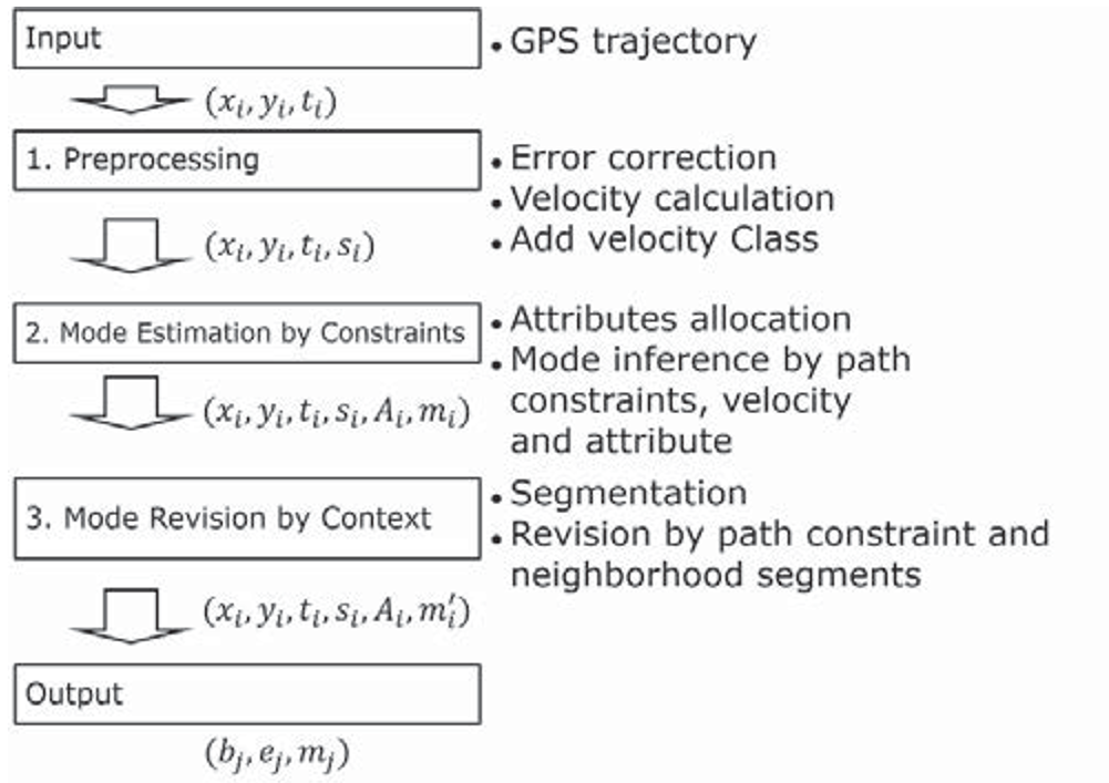
- Preprocessing: Using an Extended Kalman Filter (EKF) to smooth noisy GPS signals and remove outliers.
- Temporal Labeling: Assigning a probable mode to each point based on the intersection of velocity and GIS data (e.g., if velocity is high and the point is on a rail line, label it "Train").
- Contextual Revision: Merging consecutive points into "segments." If a small "slow" segment is sandwiched between two "Bus" segments and located near a bus stop, the system intelligently merges it back into the "Bus" category.
Experimental Validation
The study tracked 60 tourists in the Kinki area of Japan (Kyoto, Osaka, Nara). This is a challenging environment with high building density (causing GPS multi-path errors) and complex public transport networks.
Dramatic Improvement in Segment Accuracy
The true breakthrough wasn't just the recall percentage, but the coherence of the data.
- Velocity-only models predicted over 7,000 different trip segments (highly fragmented).
- The Proposed Method predicted 884 segments.
- Ground Truth was 515.
While still over-segmenting, the proposed method is an order of magnitude closer to reality, making the data actually useful for urban planners and tourism marketers.
Critical Insight: The "Taxi vs. Bus" Problem
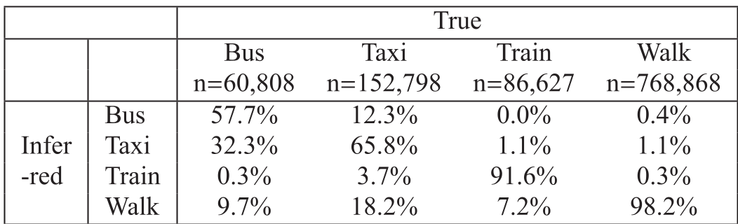
Even with environmental constraints, buses and taxis remain difficult to distinguish because they share the same roads. The authors addressed this by:
- Grouping them as "Car Mode."
- Using Bus Stop proximity as a secondary filter: if a vehicle consistently slows down exactly where bus stops are located, it's likely a bus; otherwise, it's a taxi.
Conclusion and Future Directions
This research proves that static GIS data can compensate for the limitations of simple GPS hardware. For industry applications—such as automatic "carbon footprint" trackers or smart city traffic management—integrating these environmental "guardrails" is essential.
The next frontier? Online Inference. Current models need the "entire trip" to be finished before they can revise labels. Moving this to a real-time, streaming architecture would allow for live evacuation support and instant tourist recommendations.
References:
- Kasahara, H., et al. (2017). Transportation mode inference using environmental constraints. IMCOM '17.