
mPASS: Engineering Trust in Smart City Sensing for Urban Accessibility
On the Need of Trustworthy Sensing and Crowdsourcing for Urban Accessibility in Smart City
The paper introduces mPASS (mobile Pervasive Accessibility Social Sensing), a system designed to map urban accessibility for people with disabilities. It leverages a hybrid data collection model combining crowdsourcing, crowdsensing, and authoritative datasets to provide personalized, barrier-aware navigation with a trustworthy data validation mechanism.
TL;DR
Navigating a city is a vastly different experience for a wheelchair user or a person with visual impairments compared to an average pedestrian. mPASS is a system that maps architectural barriers by fusing "crowd" reports with mobile sensor data. Its core innovation is a mathematical framework to quantify trustworthiness, ensuring that the navigation paths suggested are not just efficient, but physically accessible.
The "Curb Cut" Problem and Data Scarcity
In urban planning, the curb cut effect suggests that accessibility features benefit everyone—think of parents with strollers or travelers with luggage. However, digital maps rarely include these details. Prior efforts to crowd-source this data often failed because:
- Spam/Malice: Users might submit wrong data.
- Sensor Noise: Accelerometers in pockets often produce false positives for "stairs."
- Staleness: Urban environments change (e.g., road construction).
The authors argue that for a system to be usable by people with disabilities, it must provide a reliability guarantee.
Methodology: The Architecture of Trust
The mPASS system utilizes a three-component backend to maintain a "living" map of the city.
1. The Trustworthiness Formula
The system treats the presence of an Accessibility Point of Interest (aPOI) as a value between -1 (absent) and 1 (present). It balances positive and negative reports weighted by the source's credibility and sensor accuracy .
2. The Verification Loop
When the system detects a conflict (e.g., one person says there is a ramp, another says there is a step), the Notification Module takes action. It identifies "Expert" users (those with historical credibility > 0.7) currently in the vicinity and asks them for a live verification.
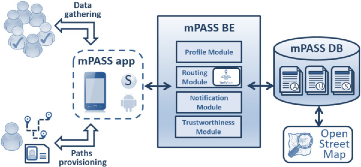 Fig 1: The mPASS architecture showing the flow from sensing to the Trustworthiness Module.
Simulation: Can the Crowd Outrun the Liars?
Using the GeoMason simulator, the researchers modeled thousands of agents in the streets of Bologna, Italy. They introduced "malicious" agents to test the system's resilience.
Key Findings:
- Majority Voting vs. Sensors: In scenarios with 50% malicious users, crowdsourcing alone failed. However, when crowdsensing (automatic sensor detection) was enabled, the physical evidence from sensors corrected the human misinformation (See Fig 10).
- Temporal Weighting: The system uses a logarithmic decay to prioritize recent reports, allowing the map to update as construction projects begin or end.
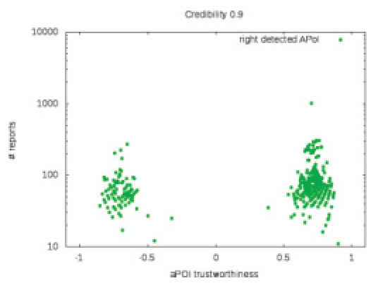 Fig 2: Trustworthiness of aPOIs. As the number of reports increases, the system's confidence (green circles) clearly separates true positives from negatives.
Critical Insight: Beyond "One Size Fits All"
mPASS doesn't just provide a "short" path. It categorizes user preferences into LIKE, DISLIKE, AVOID, and NEUTRAL.
- A wheelchair user will AVOID stairs.
- An elderly person might LIKE stairs for exercise but AVOID steep ramps.
- A blind user LIKES audible traffic signals.
This granular profiling transforms the routing engine from a simple Dijkstra implementation into a personalized accessibility assistant.
Conclusion & Future Outlook
The mPASS project demonstrates that Veracity is the most important "V" of Big Data in the context of human safety. While the system shows high accuracy in simulations, the real-world challenge remains the Incentive Gap—getting enough users to keep the app running. Future research into "Pervasive Games" (gamifying the reporting of barriers) might be the key to reaching that elusive critical mass.
Limitations
- Battery Drain: Constant GPS and accelerometer sensing can significantly impact mobile battery life.
- Demographic Bias: The "Expert" users are often those most tech-savvy, potentially neglecting areas used by less connected populations.