
Sextant: Turning Store Logos into Universal Navigational Anchors
Towards ubiquitous indoor localization service leveraging environmental physical features
The paper introduces Sextant, a ubiquitous indoor localization system that leverages static environmental physical features (e.g., store logos) as reference points. By measuring relative angles via a smartphone's gyroscope and matching images with a backend server, it achieves 4-5m accuracy at 80-percentile without relying on volatile RF signatures.
TL;DR
Researchers from Peking University have developed Sextant, an indoor localization system that ditches the headache of WiFi fingerprinting. Instead of scanning for invisible signals, it uses your smartphone to "point and shoot" at physical features like store logos or posters. It achieves 4-5m accuracy in massive malls and train stations with a fraction of the setup time required by traditional methods.
The Problem: The High Cost of "Invisible" Maps
Current indoor navigation (like Google Indoor Maps) mostly relies on RF Signatures (WiFi and Cellular). While functional, these maps are a nightmare to maintain:
- Calibration Fatigue: RSSI (signal strength) fluctuates constantly; maps need frequent re-scanning.
- Density Limits: If there aren't enough WiFi APs or cell towers, localization fails.
- Incentive Gap: Crowdsourcing maps is slow because users have little reason to contribute raw data.
Methodology: The "Sextant" Physics
The core insight is simple: physical environmental features (logos, paintings, signs) are static, abundant, and impervious to RF interference.
1. Relative Angles vs. Digital Compass
The authors found that the smartphone's digital compass is highly susceptible to electromagnetic "noise" (drifting up to 40°). However, the gyroscope is incredibly stable. Sextant uses Relative Angle-based Triangulation: the user stands still, rotates, and identifies three reference points. The internal gyroscope measures the angles between them ( and ), and the system intersects two circles to find the user.
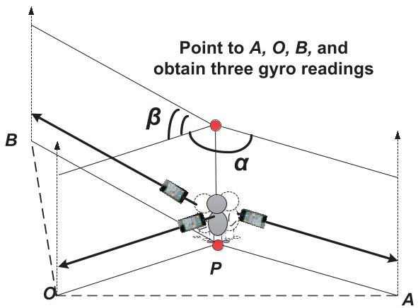 Figure: The user points the phone at three reference objects; the gyroscope tracks the rotation angles to triangulate the location.
2. Solving the "Survey" Bottleneck
To avoid professional surveying, the team created a hop-by-hop lightweight survey. By measuring just one "starting pair" distance, two workers can calculate the coordinates of all other visible points using simple geometry, resetting errors every few hops. This cut setup time for a 60,000m² train station down to just 2.6 man-hours.
Experiments and Results
Testing was conducted in two massive real-world environments: a shopping mall and a busy train station.
Performance vs. Industry Standards
- Mall: 80-percentile error of ~2m.
- Train Station: 80-percentile error of ~4.5m. This level of accuracy is on par with the industry gold standard (Google Indoor Maps) but without the need for periodic re-calibration.
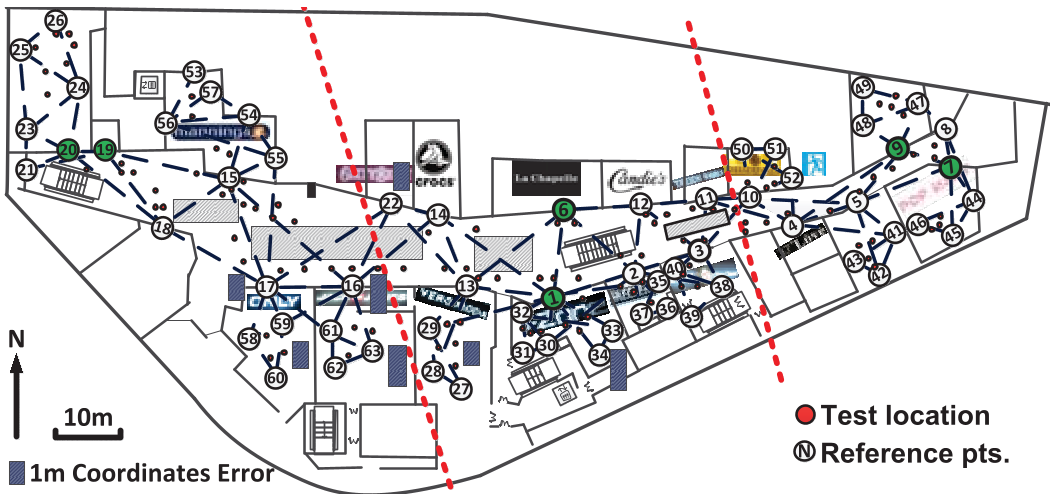 Figure: The mall floor map showing 63 reference points and the localization test results.
Correcting Human Error
The system identifies reference points using SURF (Speeded Up Robust Features) image matching. When the computer makes a mistake (due to extreme angles or similar-looking storefronts), a Closeness Heuristic kicks in. It assumes that the three points you picked are likely near each other and not blocked by walls, correcting "impossible" matches automatically.
Critical Analysis & Takeaways
Sextant proves that we don't need complex IT infrastructure to navigate indoors. Its greatest strengths are persistence (the map doesn't expire) and cost-efficiency.
Limitations:
- It is not yet "continuous" (you have to stop and point).
- It requires clear line-of-sight; a crowded mall with walking people can obstruct the "anchors."
Future Outlook: The next step for this technology is integrating it with Visual SLAM or Dead-Reckoning, allowing the phone to track you as you walk between these visual anchors. As AR glasses become more common, this "point-to-locate" logic will likely become the backbone of invisible indoor navigation.
Conclusion
Sextant shifts the localization paradigm from "listening to signals" to "seeing features." By leveraging the physical world's stability, it offers a path toward truly ubiquitous indoor localization that is easy to deploy and even easier to maintain.