
Urban Observation 2.0: Fusing the Satellite Perspective with the Human Footprint
Urban Observation: Integration of Remote Sensing and Social Media Data
This paper provides a comprehensive survey on the integration of Remote Sensing (RS) and Social Media Data (SMD) for urban observation. It categorizes the fusion of these heterogeneous "Big Data" sources into four primary domains: social-environmental relationships, urban planning, disaster management, and environmental monitoring, highlighting how SMD provides the "human-centric" context often missing from satellite imagery.
TL;DR
This survey explores the powerful convergence of Remote Sensing (RS) and Social Media Data (SMD). By treating individuals as "social sensors," researchers are overcoming the inherent limitations of satellite revisit times and spectral constraints. The paper outlines a transition from static physical monitoring to dynamic, human-centric urban observation, achieving significant gains in land-use classification and real-time disaster response.
Background: Why Satellites Are Not Enough
For decades, urban observation was a top-down affair. If you wanted to map a city's growth or a flood's extent, you looked at satellite pixels. However, pixels don't talk. They can show you a building's shape, but not its function; they can show water, but not the human impact or the "on-the-ground" severity. Traditional RS faces the "Resolution/Latency Trade-off": high-resolution data is often expensive and infrequent.
SMD (tweets, check-ins, geotagged photos) offers a solution: high-frequency, "zero-cost" human data. The challenge? SMD is unstructured, biased, and spatially irregular.
The Synergy Taxonomy
The paper categorizes the integration of these data sources into a clear hierarchy of urban needs:
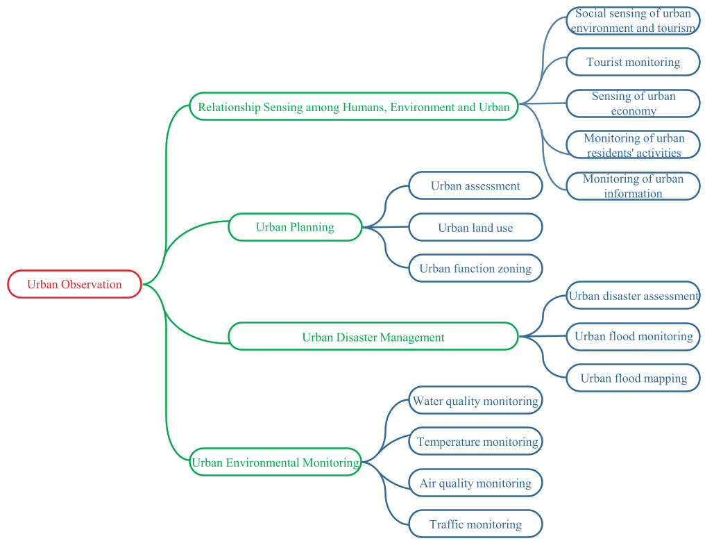
- Relationship Sensing: Understanding how humans interact with the built environment (e.g., tourism flows, economic divides).
- Urban Planning: Delineating functional zones (where people work vs. live) by combining building density (RS) with check-in volume (SMD).
- Disaster Management: Leveraging "vocal" survivors on social media to task satellites or refine flood maps in near real-time.
- Environmental Monitoring: Using "heat-tweets" and air pollution complaints to densify sparse physical sensor networks.
Methodology: Bridging Pixels and Text
The core innovation in the cited works lies in Multimodal Fusion. The technical pipeline typically involves:
- Feature Extraction: CNNs extract spatial features from VHR (Very High Resolution) imagery, while NLP (Natural Language Processing) and Topic Modeling (like LDA) extract semantic themes from SMD.
- Decision Fusion: Using Support Vector Machines (SVM) or Random Forests to weight the influence of physical vs. social indicators.
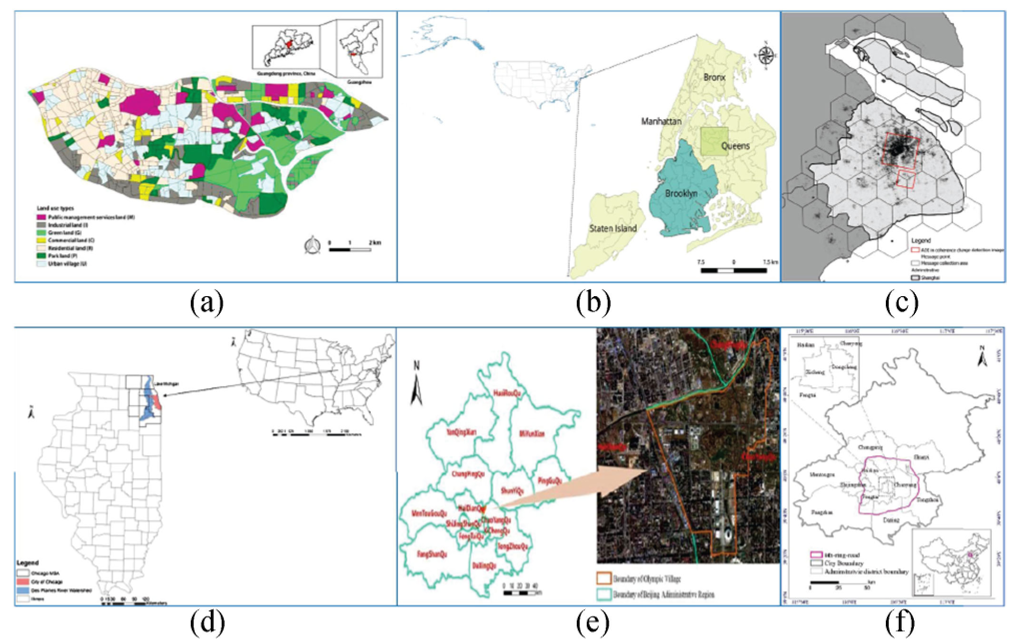 Figure: Various case studies (New York, Shanghai, Chicago) demonstrating how check-in data (colored dots) aligns with the physical urban fabric.
Critical Results: Better Together
The evidence for fusion is quantitative. In urban land-use tasks, single-source RS often struggles to distinguish between "Residential" and "Commercial" zones that look identical from above. By adding SMD, studies reported accuracy boosts of up to 10-15%.
In disaster management, the 2015 South Carolina flood study (Fig 3 in the paper) showed that Twitter data could predict inundation probability in the gaps between satellite passes, providing emergency responders with a "living map."
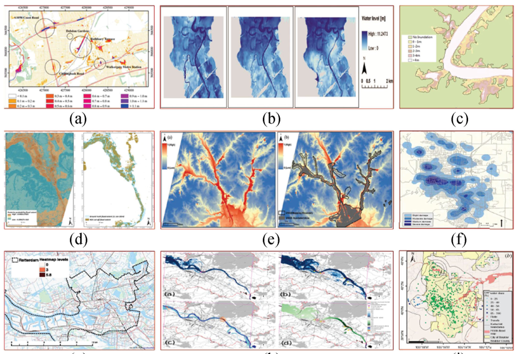 Figure: Real-time flood probability mapping using fused Twitter streams and post-event imagery.
Critical Insight & Future Outlook
While the survey is comprehensive, it points to a "trust gap." SMD is notorious for noise, bots, and demographic bias (the "digital divide"). The next frontier in this field isn't just more data, but Knowledge Retrieval:
- HPC & Cloud: The sheer volume of high-res imagery + global social streams requires High-Performance Computing.
- Privacy vs. Utility: As we "observe" cities more closely, protecting individual privacy while extracting urban insights remains a delicate balance.
Conclusion: Urban observation is moving away from being a "hardware-only" discipline. The integration of social media transforms the city into a living organism where every resident is a potential data point, and every satellite is a global auditor.